
Search Data.gov
Found 299 dataset(s) matching "3D mapping".
-
The objective of this shape retrieval contest is to retrieve 3D models those are relevant to a query range scan. This task corresponds to a real life scenario where the query is a 3D range scan of...
-
The objectives of this shape retrieval contest are to evaluate the performance of 3D shape retrieval approaches on a new generic 3D shape benchmark. Task description: In response to a given set...
-
The objective of this shape retrieval contest is to retrieve 3D models those are relevant to a query range scan. This task corresponds to a real life scenario where the query is a 3D range scan of...
-
Corescan© Hyperspectral Core Imager Mark III (HCI-III) system data were acquired for hand samples, and subsequent billets made from the hand samples, collected during the U.S. Geological Survey...
-
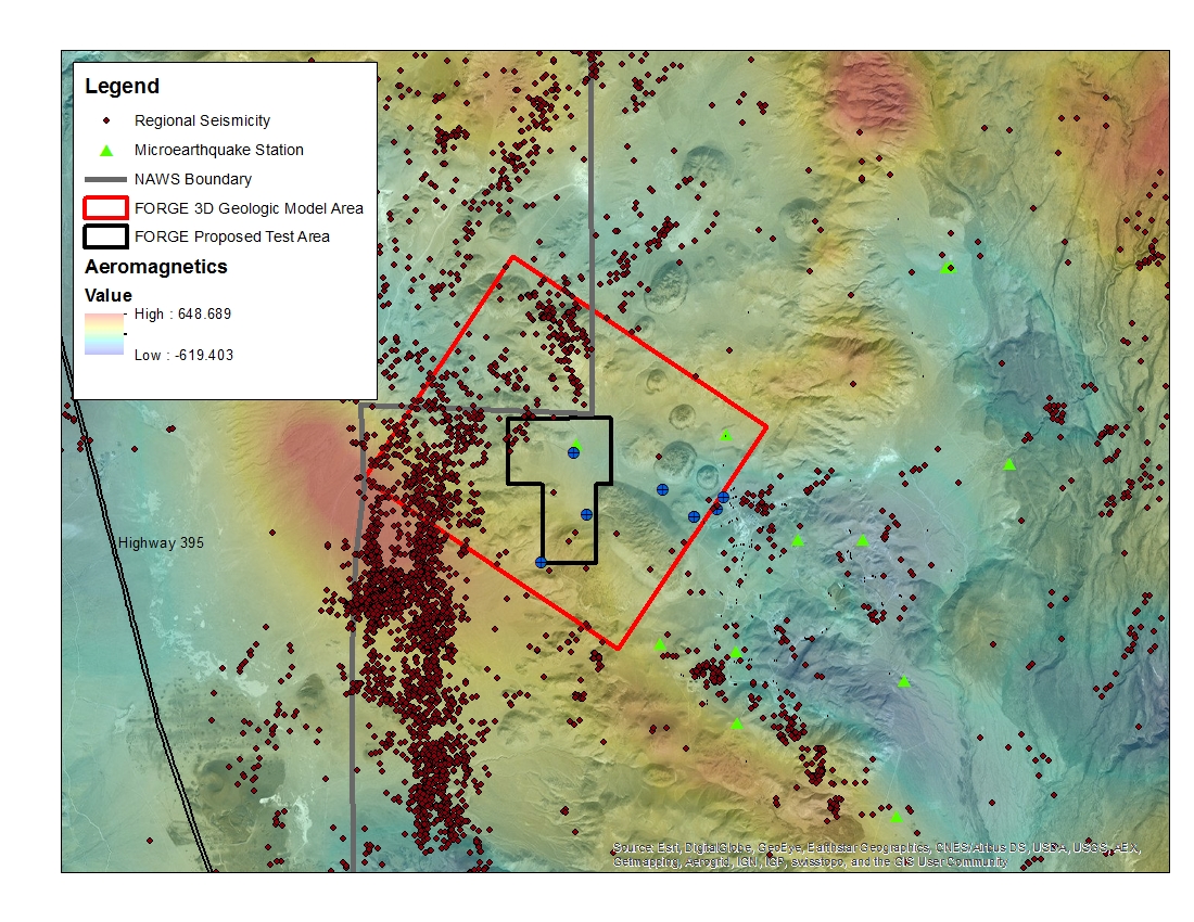
A map with the Coso West Flank FORGE test area outlined, along with regional seismicity, the aeromagnetic data set and the area currently being utilized for the creation of the 3D model.
-
World Wind is a collection of components that interactively display 3D geographic information within Java applications or applets.
-
This data submission contains GIS raster datasets mapping the visual impacts of the land-based wind turbine fleet in the Contiguous United States (CONUS). Two datasets are included, each...
-
The High Resolution National Hydrography Dataset Plus (NHDPlus HR) is an integrated datset of geospatial data layers, including the most current National Hydrography Dataset (NHD),...
-
This dataset consists of Structure-from-Motion derived point clouds and detailed orthomosaic images of two exposures covering the upper part of the Lockhaven Formation near Tioga, Pennsylvania....
-
This dataset consists of Structure-from-Motion derived point clouds and detailed orthomosaic images of four exposures covering the Williamsport Sandstone and the Bloomsburg Formation in eastern...
-
This dataset consists of Structure-from-Motion (SfM) - derived point clouds and detailed orthomosaic images of three exposures covering the Irish Valley Member of the Catskill Formation, near...
-
This package contains data and metadata for the 3d thermal model, well lithology logs, gravity grids and depth to basement inversions, play fairway modelling, and ArcGIS geodatabase...
-
<div style='box-sizing:border-box; color:rgb(0, 0, 0); font-family:"Source Sans Pro", Helvetica, Arial, sans-serif; font-size:16px;'><div style='box-sizing:border-box;...
-
This data release includes the input topographic data sets, model parameters, and validation field measurements of flow velocity used to develop and test multidimensional hydraulic models for a...
-
Rapid population growth and declining annual recharge to aquifers in the upper Santa Cruz basin area of southern Arizona, has increased the demand for additional groundwater resources. This...
-
This dataset contains a map, showing the Utah FORGE seismic stations, and seismic velocity model data. There are 61 1-D velocity models which are in a compressed TAR file. A paper is referenced at...
