
Search Data.gov
Found 433 dataset(s) matching "cross flow".
-
Workbooks showing Annualized Energy Production, Cost Breakdown Structure, Levelized Cost of Electricity for DOE Reference Tidal Project 1) Baseline TidGen Power System 2) TidGen Power System with...
-
Simulink model for a New Energy 5kW hydropower turbine. ADCP data ("ds_streamwise_7_13.nc") and DC voltage, DC current, and rotor rotation observed from the New Energy EVG-005 Current Energy...
-
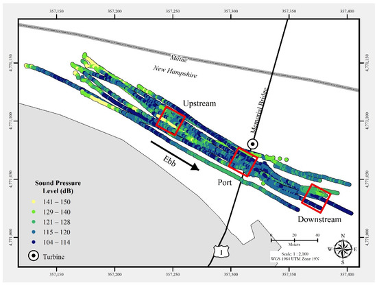
In July 2021, a commercial-off-the-shelf hydrophone was deployed in a free-drifting configuration to measure underwater acoustic emissions and characterize a 25 kW-rated tidal turbine at the...
-
A procedure was described for performing a fatigue analysis of composite foils for an MHK generator. The steps included generating load data, S-N (Stress versus Number of cycles to failure)...
-
The purpose of the Open Water Deployment Report is to provide an overview of the installation of the Ocean Renewable Power Company (ORPC) RivGen 2.0 Power System in Igiugig, AK, in 2019 beginning...
-
Seawater aging response was investigated in marine-grade glass/epoxy, glass/vinyl ester, carbon/epoxy and carbon/vinyl ester composites with respect to water uptake, interlaminar shear strength,...
-
Risk Register for the RivGen power system, optimized for performance, durability and survivability, in Microsoft Excel format.
-
This document contains a feasibility assessment for salmon smolt characterization and analysis based on existing hydroacoustics data and probability of encounter model.
-
Base data and documentation of LCOE calculations for ORPC's RivGen 1.F Power System, demonstrated in the Kvichak River at Igiugig, Alaska in 2015.
-
<div style="text-align:Left;"><div><div><p><span>Location and attributes for cross section lines in the area covered by the FIRM. This layer must contain all cross sections in a model, not just...
-
Field Data: The first ADCP data collection effort for this project was done on July 30th, 2015 represented with these bathymetric point locations on the Green River near Tukwilla, WA. Stream...
-
The dataset contains GPS survey data from two surveys conducted after a flow event on September 19, 2018, at the USGS streamgage 09487000 - Brawley Wash near Three Points, AZ. The first survey, on...
-
The dataset contains data from a GPS survey conducted after a flow event on November 29, 2019, at the USGS streamgage 09471580 - San Pedro River at St David, AZ. The survey, conducted on December...
-
The dataset contains GPS survey data from two surveys conducted after a flow event on February 15, 2019, at the USGS continuous slope-area (CSA) gage 09484201 - Bear Creek above Bear Canyon Road,...
-
The U.S. Geological Survey and the University of Massachusetts at Amherst (UMass Amherst), in cooperation with the Massachusetts Department of Environmental Protection (MassDEP), began a series of...
-
The U.S. Geological Survey (USGS) created geospatial datasets of potential culvert locations along with flowlines connected to southwestern Lake Erie as part of the Western Lake Erie Restoration...
-
The U.S. Geological Survey (USGS) created the Degree Flowlines and Culverts geospatial datasets representing potential culvert locations along with flowlines within the Connecting River Systems...
-
Geomorphology monitoring sites at 15 locations along the Roanoke River in Salem and Roanoke, Virginia, represented riffle or pool habitats and were designed to facilitate repeated measuring at the...
-
The U.S. Geological Survey (USGS) created geospatial datasets of potential culvert locations along with flowlines connected toLake Huron as part of the Saginaw Bay Restoration Assessment (SBRA)....
