
Search Data.gov
Found 23 dataset(s) matching "tularosa".
-
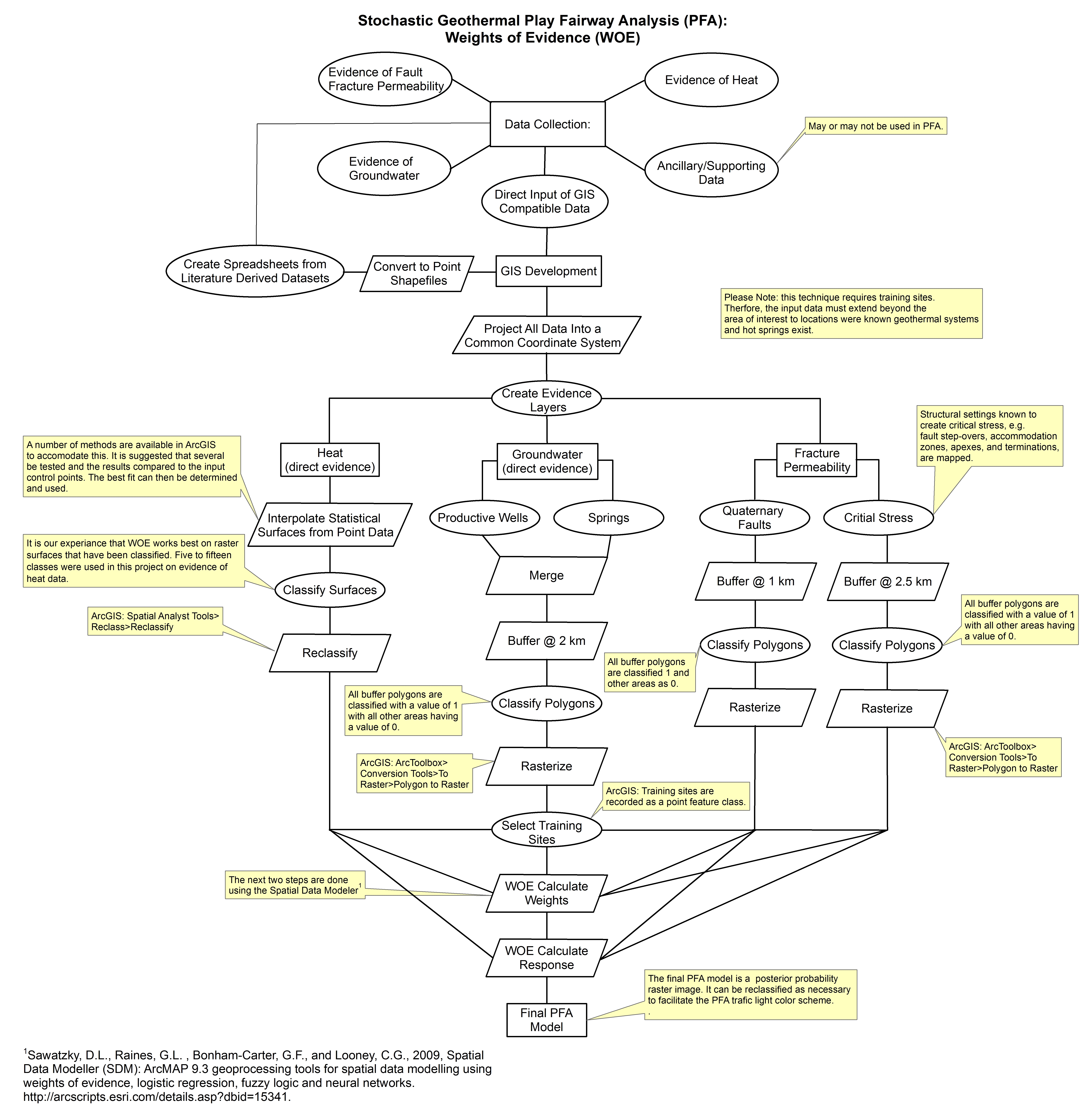
These models are related to weights of evidence play fairway anlaysis of the Tularosa Basin, New Mexico and Texas. They were created through Spatial Data Modeler: ArcMAP 9.3 geoprocessing tools...
-
This is a hydrothermal alteration map of the Tularosa Basin area, New Mexico and Texas that was created using Advanced Spaceborne Thermal Emission and Reflection Radiometer (ASTER) multispectral...
-
Tularosa Basin Play Fairway Analysis: Partial Basin and Range Heat and Zones of Critical Stress Maps
Interpolated maps of heat flow, temperature gradient, and quartz geothermometers are included as TIF files. Zones of critical stress map is also included as a TIF file. The zones are given a 5km...
-
This submission includes a geotiff of the geographic extent of Pleistocene Lake Otero; which was used as apart of the groundwater composite risk segment in a Tularosa Basin Play Fairway Analysis.
-
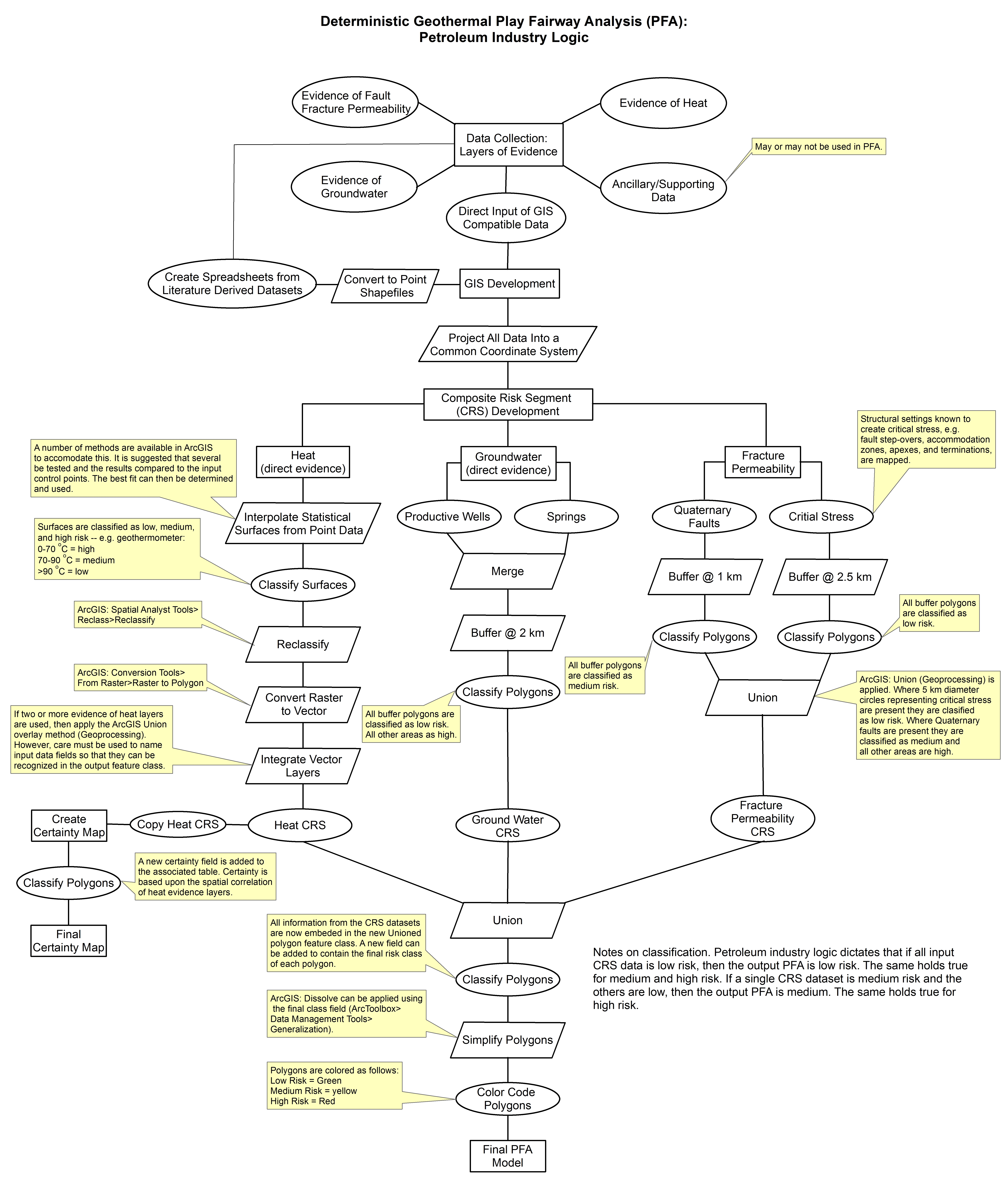
These images show the comprehensive methodology used for creation of a Play Fairway Analysis to explore the geothermal resource potential of the Tularosa Basin, New Mexico. The deterministic...
-
This report describes all of the work done in Phase I of a geothermal exploration project in the Tularosa Basin, as well as an outline for Phase II work, and more.
-
Tularosa Basin Play Fairway Analysis: Modeled MT Resistivity Data for the McGregor Range, New Mexico
This is the inversion resistivity data from a magnetotelluric survey done as part of Phase 2 Tularosa Basin, New Mexico, geothermal play fairway analysis. The data covers part of McGregor Range,...
-
A DEM of the Tularosa Basin was divided into twelve zones, each of which a ZR ratio was calculated for. This submission has a TIFF image of the zoning designations, along with a table with...
-
This shapefile contains 409 well data points on Tularosa Basin Water Chemistry, each of which have a location (UTM), temperature, quartz and Potassium/Magnesium geothermometer; as well as...
-
This report details all of the work done in Phase 2 of a geothermal exploration project in Tularosa Basin, New Mexico. Data acquired as part of Phase 2 includes field geology (geological...
-
This submission contains multiple excel spreadsheets and associated written reports. The datasets area are representative of shallow temperature, geochemistry, and other well logging observations...
-
This is a zipped file containing raw magnetotelluric (MT) data collected as part of the Phase 2 Tularosa Basin geothermal play fairway analysis project in New Mexico. The data for each MT station...
-
This is a zipped ArcGIS shapefile containing faults mapped for the Tularosa Basin geothermal play fairway analysis project. The faults were interpolated from gravity and seismic (NASA area) data,...
-
This submission has two shapefiles and a tiff image. The weights of evidence analysis was applied to data representing heat of the earth and fracture permeability using training sites around the...
-
This is a digitized geologic map, in shapefile format, including rock unit lithological descriptions, faults, and dikes.
-
This dataset contains a variety of data about the Fort Bliss geothermal area, part of the southern portion of the Tularosa Basin, New Mexico. The dataset contains schematic models for the...
-
A complete set of alluvial basin boundaries in the upper Rio Grande Basin were compiled in a digital format for the groundwater component of a Focus Area Study (FAS). A literature and data search...
