
Search Data.gov
Found 16 dataset(s) matching "steam flow".
-
Distributor for two-phase mixtures, including a distributor drum, a feed tube leading into the distributor drum in a given direction, a plurality of outlet tubes leading from the distributor drum...
-
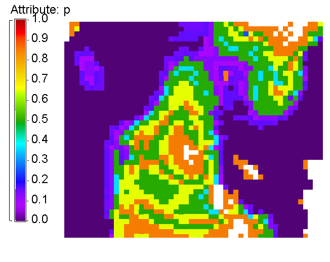
These histograms represent our calibration of conductance of a volcanic geothermal field (with a clay cap) and the observed steam flow rates. Darajat is a vapor geothermal field located in West...
-
A self-venting cover for a heatable food package comprises a sheet of film having a slit formed therein to permit the passage of steam therethrough. A label is secured to the film for controlling...
-
This data release provides semiquantitative mineralogy results from X-ray diffraction (XRD) analyses of mineral scales from The Geysers vapor-dominated geothermal field in California. The mineral...
-
The turbine set (1) has the gap between the turbine blades widened or narrowed in dependence on the supplied gas or steam quantity and/or the inclination and/or length of the turbine blades...
-
The spreadsheets associated with this metadata file represent: (Tab 1) Streamflow and drainage basin characteristics of selected gaged steams in Hawaii used to develop statistical models to...
-
The spreadsheets associated with this metadata file represent: (Tab 1) Streamflow and drainage basin characteristics of selected gaged steams in Hawaii used to develop statistical models to...
-
This dataset contain records factors for emissions and releases of chemicals to air, water and ground, waste generation, from electricity generation, All values are per megawatt-hour (MWh) of...
-
Alamagan Volcano is a Quaternary stratovolcano along the Mariana Arc, an active subduction zone in the western Pacific Ocean. Although primarily submerged, its peak reaches above sea level, with...
-
Caldwell Ranch Exploration and Confirmation Project, Northwest Geysers, CA: 2011 Geothermal Technologies Peer Review Project Summary The Caldwell Ranch Exploration and Confirmation Project was to...
-
Geothermics is the study of heat generated in Earth's interior and its manifestation at the surface. The NOAA National Centers for Environmental Information has a variety of publications and data...
-
The Yellowstone Volcano Observatory (YVO) was established as a collaboration between the U.S. Geological Survey and Yellowstone National Park "To strengthen the long-term monitoring of volcanic...
-
This 1:50,000-scale geologic map represents a compilation of the most recent geologic studies of the upper Arkansas River valley, between Leadville and Salida, Colorado. The valley is structurally...
-
This USGS data release contains 2013 streamflow, baseflow, and precipitation data from three hydrologically-diverse streams in the United States used to develop a conceptual framework for...
-
This shapefile contains location and attribute data for a shallow (2 meter) temperature survey conducted by Geothermal Technical Partners, Inc. during late 2008 and early 2009. Temperatures at 2m...
-
A database of geologic map of Lassen Peak, Chaos Crags, and Upper Hat Creek volcanic area as described in the original abstract: The Lassen Peak, Chaos Crags, and Upper Hat Creek map area lies...
