
Search Data.gov
Found 3747 dataset(s) matching "simulation data".
-
These are simulated data without any identifying information or informative birth-level covariates. We also standardize the pollution exposures on each week by subtracting off the median exposure...
-
This is a spatially-explicit state-and-transition simulation model (STSM) of sagebrush-steppe vegetation dynamics for greater sage-grouse (Centrocercus urophasianus) Priority Areas for...
-
<p>This study examined average annual changes in soil erosion from rainfall and wind forces, and trends in soil organic carbon (SOC). </p> <p>The diversity of geo-climatic land bases and potential...
-
This data release includes: (1) The data from simulations used to illustrate the behavior of inbreeding rate estimators. Estimating inbreeding rates is particularly difficult for natural...
-
Field measurements, daily meteorological inputs, and previously validated iSnobal simulations were used to run and inform the biogeochemical models Biome-BGC and Biome-BGC MuSo at three aspen...
-
Field measurements, daily meteorological inputs, and previously validated iSnobal simulations were used to run and inform the biogeochemical models Biome-BGC and Biome-BGC MuSo at three aspen...
-
**SPECIAL NOTE:** C-MAPSS and C-MAPSS40K ARE CURRENTLY UNAVAILABLE FOR DOWNLOAD. Glenn Research Center management is reviewing the availability requirements for these software packages. We...
-
The emission data which includes area and point sources, are directly from the 2016 CMAQ US CONUS domain (stored on atmos asm system, /asm/MOD3DATA/2016_12US1/emis/cb6r3_ae6_20190221). This...
-
ASIA-AQ_AircraftRemoteSensing_LaRC-G3_GCAS_Data is the Geostationary Coastal and Air Pollution Event (GEO-CAPE) Airborne Simulator Data (GCAS) data collected onboard the NASA LaRC G-III aircraft...
-
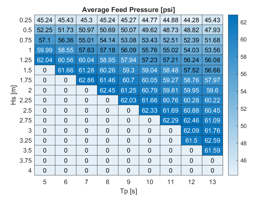
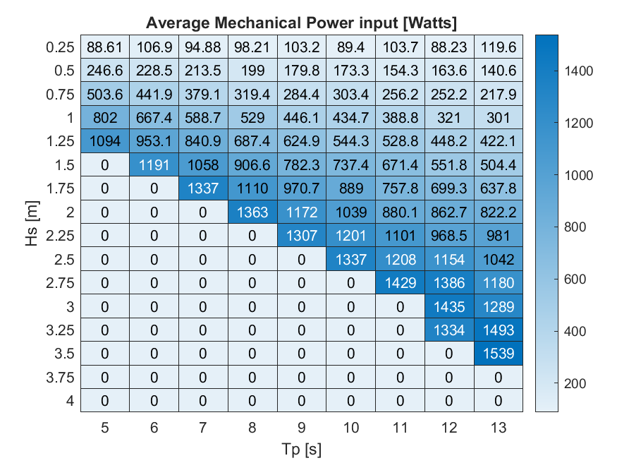
This dataset contains time-series simulation data generated by Pyro-E LLC using Simcenter STAR-CCM+ that characterizes the hydromechanical behavior of the Electrically Engaged unduLation (EEL)...
-
Data sets consists of multiple multivariate time series. Each data set is further divided into training and test subsets. Each time series is from a different engine i.e., the data can be...
-
SCAR_A_ER2_MAS data are Sulfates, Clouds and Radiation America (SCARA) NASA ER2 Moderate Resolution Imaging Spectrometer (MODIS) Airborne Simulator (MAS) Data in Hierarchical Data Format...
-
This data set consists of both measured and simulated optical intensities scattered off periodic line arrays, with simulations based upon an average geometric model for these lines. These data...
-
This data set consists of monthly long-term mean temperature data (degrees C) for the last glacial maximum (21 ka) downscaled to a 10-km grid of North America. The 10-km data were derived using...
-
The main dataset is a 232 MB file of trajectory data (I395-final.csv) that contains position, speed, and acceleration data for non-automated passenger cars, trucks, buses, and automated vehicles...
-
The main dataset is a 350 MB file of trajectory data (TGSIM-Foggy Bottom-Data.csv) that contains position, speed, and acceleration data for pedestrians, bicycles, scooters, non-automated passenger...
-
The main dataset is a 9 MB file of trajectory data (I294_L2_final.csv) that contains position, speed, and acceleration data for small and large automated (L2) and non-automated vehicles on a...
