
Search Data.gov
Found 319 dataset(s) matching "resource probability".
-
This data release presents an update to the Coastal Response Likelihood (CRL) model (Lentz and others 2015); a spatially explicit, probabilistic model that evaluates coastal response for the...
-
These data represent relative survival probability for greater sage-grouse during the late portion of the brood rearing season.
-
These data represent relative survival probability for greater sage-grouse during the early portion of the brood rearing season.
-
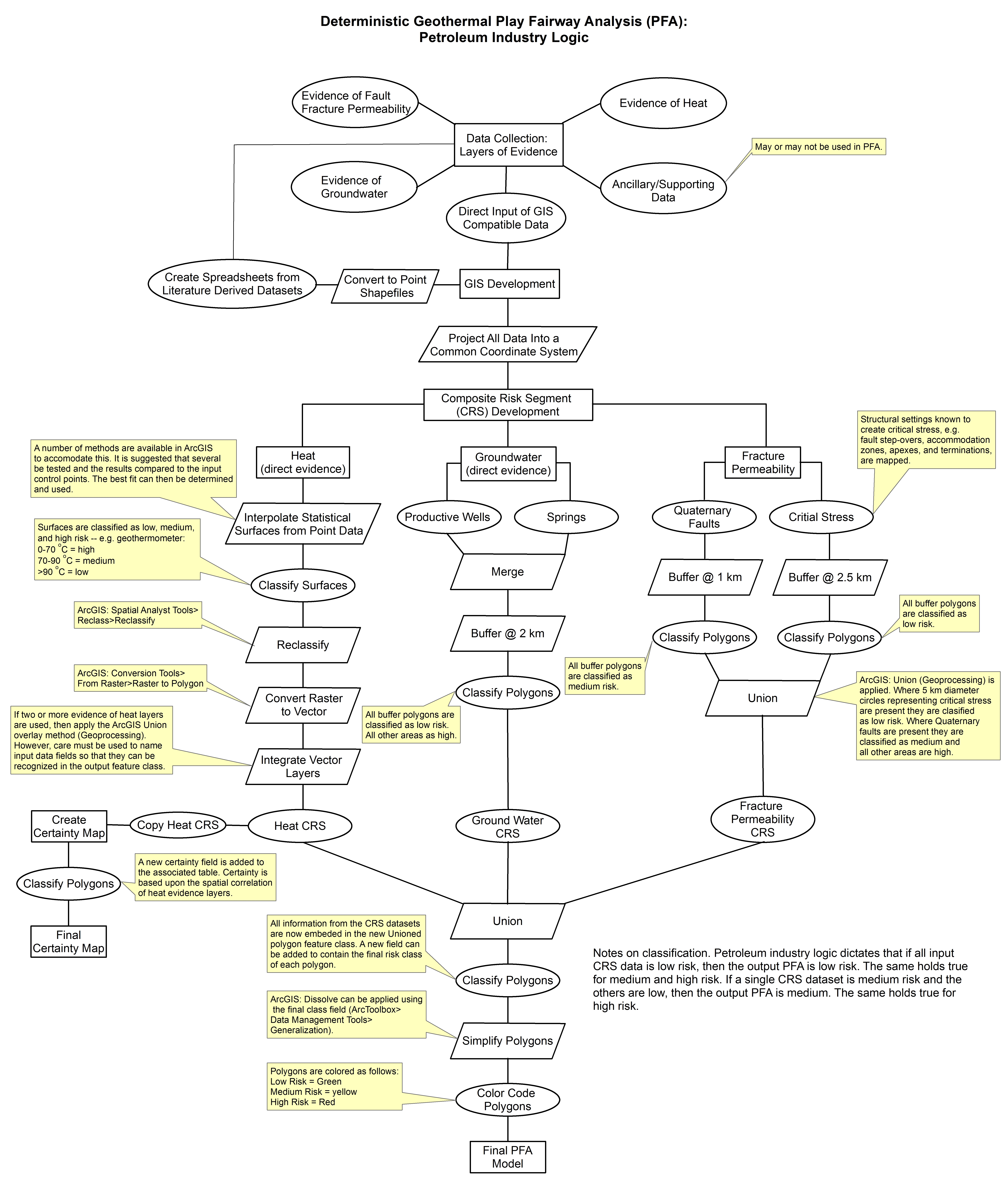
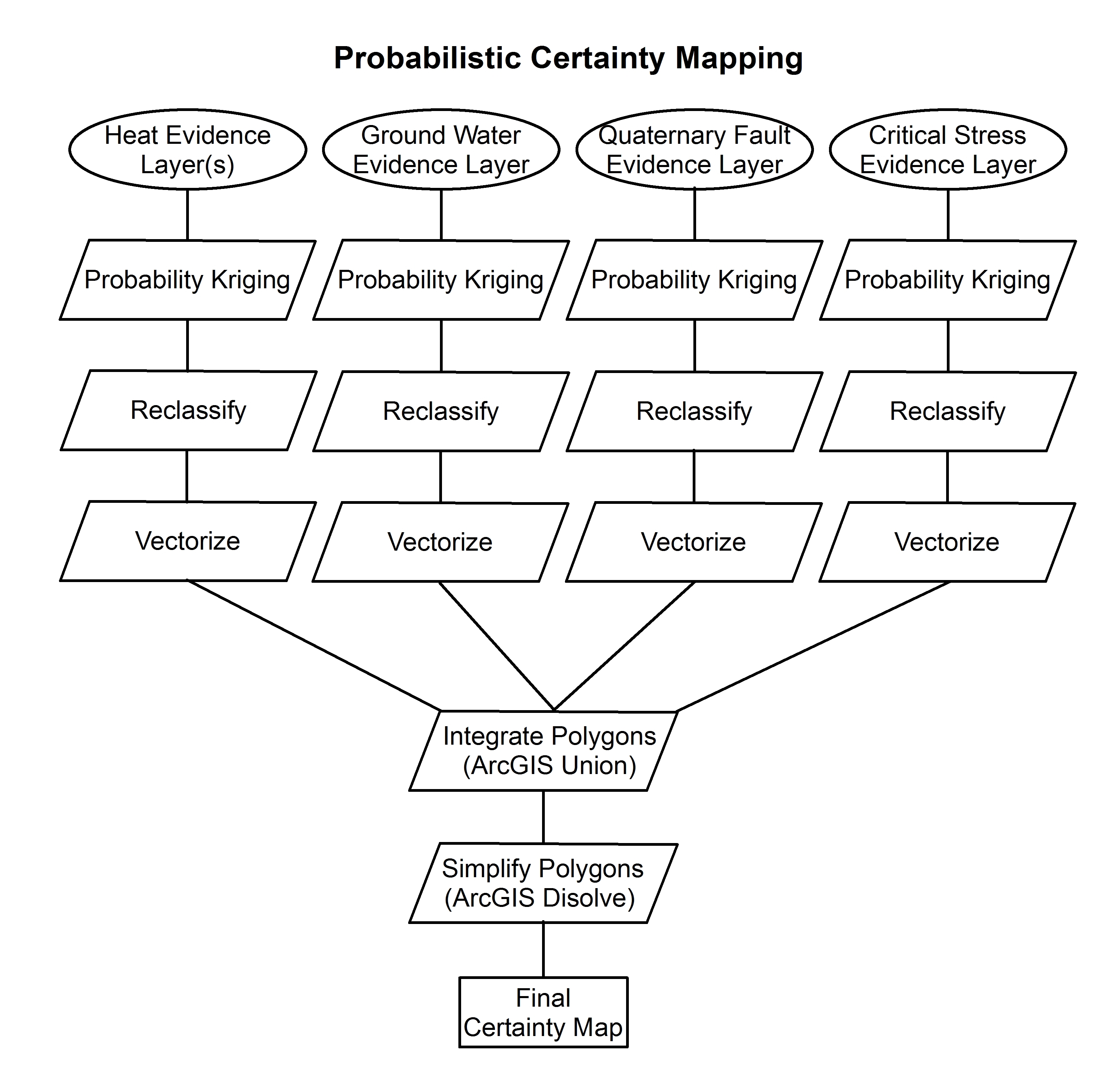
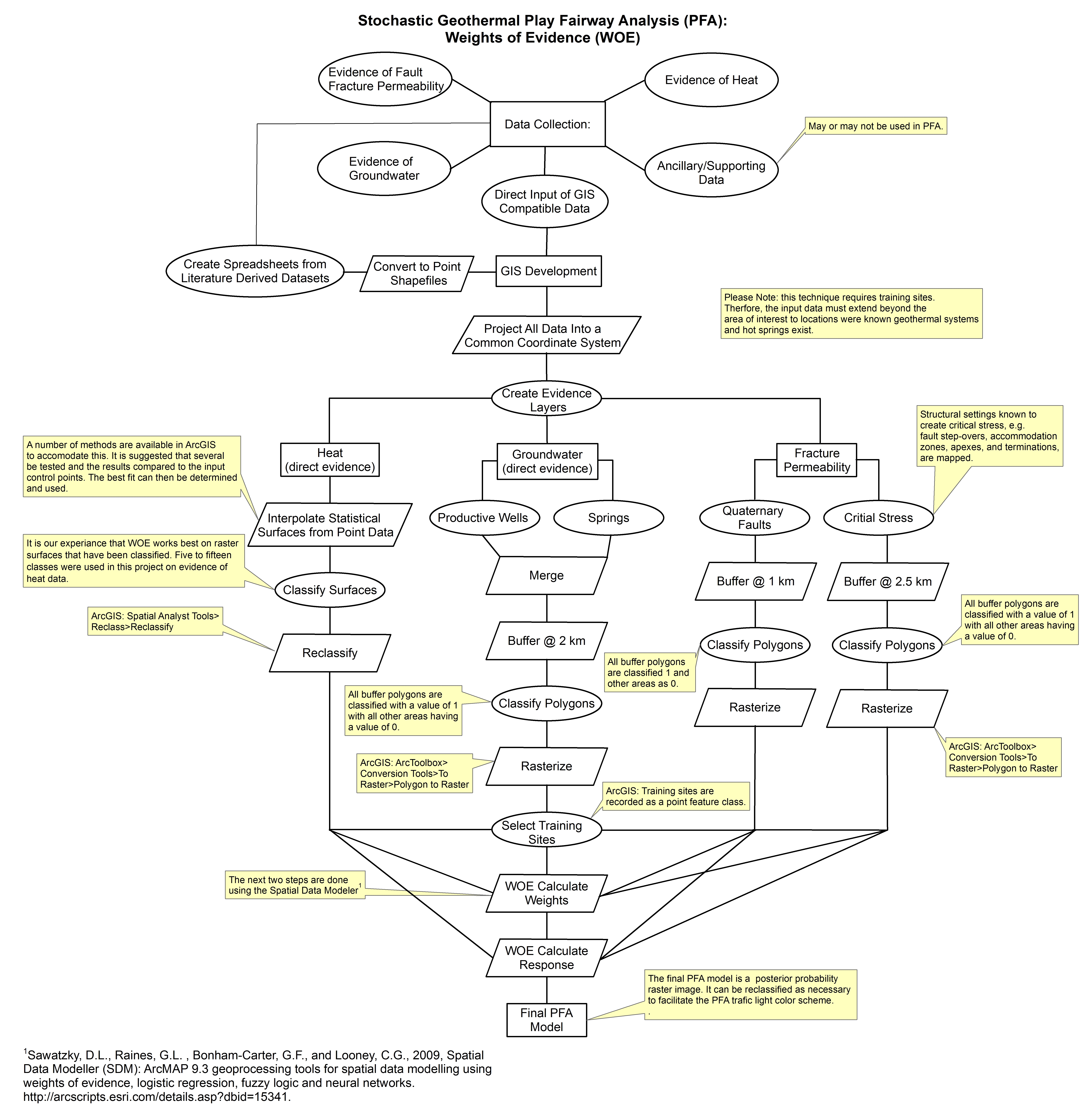
These images show the comprehensive methodology used for creation of a Play Fairway Analysis to explore the geothermal resource potential of the Tularosa Basin, New Mexico. The deterministic...
-
This dataset documents the results of large-scale surveillance efforts to assess coronavirus prevalence in North American bats. Wildlife monitoring is critical for establishing disease baselines...
-
This dataset is the 2023 version of wildfire hazard potential (WHP) for the United States. The files included in this data publication represent an update to any previous versions of WHP or...
-
This dataset is the 2023 version of wildfire hazard potential (WHP) for the United States. The files included in this data publication represent an update to any previous versions of WHP or...
-
These data represent relative survival probability for greater sage-grouse 50 days after hatching, approximately the end of the brood rearing life stage.
-
<DIV STYLE="text-align:Left;"><DIV><DIV><P><SPAN>Automated acoustic recorders were deployed at 331 sites across the Mojave Desert ecoregion and 263 sites across the Great Valley ecoregion between...
-
This dataset represents the results from conducted simulations to evaluate the performance of Device-to-Device (D2D) communications in LTE when the User Equipment (UEs) are operating in...
-
The U.S. Geological Survey has been forecasting sea-level rise impacts on the landscape to evaluate where coastal land will be available for future use. The purpose of this project is to develop a...
-
The U.S. Geological Survey has been forecasting sea-level rise impacts on the landscape to evaluate where coastal land will be available for future use. The purpose of this project is to develop a...
-
The U.S. Geological Survey has been forecasting sea-level rise impacts on the landscape to evaluate where coastal land will be available for future use. The purpose of this project is to develop a...
-
The U.S. Geological Survey has been forecasting sea-level rise impacts on the landscape to evaluate where coastal land will be available for future use. The purpose of this project is to develop a...
-
The U.S. Geological Survey has been forecasting sea-level rise impacts on the landscape to evaluate where coastal land will be available for future use. The purpose of this project is to develop a...
-
The T-3 (Fletcher's) Ice Island in the Arctic Ocean was the site of a scientific research station re-established by the Naval Arctic Research Laboratory starting in 1962. Starting in 1963, the...
-
The National Aeronautics and Space Administration (NASA) Aircraft Scanners data set contains digital imagery acquired from several multispectral scanners, including Daedalus thematic...
-
Landsat classification of surface water for multiple seasons to monitor inundation of playa wetlands
To improve understanding of the distribution of important, ephemeral wetland habitats across the Great Plains, we documented the occurrence and distribution of surface water in playa wetland...
-
This part of DS 781 presents data for the map showing the predicted distribution of tall sea pens in the Santa Barbara Channel, California, region. The raster data file is included in...
