
Search Data.gov
Found 1599 dataset(s) matching "Bridges".
-
<div style="text-align:Left;"><div><div><p><span>This file contains line data for pedestrian and rail bridges from AASHTO Bridge Management database.</span></p></div></div></div>
-
<div style="text-align:Left;"><div><div><p><span>This file contains line data for bridges from AASHTO Bridge Management database.</span></p></div></div></div>
-
The dataset contains incident response data from B&T’s seven bridges and two tunnels in New York City. Each record represents a monthly summary for a facility with the number of incidents...
-
This deprecated dataset provides data showing the number of vehicles (including cars, buses, trucks and motorcycles) that pass through each of the bridges and tunnels operated by the MTA each hour...
-
This deprecated dataset provides data showing the number of vehicles (including cars, buses, trucks and motorcycles) that pass through each of the nine bridges and tunnels operated by the MTA each...
-
This dataset provides information on various indicators of safety measured by MTA Bridges & Tunnels, along with targets for some indicators. The indicators are a combination of preventative...
-
This dataset provides hourly bridge and tunnels crossings by facility, direction, vehicle class, and payment method. This dataset is a count of all traffic on the facilities, regardless of whether...
-
Bathymetric survey data were collected in October 2014 just south of Dumbarton Bridge in south San Francisco Bay, California. A portion of the main channel was surveyed using an interferometric...
-
Bridge strike occurrences on New York City roadways that have low clearances.
-
Hanging gardens are an important part of the landscape at Natural Bridges National Monument (NABR) and are the most common type of spring within the park. These hanging gardens support a diversity...
-
The Digital Bedrock Geologic-GIS Map of the Twin Bridges Quadrangle, Tennessee is composed of GIS data layers and GIS tables, and is available in the following GRI-supported GIS data formats: 1.)...
-
The Digital Geologic-GIS Map of Rainbow Bridge National Monument and Vicinity, Utah is composed of GIS data layers and GIS tables, and is available in the following GRI-supported GIS data formats:...
-
Ecological Subsection mapping product for Bering Land Bridge National Preserve.
-
Polygon geometry with attributes displaying bridge decks in East Baton Rouge Parish, Louisiana.
-
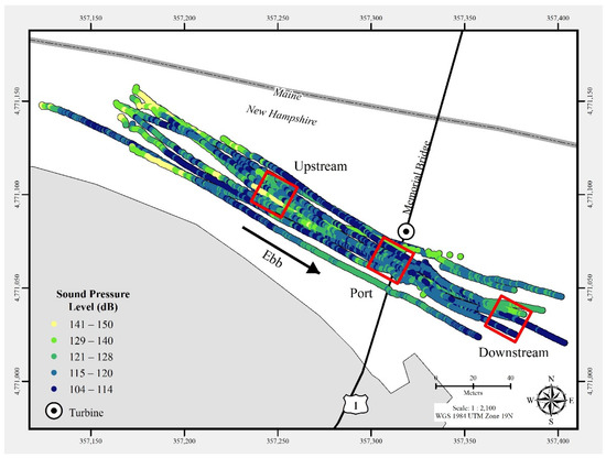
In July 2021, a commercial-off-the-shelf hydrophone was deployed in a free-drifting configuration to measure underwater acoustic emissions and characterize a 25 kW-rated tidal turbine at the...
-
The Digital Geologic Map of the Germanna Bridge Quadrangle, Virginia is comprised of GIS data layers, two ancillary GIS tables, a Windows Help File with ancillary map text, figures and tables, GIS...
-
<p>Decrease the number of structurally deficient bridges from 556 in 2013 to 280 by 2017.</p>
-
Bathymetric survey data were collected in December 2008 just south of Dumbarton Bridge in south San Francisco Bay, California. Portions of the main channel and western shallows/intertidal mudflats...
-
Bathymetric survey data were collected in April 2018 just south of Dumbarton Bridge in south San Francisco Bay, California. A portion of the main channel was surveyed using an interferometric...
-
Bathymetric survey data were collected in April 2013 just south of Dumbarton Bridge in south San Francisco Bay, California. A portion of the main channel was surveyed using an interferometric...
