
Search Data.gov
Found 13736 dataset(s) matching "acoustic".
-
The U.S. Geological Survey (USGS), in cooperation with the National Oceanic and Atmospheric Administration (NOAA) and the Massachusetts Office of Coastal Zone Management (MA CZM), is producing...
-
In 2010, the U.S. Geological Survey in Woods Hole, MA and St. Petersburg, FL, in partnership with the U.S. Army Corps of Engineers, Mobile District conducted geologic mapping to characterize the...
-
Following marine oil spills, weathered oil can mix with sediment in the surf zone and settle to the seafloor to form mats up to hundreds of meters long. Wave action fragments these mats into 1- to...
-
This dataset includes the discharge values and simulation input conditions for 9 simulation discharges at the Wallens Bend (WB) reach on the Clinch River near Kyles Ford, Tennessee. Simulations...
-
In 2006 and 2007, the U.S. Geological Survey, in partnership with Louisiana Department of Natural Resources and the University of New Orleans, conducted geologic mapping to characterize the sea...
-
In 2010, the U.S. Geological Survey in Woods Hole, MA and St. Petersburg, FL, in partnership with the U.S. Army Corps of Engineers, Mobile District conducted geologic mapping to characterize the...
-
The sidescan sonar image of the nearshore seafloor (0 to 100 m water depths) of the South Anacapa area was mosaicked from data collected in 1999 and 2000. A Klein 2000 sidescan system was used...
-
ADCP data were collected by sensors from seven deployments within 2004-2007 on the HALE-ALOHA mooring, a location about 100 km north of Oahu, Hawaii, USA. The HALE-ALOHA mooring supports the...
-
The sidescan sonar image of the nearshore seafloor (0 to 100 m water depths) of the Southeast Santa Cruz area was mosaicked from data collected in 1999. A Klein 2000 sidescan system was used for...
-
The U.S. Geological Survey (USGS), in cooperation with the Connecticut Department of Environmental Protection and National Oceanic and Atmospheric Administration (NOAA), is producing detailed...
-
Seafloor character, a combination of seafloor induration (surface hardness) and rugosity, was derived from multibeam echosounder (MBES) and annotated underwater video data collected offshore of...
-
This volume's release consists of 26141 media files captured by autonomous wildlife monitoring devices under the project, Indiana Dunes National Park. The attached files listed below include...
-
This dataset contains hydrographic data from 3 bottom-mounted moorings on the Amundsen Sea shelf from 2010-02-15 to 2014-01-24. The moorings each have an upward-looking ADCP located near the...
-
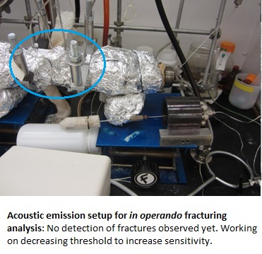
EGS field projects have not sustained production at rates greater than half of what is needed for economic viability. The primary limitation that makes commercial EGS infeasible is our current...
-
Metadata for the data collected at the NEES@UCSB Garner Valley Downhole Array field site on September 10-12, 2013 as part of the larger PoroTomo project.
-
This is a compilation of logs and data from Well 9-1 in the Roosevelt Hot Springs area in Utah. This well is also in the Utah FORGE study area. The file is in a compressed .zip format and there is...
-
Map of DAS, nodal, vibroseis and Reftek stations during March 2016 deployment. The plot on the left has nodal stations labeled; the plot on the right has vibroseis observations labeled. Stations...
-
This is the topical report that wraps up the work and results achieved during Utah FORGE Phase 2C. The zip file includes several folders containing (1) an overview; (2) the results; (3) the...
