
Search Data.gov
Found 3675 dataset(s) matching "well locations".
-
Dataset contains the groundwater well locations and water-level measurements for 273 wells measured during a water-level survey of the Sparta-Memphis aquifer in Arkansas, January through June...
-
This digital dataset contains datasets used to develop the Multi Node Well (MNW2) Package in CVHM2. It includes well locations, well properties for Municipal Pumping, Rural Pumping, Recovery...
-
This data release contains P- and S-wave velocity data from logs of nine wells in three large sedimentary basins in the San Francisco Bay region. The logs were collected between 2000 and 2006 for...
-
The High Plains aquifer extends from south of 32 degrees to almost 44 degrees north latitude and from 96 degrees 30 minutes to 104 degrees west longitude. The aquifer underlies about 175,000...
-
This is a compilation of logs and data from Well 52-21 in the Roosevelt Hot Springs area in Utah. This well is also in the Utah FORGE study area. The file is in a compressed .zip format and there...
-
This dataset contains a variety of data about the Fort Bliss geothermal area, part of the southern portion of the Tularosa Basin, New Mexico. The dataset contains schematic models for the...
-
Shallow (300 ft or less) coal exploration drill-hole data from 692 wells located in Arkansas are provided in this data release. The well locations extend over nine Arkansas counties and were...
-
This U.S. Geological Survey data release provides a comprehensive dataset of water-quality data and sampling-site characteristics collected in 1978–2018 during a study of the effects of land...
-
Groundwater arsenic concentrations in the San Joaquin Valley have varied over the decades from 1980 to 2019. This report was compiled to determine whether arsenic concentrations are increasing or...
-
The California State Water Resources Control Board (State Water Board) initiated the Regional Groundwater Monitoring Program (RMP) to assess effects of oil and gas development on groundwater...
-
In cooperation with the California State Water Resources Control Board’s oil and gas Regional Monitoring Program, the U.S. Geological Survey collected and analyzed groundwater and associated...
-
This submission includes an Excel spreadsheet containing the Utah FORGE deep well 16A(78)-32 planned trajectory including UTM coordinates, elevations, and depths from the well head to the toe....
-
The Chattanooga Shale is relatively thin and generally continuous across the state, making it an important geologic horizon. In Tennessee, the Chattanooga Shale crops out along the escarpment...
-
A cells polygon feature class was created by the U.S. Geological Survey (USGS) to illustrate the degree of exploration, type of production, and distribution of production in the State of Ohio. ...
-
Patua-ESRI Geodatabase (ArcGeology v1.3): - Contains all the geologic map data, including faults, contacts, folds, veins, dikes, unit polygons, and attitudes of strata and faults. - List of...
-
Water chemistry data from: Young, H.W., Parliman, D.J. and Mariner, R.H., 1988. Chemical and hydrologic data for selected thermal-water wells and non-thermal springs in the Boise Area,...
-
A cells polygon feature class was created by the U.S. Geological Survey (USGS) to illustrate the degree of exploration, type of production, and distribution of production in the State of Kentucky....
-
<div style='text-align:Left;'><p><span>This online map provides the locations of submitted Well Stimulation Permit records from CalGEM’s Well Statewide Tracking and Reporting System (WellSTAR)...
-
This digital dataset contains historical geochemical and other information for 45 samples of produced water from 38 sites in the Placerita and Newhall Oil Fields in Los Angeles County, southern...
-
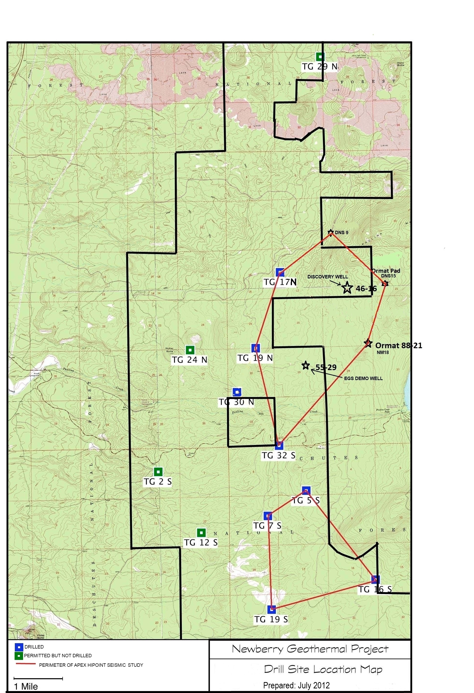
A map showing location of wells permitted, drilled and seismic test, as part of validation of innovative exploration technologies done for the Newberry Volcano project in 2012.
