
Search Data.gov
Found 272 dataset(s) matching "wave calibration".
-
Two digital video cameras were installed at Marconi Beach, Cape Cod National Seashore (CACO) in Massachusetts (MA) as part of a U.S. Geological Survey (USGS) research project to study the beach...
-
Two digital video cameras were installed at Marconi Beach, Cape Cod National Seashore (CACO) in Massachusetts (MA) as part of a U.S. Geological Survey (USGS) research project to study the beach...
-
Provides L1B high resolution (HR) short time critical (STC; 36-hour latency) altimetry data from the Poseidon-4 SAR altimeter on the Sentinel-6A Michael Freilich spacecraft which include the...
-
Provides reprocessed L1B high resolution (HR) non-time critical (NTC; 60-day latency) altimetry data from the Poseidon-4 SAR altimeter on the Sentinel-6A Michael Freilich spacecraft which include...
-
Provides L1A high resolution (HR) short time critical (STC; 36-hour latency) altimetry intermediate outputs from the Poseidon-4 SAR altimeter on the Sentinel-6A Michael Freilich spacecraft, which...
-
Provides reprocessed L1A high resolution (HR) non-time critical (NTC; 60-day latency) altimetry intermediate outputs from the Poseidon-4 SAR altimeter on the Sentinel-6A Michael Freilich...
-
This data set includes full resolution electric and magnetic wave spectra from the Galileo plasma wave receiver recorded during Jupiter orbital operations. In addition waveform survey data...
-
This data set includes full resolution electric and magnetic wave spectra from the Galileo plasma wave receiver recorded during Jupiter orbital operations. In addition waveform survey data...
-
This collection includes the Geophysical Data Record and other supporting data from the the US Navy GEOSAT Follow-On (GFO) operational radar altimeter satellite program. NOAA worked together with...
-
This data set provides estimates of Active Layer Thickness (ALT) determined with ground-based measurements, and calculated soil volumetric water content (VWC) at four selected sites around Barrow,...
-
The SWOT Level 2 KaRIn Low Rate Sea Surface Height Windwave Data Product from the Surface Water Ocean Topography (SWOT) mission provides global sea surface height and significant wave height...
-
The SWOT Level 2 KaRIn Low Rate Sea Surface Height Unsmoothed Data Product from the Surface Water Ocean Topography (SWOT) mission provides global sea surface height and significant wave height...
-
The SWOT Level 2 KaRIn Low Rate Sea Surface Height Expert Data Product from the Surface Water Ocean Topography (SWOT) mission provides global sea surface height and significant wave height...
-
The SWOT Level 2 KaRIn Low Rate Sea Surface Height Basic Data Product from the Surface Water Ocean Topography (SWOT) mission provides global sea surface height and significant wave height...
-
The SWOT Level 2 KaRIn Low Rate Sea Surface Height Basic Data Product from the Surface Water Ocean Topography (SWOT) mission provides global sea surface height and significant wave height...
-
The SWOT Level 2 KaRIn Low Rate Sea Surface Height Basic Data Product from the Surface Water Ocean Topography (SWOT) mission provides global sea surface height and significant wave height...
-
The SWOT Level 2 KaRIn Low Rate Sea Surface Height Data Product from the Surface Water Ocean Topography (SWOT) mission provides global sea surface height and significant wave height observations...
-
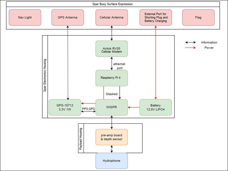
This data release is part of TEAMER RFTS 2, where the Cooperative Institute for Marine Resources Studies (CIMRS) at Oregon State University is performing hardware and software development and...
-
The MAVEN In-situ Calibrated Level 2, L2, Science Data Bundle contains selected fully calibrated Data from the Neutral Gas and Ion Mass Spectrometer, NGIMS, Instrument and the Particles and Fields...
