
Search Data.gov
Found 205 dataset(s) matching "Head Start".
-
<p dir="ltr"><b>Phenotypes_raw_sunflower_pericarp.xlsx</b><b> </b></p><p dir="ltr">Six tabs containing phenotypic data for sunflower pericarp, oil content, and banded sunflower moth damage...
-
In 2016, the U.S. Fish and Wildlife Service, U.S. Geological Survey, and U.S. Army Corps of Engineers undertook a large-scale interagency field study to determine the influence of commercial barge...
-
This part of DS 781 presents video observations from cruise F208NC in northern California. The vector data file is included in "f208nc_video_observations.zip," which is accessible from...
-
This part of DS 781 presents video observations from cruise L908NC for northern California. The vector data file is included in "l908nc_video_observations.zip," which is accessible from...
-
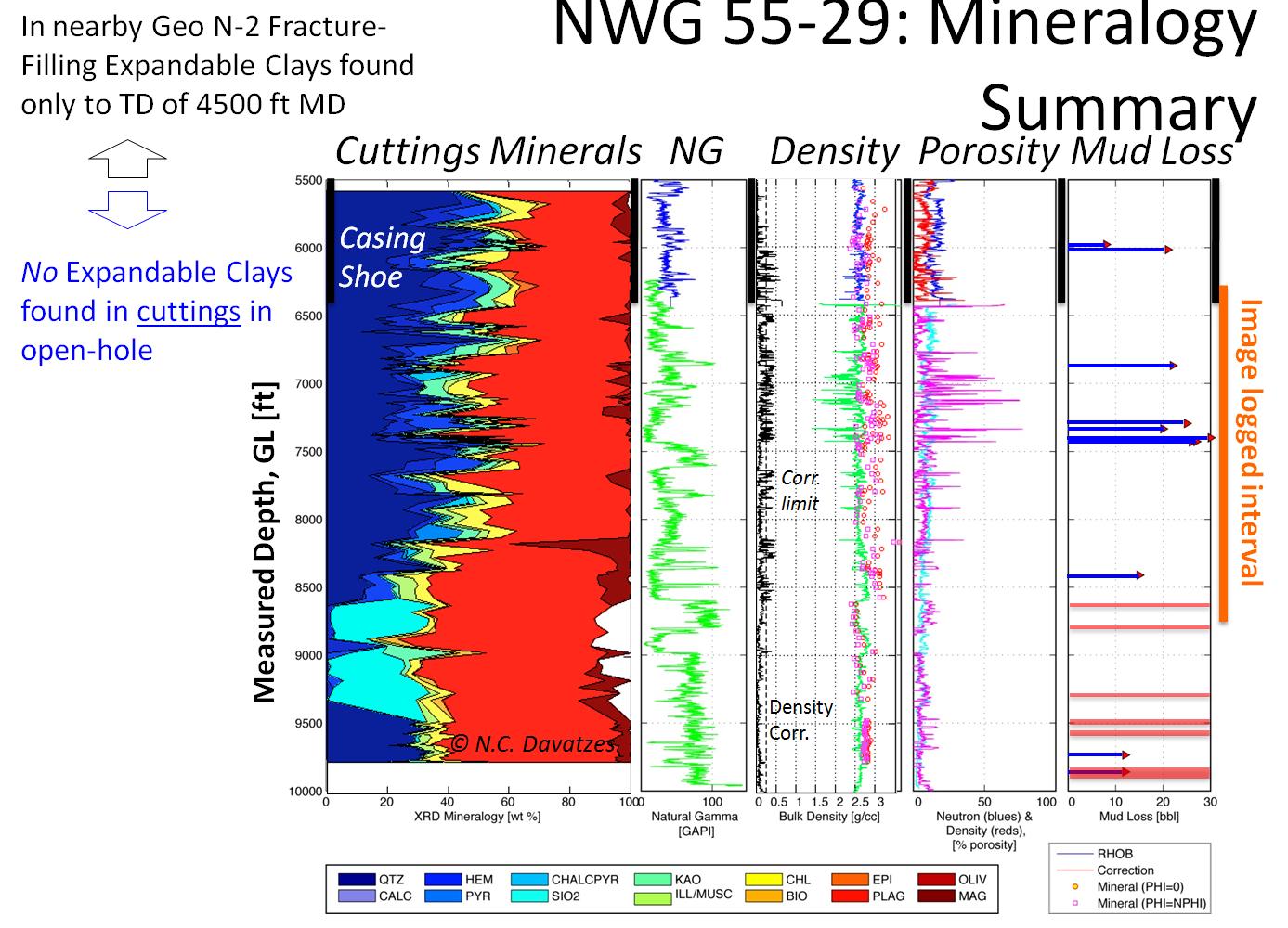
The Newberry Volcano EGS Demonstration in central Oregon, a 3 year project started in 2010, tests recent technological advances designed to reduce the cost of power generated by EGS in a hot, dry...
-
Whale data were collected using visual observations and other instruments in the Arctic Ocean from aircraft. Data were collected from 02 August 1979 to 18 October 1982 by the US Navy; Naval Ocean...
-
Individual Animal and other data were collected using visual observation and other instruments from AIRCRAFT in the Bering Sea, Chukchi Sea, and Arctic Ocean. Data were collected from 02 September...
-
Marine Mammal Sighting and Census data were collected from Coastal Alaska. Data were collected by Alaska Department of Fish and Game from 05 May 1985 to 13 June 1985. Data were processed by NODC...
-
Continuous measurements of nearshore currents in Lake Erie in the vicinity of Villa Angela Beach and Euclid Creek, Cleveland, Ohio, were recorded during the summer of 2019. Currents were measured...
-
Upon reactivation, movement of deep-seated landslides in the Greater Pittsburgh region may persist for long periods of time. Monitoring equipment was located at two sites on a deep-seated...
-
In 2016, the U.S. Fish and Wildlife Service, U.S. Geological Survey, and U.S. Army Corps of Engineers undertook a large-scale interagency field study to determine the influence of commercial barge...
-
This dataset contains underway measurements of pCO2, salinity, sea surface temperature, and other parameters collected in the Pacific ocean on the R/V Thomas G. Thompson in 2016. Cruise name:...
-
Data for Florida Straights Moorings CICESE. A program aimed at measuring the flows between the Gulf of Mexico and the North Atlantic Ocean, from Cuba to Florida, started on July 8, 2012, with the...
-
Data for Florida Straights Moorings CICESE. A program aimed at measuring the flows between the Gulf of Mexico and the North Atlantic Ocean, from Cuba to Florida, started on July 8, 2012, with the...
-
Data for Florida Straights Moorings CICESE. A program aimed at measuring the flows between the Gulf of Mexico and the North Atlantic Ocean, from Cuba to Florida, started on July 8, 2012, with the...
-
Data for Florida Straights Moorings CICESE. A program aimed at measuring the flows between the Gulf of Mexico and the North Atlantic Ocean, from Cuba to Florida, started on July 8, 2012, with the...
-
Data for Florida Straights Moorings CICESE. A program aimed at measuring the flows between the Gulf of Mexico and the North Atlantic Ocean, from Cuba to Florida, started on July 8, 2012, with the...
-
Data for Florida Straights Moorings CICESE. A program aimed at measuring the flows between the Gulf of Mexico and the North Atlantic Ocean, from Cuba to Florida, started on July 8, 2012, with the...
-
Data for Florida Straights Moorings CICESE. A program aimed at measuring the flows between the Gulf of Mexico and the North Atlantic Ocean, from Cuba to Florida, started on July 8, 2012, with the...
