
Search Data.gov
Found 879 dataset(s) matching "flow sample".
-
The Wilcox Oil Company Superfund site (hereinafter referred to as “the site”) was formerly an oil refinery in northeast of Bristow in Creek County, Oklahoma. Historical refinery operations...
-
Chemical, physical, profile, meteorological, navigational and underway oceanographic data were collected aboard NOAA Ship GORDON GUNTER in the Gulf of Mexico from 2010-08-24 to 2010-09-10 in...
-
U. S. Geological Survey (USGS) scientists completed a data collection campaign from the 26th of July to the 13th of August in 2021, using various methods to record geomorphic and habitat...
-
These data were used for an analysis as part of a long-term project monitoring the biological communities, habitat, and water quality of the Fountain Creek Basin. Biology, habitat, and water...
-
These data were used for an analysis as part of a long-term project monitoring the biological communities, habitat, and water quality of the Fountain Creek Basin. Biology, habitat, and water...
-
This dataset contains data collected during the Life on the Edge II (SJ0403) cruise, June 8-22, 2004, aboard the Harbor Branch Oceanographic Institution's research vessel Seward Johnson. The...
-
These data were used for an analysis as part of a long-term project monitoring the biological communities, habitat, and water quality of the Fountain Creek Basin. Biology, habitat, and water...
-
The North East 2nd Street Superfund site in Happy, Texas, overlies a groundwater plume of primarily carbon tetrachloride (CT) that is contained within an upper transmissive zone of the High Plains...
-
The Blue Ridge belt in northwestern North Carolina and northeastern Tennessee is composed chiefly of 1,000-million to 1,100-million-year-old metamorphic and plutonic rocks that have been thrust...
-
This dataset contains bulk tissue carbon (delta-13C), nitrogen (delta-15N), and sulfur (delta-34S) stable isotope values from sediment samples, marsh primary producers, marsh invertebrates, and...
-
**NOTICE: THIS VERSION OF REFPROP (9.1) has been superseded by Version 10: https://doi.org/10.18434/T4/1502528 ** NIST Standard Reference Data 23 contains revised data in a Windows version of the...
-
This section of the data release includes core log and spectrophotometry data in the format of a comma-separated value (CSV) file (2018LakePowellCoring_CoreLogData.csv). It is Part 3 (of four) in...
-
U. S. Geological Survey (USGS) scientists completed a data collection campaign from the 3rd of April to the 23rd of June in 2023, using various methods to record geomorphic and habitat indicators...
-
This section of the data release includes core and core section information in the format of a comma-separated value (CSV) file (2018LakePowellCoring_CoreSectionInfo.csv). It is Part 2 (of four)...
-
This data release contains a data compilation and analysis of the hydrogeology in the U.S. portion of the Lake Superior watershed, for the purpose of providing background data for future study and...
-
This dataset contains bulk tissue carbon (delta-13C) and nitrogen (delta-15N) stable isotope values from sediment samples, marsh primary producers, marsh invertebrates, and marsh vertebrates...
-
This data product contains soil chemistry data from 4 locations. Two of the locations were located in the Neversink River watershed near Claryville, NY (01435000) in the Catskill Mountains of New...
-
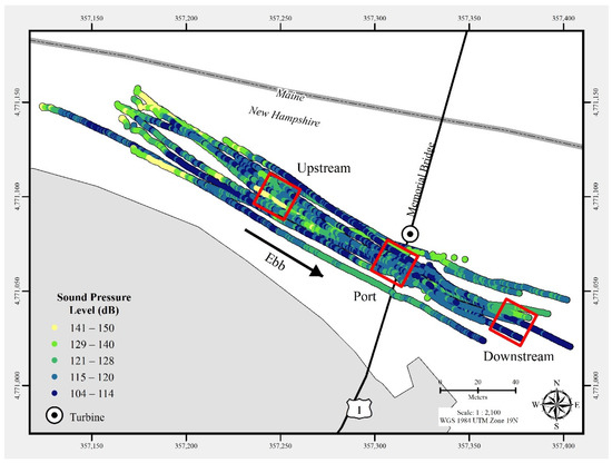
In July 2021, a commercial-off-the-shelf hydrophone was deployed in a free-drifting configuration to measure underwater acoustic emissions and characterize a 25 kW-rated tidal turbine at the...
-
**Overview** The ZephIR300 is a continuous wave LIDAR with a range of 10 m to 300 m. During HilFlowS the ZephIR300 was programmed to measure from 10 m to 150 m. In addition, the ZephIR300...
