
Search Data.gov
Found 94 dataset(s) matching "wb".
-
The GRIP DC-8 Meteorological measurement System (MMS) dataset was collected by the Meteorological Measurement System (MMS), which provides high-resolution, accurate meteorological parameters...
-
This dataset includes Level 1B (L1B) data products from the MODIS/ASTER Airborne Simulator (MASTER) instrument. The spectral data were collected during 23 flights aboard a NASA WB-57 aircraft over...
-
The Project Home to roughly one third of the Southeast's estuarine salt marsh acreage, South Carolina faces escalating local and state concerns over marsh vulnerability due to rising sea levels....
-
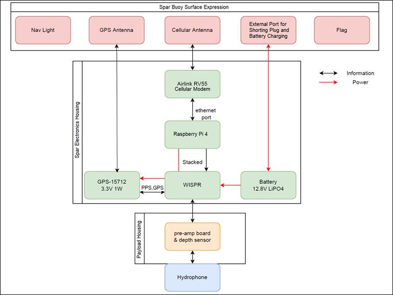
This data release is part of TEAMER RFTS 2, where the Cooperative Institute for Marine Resources Studies (CIMRS) at Oregon State University is performing hardware and software development and...
-
The GRIP High Altitude Imaging Wind and Rain Airborne Profiler (HIWRAP) dataset was collected by the High-Altitude Imaging Wind and Rain Airborne Profiler (HIWRAP), which is a dual-frequency (Ka-...
-
The actual evapotranspiration (AET) annual rates provided in shapefiles AET_SJR_Basin_Cells are for 2 km by 2 km cells in basins in east-central and northeast Florida. The AET rates are presented...
-
Actual evapotranspiration (AET) annual rates, from 2000 to 2017, for the Simplified Surface Energy Balance operational (SSEBop) method and from 2000 to 2016 for the land-cover based method,...
-
These data are the Goddard Satellite-based Surface Turbulent Fluxes Version-3 Dataset recently produced through a MEaSUREs funded project led by Dr. Chung-Lin Shie (UMBC/GEST, NASA/GSFC),...
-
This dataset includes the one-dimensional HEC-RAS model calibration files and simulation input and output files for the Wallens Bend (WB) reach on the Clinch River near Kyles Ford, Tennessee....
-
This dataset includes the discharge values and simulation input conditions for 9 simulation discharges at the Wallens Bend (WB) reach on the Clinch River near Kyles Ford, Tennessee. Simulations...
-
The U.S. Inland Creel and Angler Survey Catalog (CreelCat) contains data compiled from 14,766 creel and angler surveys conducted by state natural resource management agencies (including Washington...
-
The U.S. Inland Creel and Angler Survey Catalog (CreelCat) contains data compiled from 14,729 creel and angler surveys conducted by state natural resource management agencies (including Washington...
-
Since 2005, the U.S. Geological Survey - Great Lakes Science Center's Lake Erie Biological Station (LEBS) has participated in a collaborative, multiagency effort to assess pelagic prey fish...
-
This dataset includes Level 1B (L1B) data products from the MODIS/ASTER Airborne Simulator (MASTER) instrument. The spectral data were collected during 14 flights aboard a NASA WB-57 aircraft over...
-
The Tropical Cyclone Intensity (TCI) Hurricane Imaging Radiometer (HIRAD) dataset was created for the TCI field campaign from August 30, 2015 through October 23, 2015. The goal of the TCI field...
