
Search Data.gov
Found 988 dataset(s) matching "production zone".
-
The files linked to this reference are the geospatial data created as part of the completion of the baseline vegetation inventory project for the NPS park unit. Current format is ArcGIS file...
-
Nutrients, physical, and other data were collected using bottle and CTD casts in the Atlantic Ocean, Indian Ocean, Mediterranean Sea, and Bay of Biscay from 01 January 1989 to 30 April 2003. Data...
-
Dataset contains a polygon shapefile representing poultry houses in the Upper Choptank watershed in Queen Anne's County, Maryland, and Kent County, Delaware.
-
This database contains coincident profiles of primary productivity and downwelling radiance spectra obtained in the South China Sea. These data were taken at stations occupied within 15-23° N and...
-
The objective of this ongoing study is to investigate how pulses of precipitation translate into pulses of plant aboveground net primary productivity (NPP) across grassland to shrubland ecotones...
-
Between 6 November and 12 December 1988, vertical distributions of Calanus finmarchicus, C. hyperboreus, C. glacialis and Metridia long were studied at three stations in the Arctic water of the...
-
The sand shoals (modeled) polygons represent the hypothesized distribution of sand shoals of the Gulf of Mexico and US Atlantic Coast based on seafloor characteristics and distance to shoreline...
-
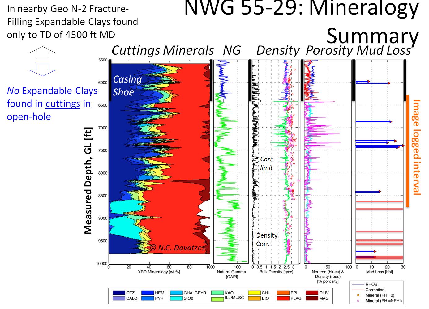
In enhanced geothermal systems (EGS) the reservoir permeability is often enhanced or created using hydraulic fracturing. In hydraulic fracturing, high fluid pressures are applied to confined...
-
The LANDFIRE vegetation layers describe the following elements of existing and potential vegetation for each LANDFIRE mapping zone: environmental site potentials, biophysical settings, existing...
-
The Newberry Volcano EGS Demonstration in central Oregon, a 3 year project started in 2010, tests recent technological advances designed to reduce the cost of power generated by EGS in a hot, dry...
-
The Newberry Volcano EGS Demonstration in central Oregon, a 5 year project begun in 2010, tests recent technological advances designed to reduce the cost of power generated by EGS in a hot, dry...
-
These datasets support the conclusions in the journal article entitled "National population exposure and evacuation potential in the United States to earthquake-generated tsunami threats " as...
-
This package includes data and footage from two rounds of downhole camera surveys performed at the Sanford Underground Research Facility (SURF) on the 4850 level. The exercise was performed once...
-
The files linked to this reference are the geospatial data created as part of the completion of the baseline vegetation inventory project for the NPS park unit. Current format is ArcGIS file...
-
SAMSN7L3ZMTG is the Nimbus-7 Stratospheric and Mesospheric Sounder (SAMS) Level 3 Zonal Means Composition Data Product. The Earth's surface is divided into 2.5-deg latitudinal zones that extend...
