
Search Data.gov
Found 3043 dataset(s) matching "lived".
-
This dataset contains short-lived radioisotope (SLRad), sediment core photographs, and bulk density/porewater data from sediment cores collected aboard R/V Weatherbird II cruises WB-0813 and...
-
Assisted Living Service Agencies derived from Licenses and Credentials recorded in Connecticut's eLicensing system. This dataset is pulled from the full State Licenses and Credentials dataset:...
-
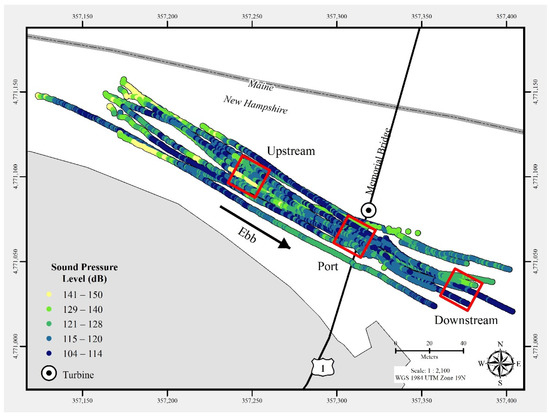
In July 2021, a commercial-off-the-shelf hydrophone was deployed in a free-drifting configuration to measure underwater acoustic emissions and characterize a 25 kW-rated tidal turbine at the...
-
This dataset contains CTD, short-lived radioisotope (SLRad), sediment sample location data, and other sediment data types obtained from sediment cores collected aboard R/V Weatherbird cruise...
-
This dataset contains the concentration of polycyclic aromatic hydrocarbon (PAHs) and biomarkers (hopanes, steranes, alkanes) in marine sediment cores using gas chromatography-mass spectrometry...
-
This dataset contains the Live Well Report monthly data that reflects wellness enrollment and engagement in the Virgin Pulse Program (corporate wellness programs that are designed to support and...
-
<p>The primary objective of the National Pregnancy and Health<br /> Survey (NPHS) was to produce national annual estimates of the<br /> percentages and numbers of mothers of live newborns in the...
-
This dataset lists licensed assisted living facilities in Montgomery County, MD. The dataset provides each facility’s address, phone number, and geographic coordinates, as well as the facility’s...
-
Background To maintain organelle integrity, resident proteins must segregate from itinerant cargo during secretory transport. However, Golgi resident enzymes must have intimate access to...
-
These data represent laboratory reflectance measurements conducted on a suite of sandstone, tuffaceous mudstone and claystone rocks and sediment, which are known host and source materials for roll...
-
A digital elevation map (also known as a Digital Elevation Model, or DEM) of the Naval Live Oaks Area in Florida's Gulf Islands National Seashore was produced from remotely sensed, geographically...
-
This dataset contains short-lived radioisotope (SLRad), sediment core photographs, and bulk density/porewater data from sediment cores collected aboard R/V Weatherbird II and R/V Justo Sierra...
-
This is the original (1992) Gulf of Mexico regional component of NOAA's Estuarine Living Marine Resources (ELMR) Project, a national database of ecologically and economically important fishes and...
-
This is the original (1991) Southeast regional component of NOAA's Estuarine Living Marine Resources (ELMR) Project, a national database of ecologically and economically important fishes and...
-
Best management practice for living shoreline armoring in Lake Pontchartrain, Louisiana, based on Shoreline Management Model (SMM) V5.1 model created by Virginia Institute of Marine Science,...
-
This dataset contains measured (interval=20 minutes) current velocity during February 1 to April 4, 2018 at seven locations along the Gandy's Beach, New Jersey in upper Delaware Bay. These data...
-
Records of mule deer found dead or live captured on the northern Yellowstone winter range, 1993-1997
The data detail the live captures and radio-collaring of female mule deer on the northern Yellowstone winter range - 60 in 1993 and 25 in 1995 - and details of the known deaths of these deer. It...
-
This is the West Coast regional component of NOAA’s Estuarine Living Marine Resources (ELMR) Project, a national database of ecologically and economically important fishes and invertebrates in the...
