
Search Data.gov
Found 95 dataset(s) matching "kriging".
-
We performed bathymetric surveys using a shallow-water echo-sounding system (Takekawa et al., 2010, Brand et al., 2012) comprised of an acoustic profiler (Navisound 210; Reson, Inc., Slangerup,...
-
We performed bathymetric surveys using a shallow-water echo-sounding system (Takekawa et al., 2010, Brand et al., 2012) comprised of an acoustic profiler (Navisound 210; Reson, Inc., Slangerup,...
-
The research was conducted at nine tidal marshes in coastal estuaries spanning the Washington and Oregon coastlines from Padilla Bay in northern Washington to Bandon located at the mouth of the...
-
The research was conducted at nine tidal marshes in coastal estuaries spanning the Washington and Oregon coastlines from Padilla Bay in northern Washington to Bandon located at the mouth of the...
-
To assess the current topography of the tidal marshes we conducted survey-grade elevation surveys at all sites between 2009 and 2013 using a Leica RX1200 Real Time Kinematic (RTK)Global...
-
To assess the current topography of tidal marsh at the study sites we conducted survey-grade global positioning system (GPS) surveys between 2009 and 2014 using a Leica RX1200 Real Time Kinematic...
-
Correlation of flows at pairs of streamgages were evaluated using a Spearman’s rho correlation coefficient to better identify gages that can be used as index gages to estimate daily flow at...
-
These rasters represent plant cover during each of the first five growing seasons after fire in the area burned in the 2015 Soda wildfire. Specifically included cover layers are annual herbaceous,...
-
This dataset contains point features, line features, and raster grids that together constitute a 3D structural model of the northern Arkoma basin and southern Ozark dome in Arkansas, USA. Point...
-
This digital dataset was created as part of a U.S. Geological Survey study in cooperation with the Santa Barbara County Water Agency to conduct a hydrologic resource assessment and develop an...
-
This dataset is the estimated altitude of the top of the uppermost fine-grained sediment within the Wood River Valley aquifer system. This map was compiled by describing the estimated altitude...
-
The U.S. Geological Survey (USGS) used the Borehole data to characterize the hydrogeology in the Central Valley of California for the updated Central Valley Hydrologic Model (CVHM2). These data...
-
The Sediment and Aquifer Characteristics dataset includes two, grid-based polygon feature classes. The first class uses a five-kilometer grid to show the density of lithologic logs available for...
-
This data release comprises the tabular data used to develop regression equations for estimating selected low-flow statistics for ungaged streams in Ohio that are not substantially affected by...
-
Correlation of flows at pairs of streamgages were evaluated using a Spearman’s rho correlation coefficient to better identify gages that can be used as index gages to estimate daily flow at...
-
Gridded carbon dioxide mole fraction (XCO2) and other select variables created by applying local kriging (also known as optimal interpolation) to daily aggregates of Orbiting Carbon Observatory...
-
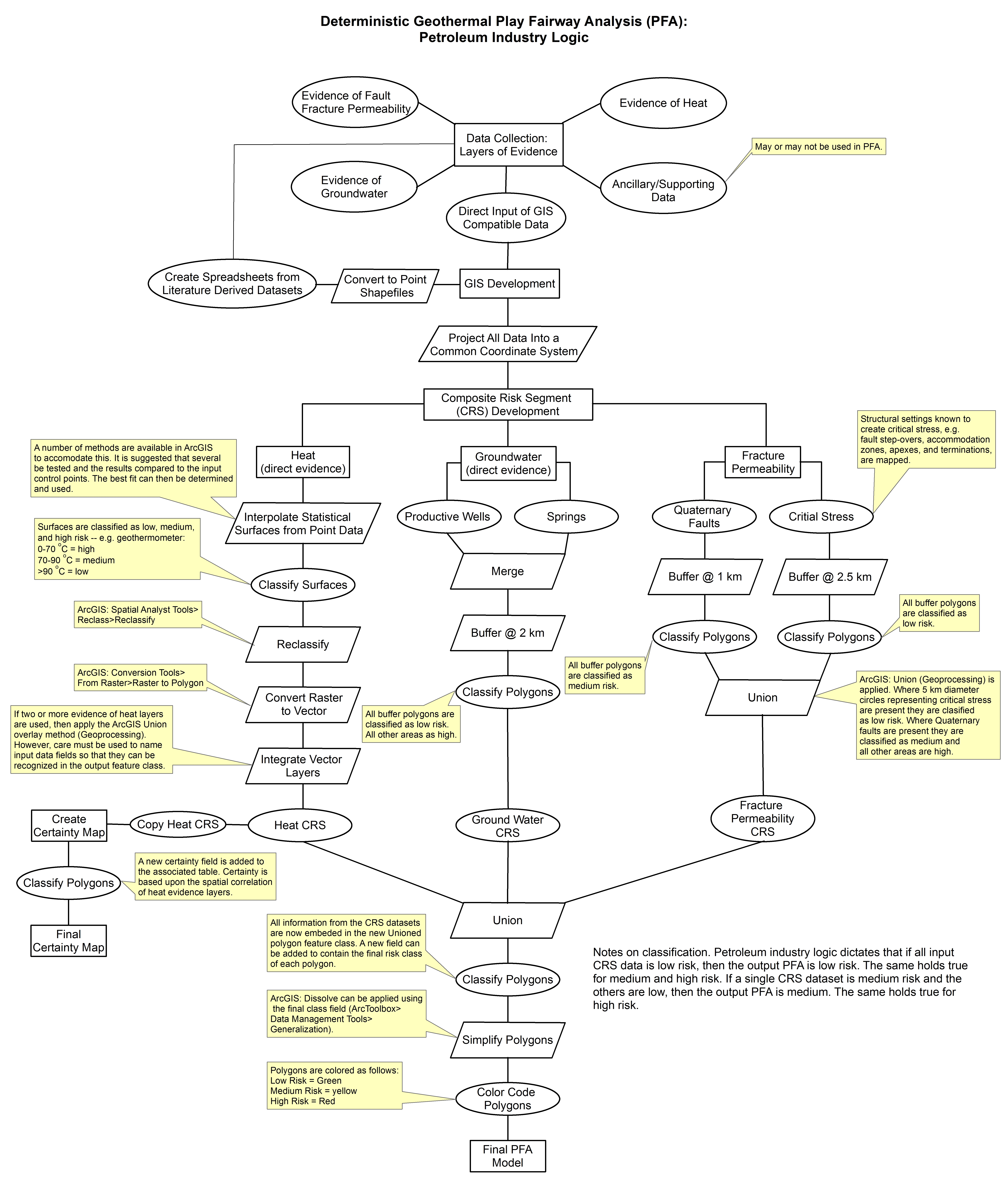
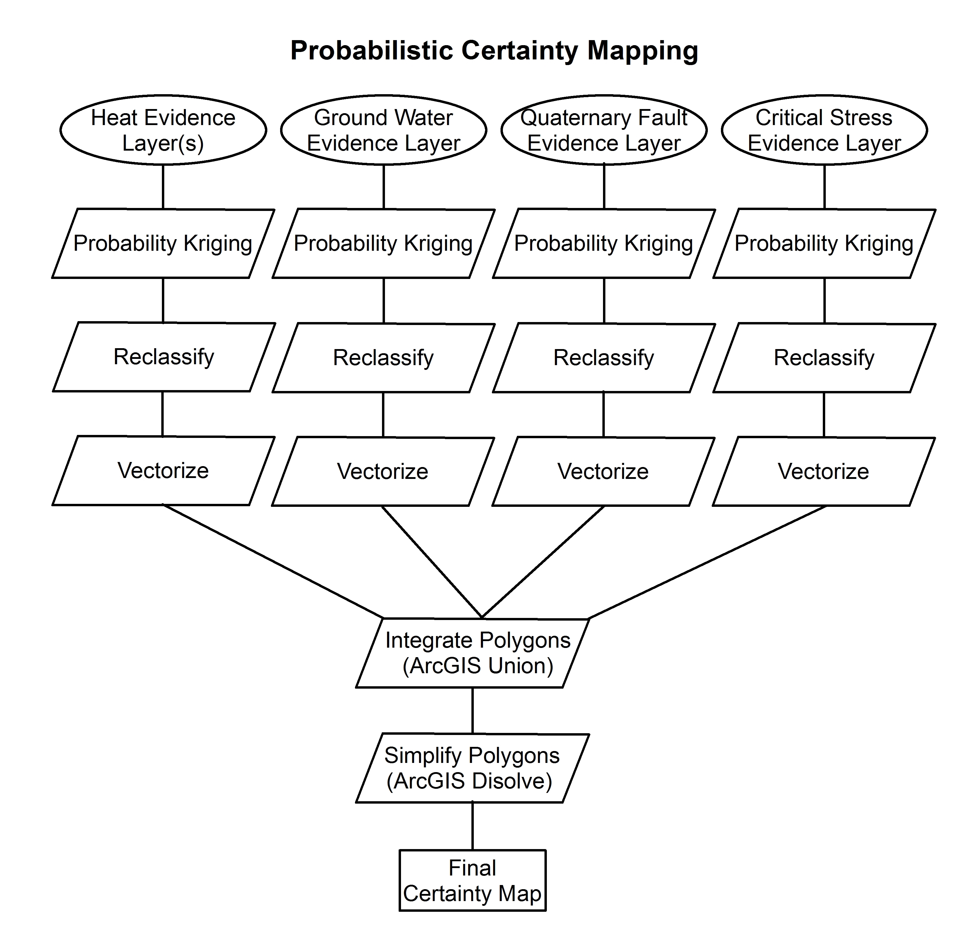
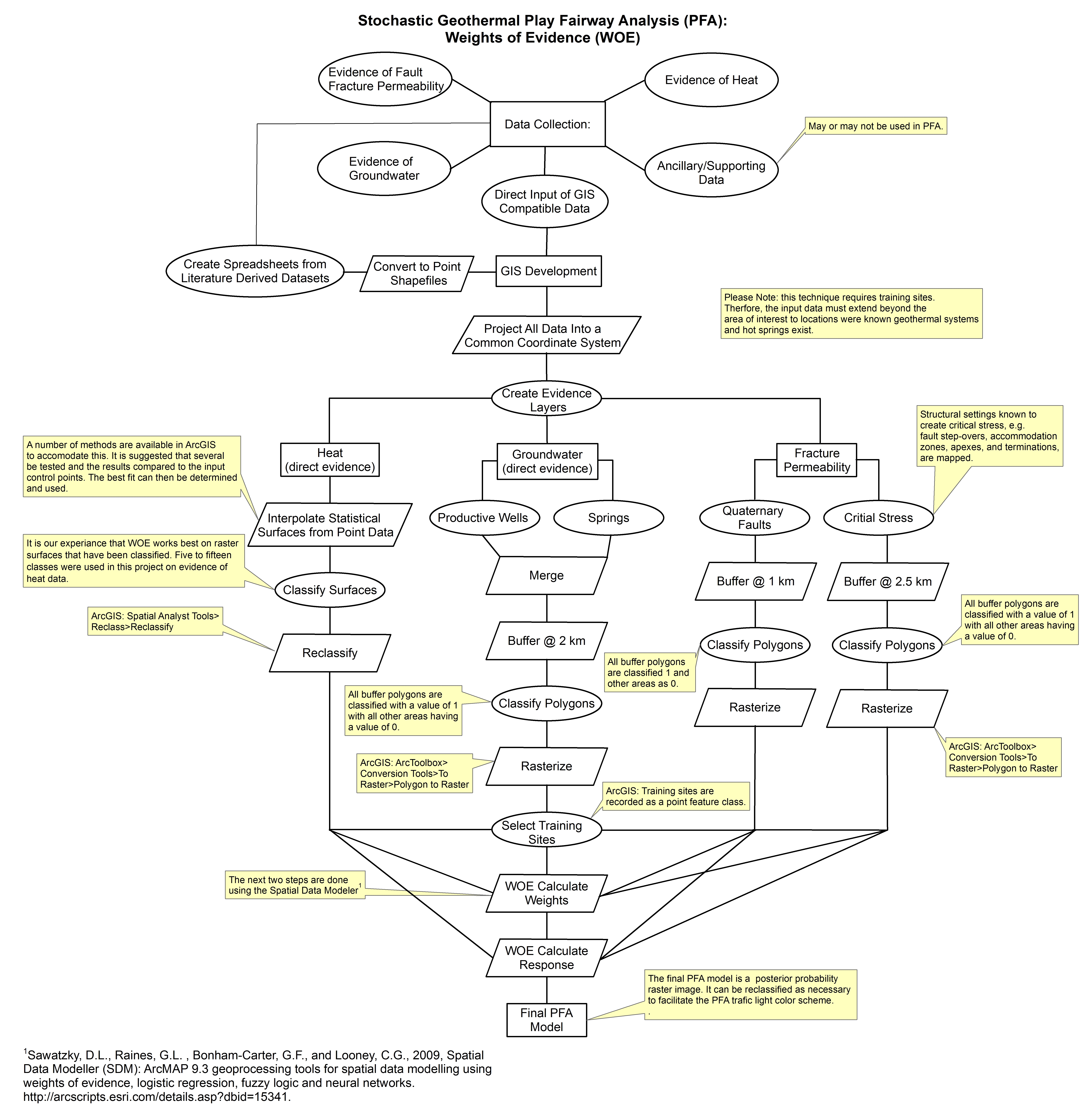
These images show the comprehensive methodology used for creation of a Play Fairway Analysis to explore the geothermal resource potential of the Tularosa Basin, New Mexico. The deterministic...
-
The product data are six statistics that were estimated for the chemical concentration of lithium in the soil C horizon of the conterminous United States. The estimates are made at 9998 locations...
-
This data release contains groundwater elevation data and the associated model/code used to create groundwater elevation surfaces in and around select oil fields in California. The data and model...
