
Search Data.gov
Found 202 dataset(s) matching "conceptual model".
-
These data are part of NACJD's Fast Track Release and are distributed as they were received from the data depositor. The files have been zipped by NACJD for release, but not checked or processed...
-
Des Moines Water Works (DMWW) is a regional municipal water utility that supplies residential and commercial water resources to about 600,000 customers in Des Moines, Iowa, and surrounding...
-
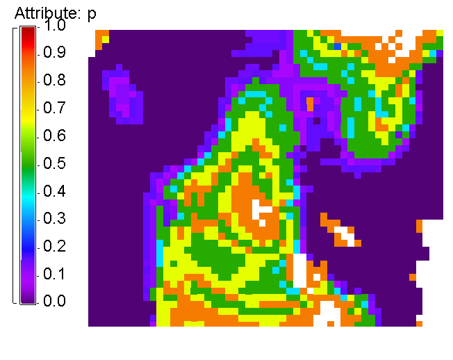
The PoroTomo team has completed inverse modeling of the three data sets (seismology, geodesy, and hydrology) individually, as described previously. The estimated values of the material properties...
-
The mid-Piacenzian is known as a period of relative warmth when compared to the present day. A comprehensive understanding of conditions during the Piacenzian serves as both a conceptual model and...
-
A new groundwater flow model for western Chippewa County, Wisconsin has been developed by the Wisconsin Geological and Natural History Survey (WGNHS) and the U.S. Geological Survey (USGS). An...
-
The California Current Integrated Ecosystem Assessment (CCIEA) is a joint project between staff at the NWFSC, SWFSC, NMML, ONMS, and WCRO to provide managers and policy makers with integrated...
-
This is the topical report that wraps up the work and results achieved during Utah FORGE Phase 2C. The zip file includes several folders containing (1) an overview; (2) the results; (3) the...
-
The U.S. Geological Survey is studying Lake Koocanusa, a border reservoir between British Columbia in Canada and Montana, in collaboration with the Montana Department of Environmental Quality and...
-
This data release consists of three different types of geoelectric data measured along three curvilinear profiles during two separate geophysical surveys completed on July 9, 2017 and January 9,...
-
Sea otters are well-known tool users, employing objects such as rocks or shells to break open invertebrate prey. We used a series of generalized linear mixed effect models (GLMEs) to examine...
-
These histograms represent our calibration of conductance of a volcanic geothermal field (with a clay cap) and the observed steam flow rates. Darajat is a vapor geothermal field located in West...
-
In 1999, the U.S. Geological Survey (USGS), in partnership with the South Carolina Sea Grant Consortium, began a study to investigate processes affecting shoreline change along the northern coast...
-
In 1999, the U.S. Geological Survey (USGS), in partnership with the South Carolina Sea Grant Consortium, began a study to investigate processes affecting shoreline change along the northern coast...
-
In 1999, the USGS, in partnership with the South Carolina Sea Grant Consortium, began a study to investigate processes affecting shoreline change along the northern coast of South Carolina,...
-
In 1999, the USGS, in partnership with the South Carolina Sea Grant Consortium, began a study to investigate processes affecting shoreline change along the northern coast of South Carolina,...
-
In 1999, the U.S. Geological Survey (USGS), in partnership with the South Carolina Sea Grant Consortium, began a study to investigate processes affecting shoreline change along the northern coast...
-
In 1999, the USGS, in partnership with the South Carolina Sea Grant Consortium, began a study to investigate processes affecting shoreline change along the northern coast of South Carolina,...
-
In 1999, the U.S. Geological Survey (USGS), in partnership with the South Carolina Sea Grant Consortium, began a study to investigate processes affecting shoreline change along the northern coast...
-
In 1999, the USGS, in partnership with the South Carolina Sea Grant Consortium, began a study to investigate processes affecting shoreline change along the northern coast of South Carolina,...
