
Search Data.gov
Found 625 dataset(s) matching "Well Logs".
-
This dataset contains velocity and flow log data collected in 2004 for two Yucaipa Valley Water District (YVWD) public-supply wells, YVWD 55 and YVWD 56. Data were collected using the tracer-pulse...
-
This zipped data set includes Schlumberger FMI logs DLIS and XML files from Utah FORGE deep well 58-32. These include runs 1 (2226-7550 ft) and 2 (7440-7550 ft). Run 3 (7390-7527ft) was acquired...
-
A Schlumberger Fullbore Formation Micro-Imager (FMI) log was run from 7390 feet to 7527 feet depth in well 58-32, originally known as well MU-ESW1. Well 58-32 was completed in 2017 as part of Utah...
-
An extensive archive containing more than 10,000 historical (1918–2020) geophysical logs collected in conjunction with studies done by various entities and more than 2,000 additional donated well...
-
This dataset contains Schlumberger dip meter and neutron density logs for Lu Lu State #1 wild cat well which is located in the Beaver Basin, Beaver County, Utah. There is also a text file with...
-
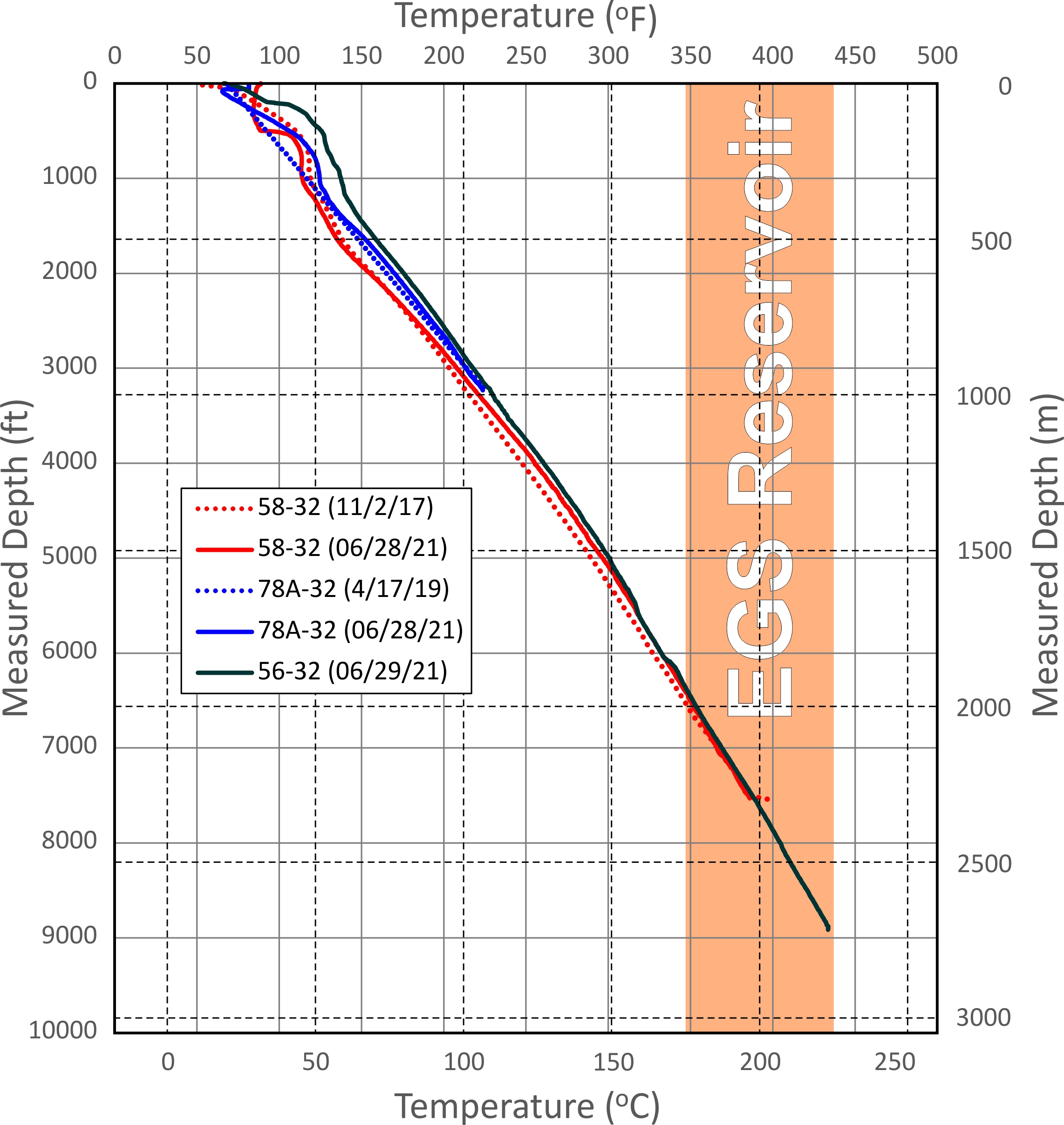
This dataset includes updated temperature and pressure logs for Utah FORGE wells 56-32, 78-32, and 58-32. This data was acquired in June 2021.
-
The data within this page contain .csv files with caliper, natural gamma, resistivity, fluid temperature, fluid specific conductance, and heat-pulse flow measurements (ambient and stressed conditions).
-
The data within this page contain .csv files with caliper, natural gamma, resistivity, fluid temperature, fluid specific conductance, and heat-pulse flow measurements (ambient and stressed conditions).
-
The data within this page contain .csv files with caliper, optical, acoustic, and tadpole plots of structure measurements.
-
This submission contains the following data associated with Utah FORGE Phase 2C within the Roosevelt Hot Springs geothermal area: - An ArcGIS shapefile with well locations for wells 58-32, 78-32,...
-
This dataset consists of Baker Hughes Pressure-Temperature gauge readings on fiber optics in Utah FORGE Well 16B(78)-32. This gauge is at a measured depth of 7,056.67 feet. The true vertical depth...
-
Mud logs for wells 83-11, 68-6, 33A-7, 33A-7RD, 52B-7, and 88-1 at West Flank
-
This dataset provides well construction information provided by driller well logs. Well logs can be accessed on the Minnesota Well Index online (http://www.health.state.mn.us/ divs/eh/cwi/).
-
The U.S. Geological Survey (USGS) compiled and analyzed data for mapping groundwater total dissolved solids (TDS) at the San Ardo Oil Field in Monterey County, California. Data include groundwater...
-
In order to gather data to assess sedimentary geothermal feasibility in Nevada and Utah, state oil and gas and geothermal databases were serached for well files and well logs. Well data from the...
-
In 2006, a cooperative study was established to compile reliable data describing groundwater and surface-water interactions in the Elkhorn and Loup River Basins. The purpose of the study was to...
-
This archive consists of a pdf graphic log and a LAS text file representing the results of the pressure and temperature logs measured on Nov. 8th, 2018 from the Utah FORGE deep test well 58-32...
