
Search Data.gov
Found 43 dataset(s) matching "Utah Play Fairway".
-
Tularosa Basin Play Fairway Analysis: Modeled MT Resistivity Data for the McGregor Range, New Mexico
This is the inversion resistivity data from a magnetotelluric survey done as part of Phase 2 Tularosa Basin, New Mexico, geothermal play fairway analysis. The data covers part of McGregor Range,...
-
This dataset contain raw data files in kmz files (Google Earth georeference format). These files include volcanic vent locations and age, the distribution of fine-grained lacustrine sediments...
-
This report details all of the work done in Phase 2 of a geothermal exploration project in Tularosa Basin, New Mexico. Data acquired as part of Phase 2 includes field geology (geological...
-
This is a hydrothermal alteration map of the Tularosa Basin area, New Mexico and Texas that was created using Advanced Spaceborne Thermal Emission and Reflection Radiometer (ASTER) multispectral...
-
This submission contains multiple excel spreadsheets and associated written reports. The datasets area are representative of shallow temperature, geochemistry, and other well logging observations...
-
This report describes all of the work done in Phase I of a geothermal exploration project in the Tularosa Basin, as well as an outline for Phase II work, and more.
-
Tularosa Basin Play Fairway Analysis: Partial Basin and Range Heat and Zones of Critical Stress Maps
Interpolated maps of heat flow, temperature gradient, and quartz geothermometers are included as TIF files. Zones of critical stress map is also included as a TIF file. The zones are given a 5km...
-
This submission has two shapefiles and a tiff image. The weights of evidence analysis was applied to data representing heat of the earth and fracture permeability using training sites around the...
-
This submission includes a fault map of the Oregon Cascades and backarc, a probability map of heat flow, and a fault density probability layer. More extensive metadata can be found within each zip...
-
This is a digitized geologic map, in shapefile format, including rock unit lithological descriptions, faults, and dikes.
-
This shapefile contains 409 well data points on Tularosa Basin Water Chemistry, each of which have a location (UTM), temperature, quartz and Potassium/Magnesium geothermometer; as well as...
-
A DEM of the Tularosa Basin was divided into twelve zones, each of which a ZR ratio was calculated for. This submission has a TIFF image of the zoning designations, along with a table with...
-
This comprehensive magnetotellurics (MT) dataset, which covers southwestern Utah, integrates 600 sites from various surveys, including those from the Utah FORGE, SubTER, and Play Fairway projects,...
-
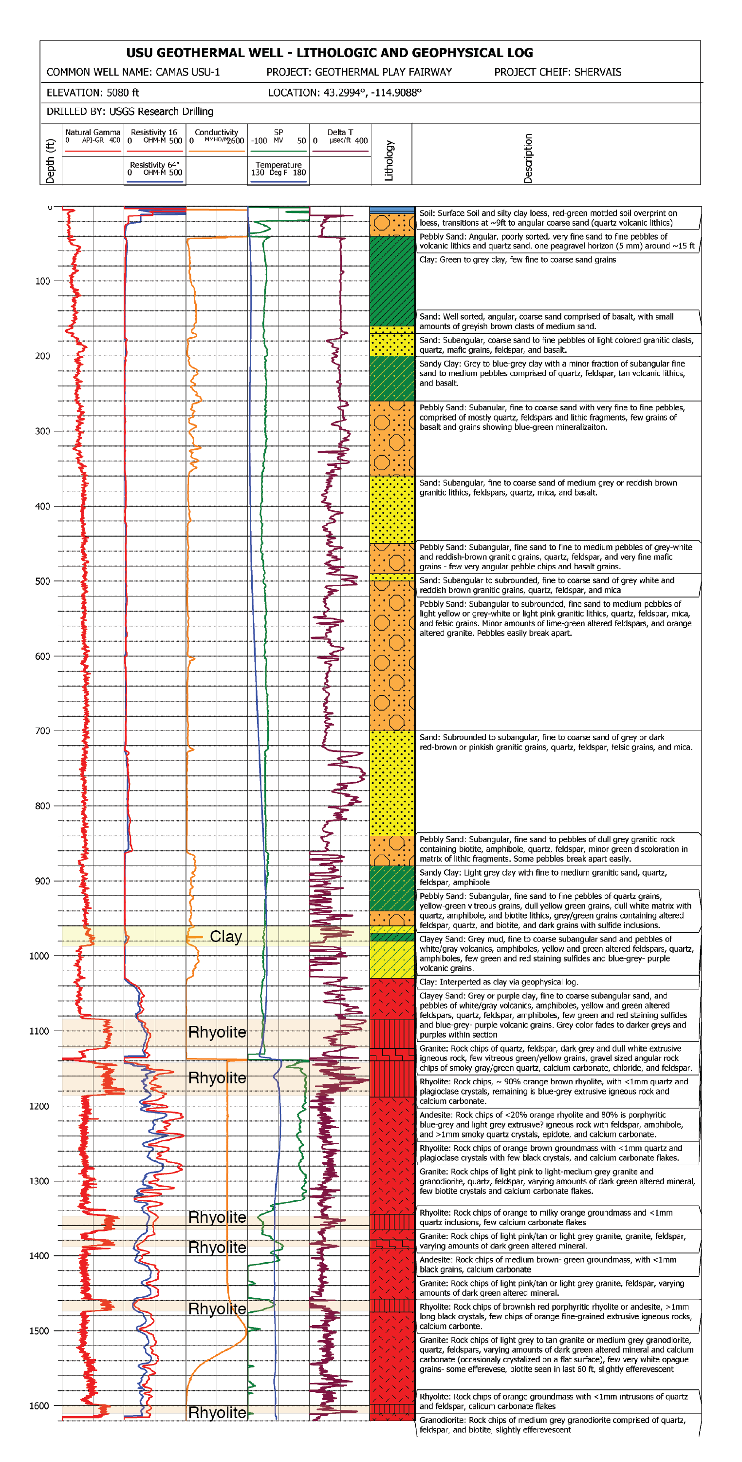
USU Camas-1 is a geothermal test well drilled in Camas Prairie, Idaho, in the Summer and Fall of 2018. The purpose of this test well was to validate Play Fairway methodologies of the Snake River...
-
DEEPEN stands for DE-risking Exploration of geothermal Plays in magmatic ENvironments. As part of the development of the DEEPEN 3D play fairway analysis (PFA) methodology for magmatic plays...
-
This dataset includes chemistry of geothermal water samples of the Camas Prairie area in Idaho. The samples included in this dataset were collected over the period of 2016-2019....
