
Search Data.gov
Found 43 dataset(s) matching "Petroleum Exploration".
-
This feature class was created to assemble oil and gas well information for a comprehensive inventory of energy data pertinent to the Wyoming Landscape Conservation Initiative decision-making...
-
This coverage includes arcs, polygons and polygon labels that describe U.S. Geological Survey defined geologic provinces of Europe including Turkey. (Albania, Andorra, Austria, Belgium, Bosnia and...
-
This presents the results of Phase 1 of the Snake River Plain Play Fairway Analysis project, along with a proposed work for Phase 2. No new data were collected, but we list data sources for our...
-
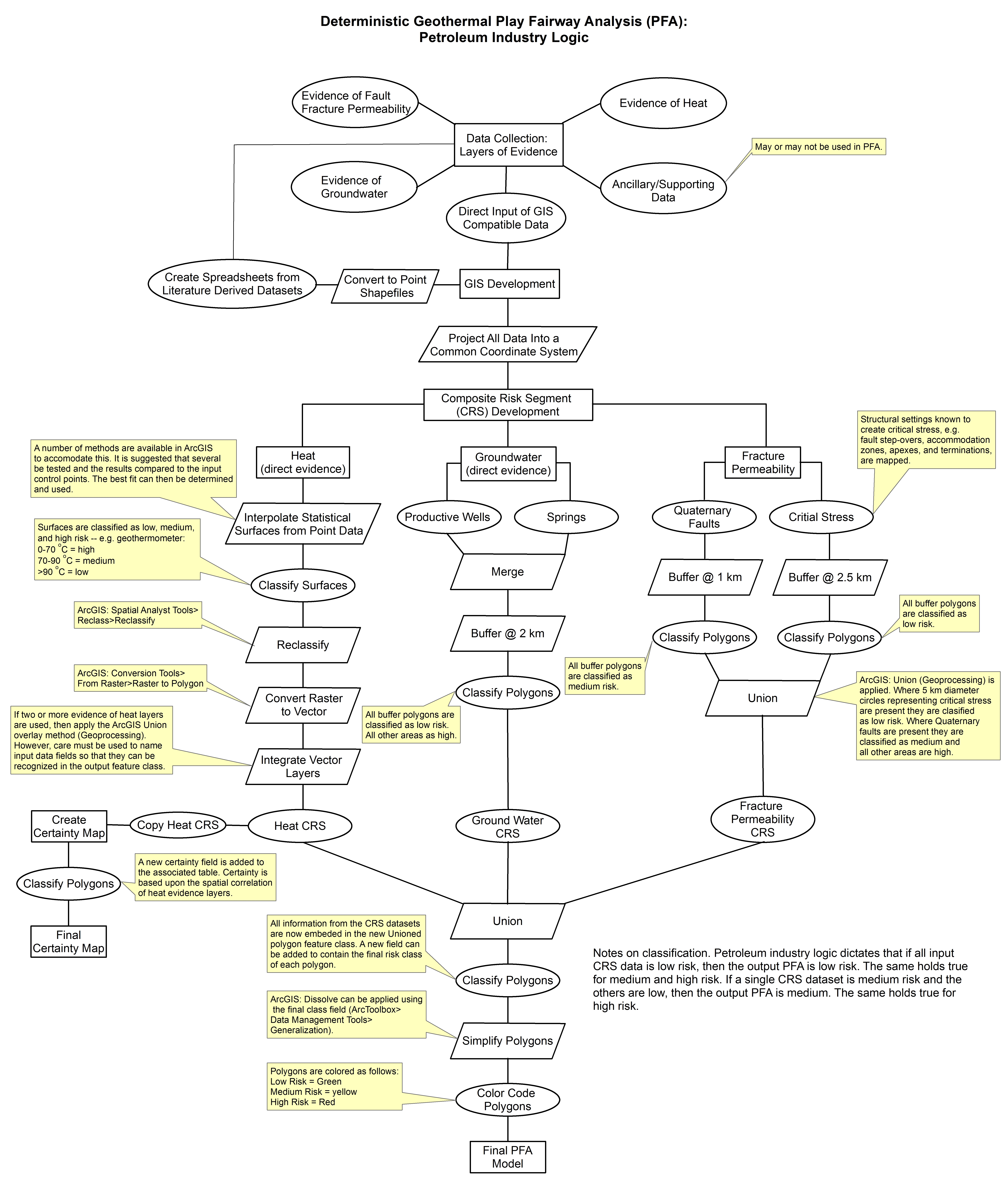
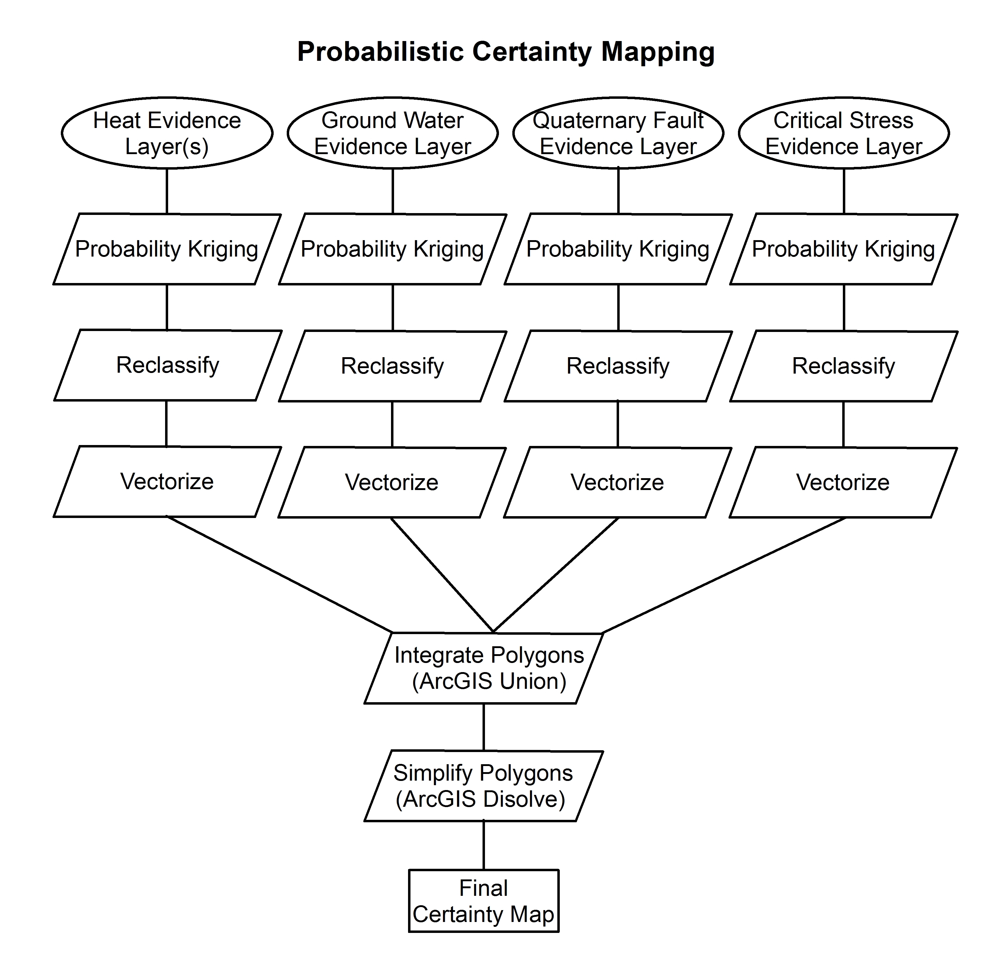
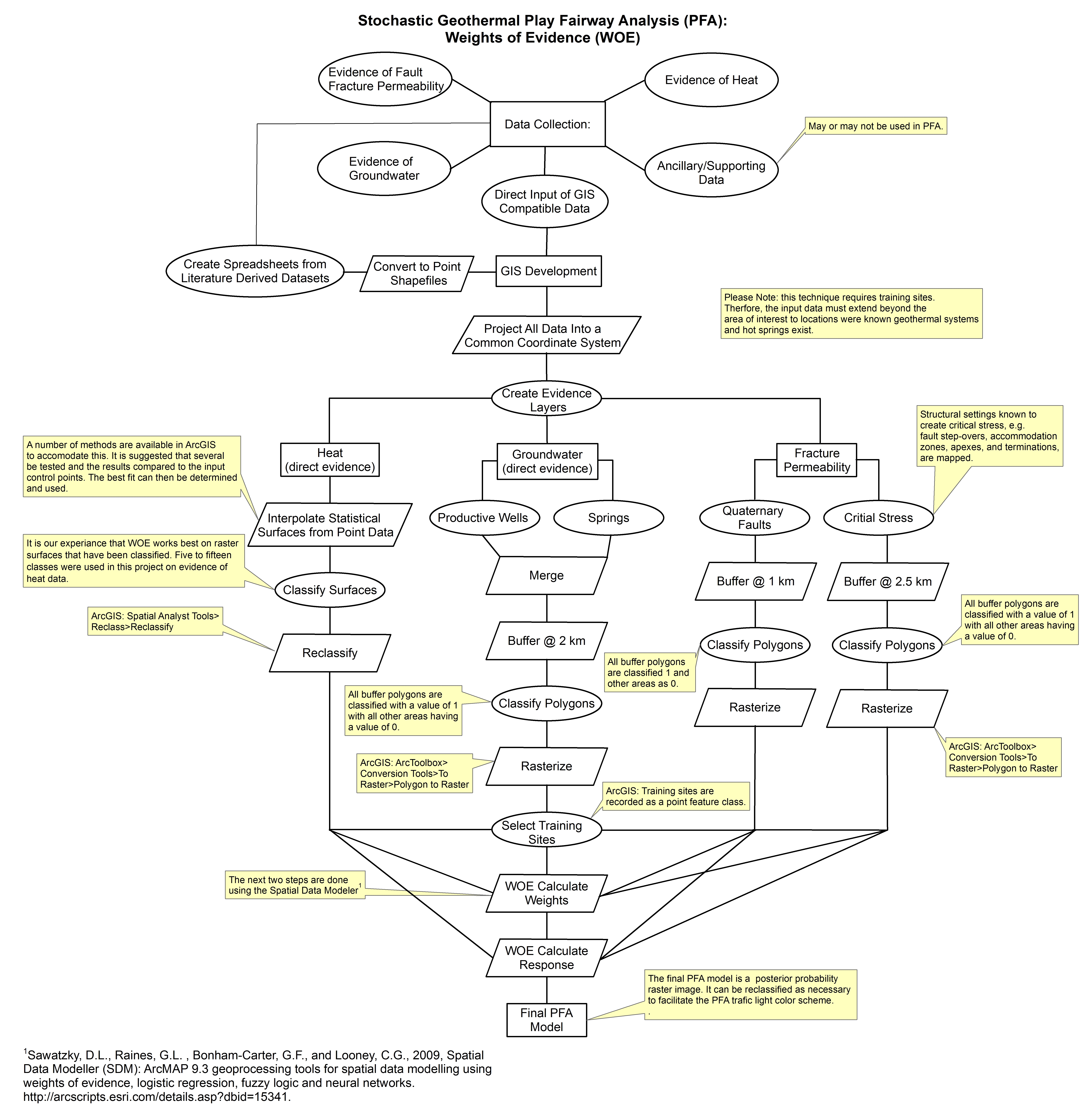
These images show the comprehensive methodology used for creation of a Play Fairway Analysis to explore the geothermal resource potential of the Tularosa Basin, New Mexico. The deterministic...
-
A cells polygon feature class was created by the U.S. Geological Survey (USGS) to illustrate the degree of exploration, type of production, and distribution of production in the United States. ...
-
A cells polygon feature class was created by the U.S. Geological Survey (USGS) to illustrate the degree of exploration, type of production, and distribution of production in the State of Kentucky....
-
A cells polygon feature class was created by the U.S. Geological Survey (USGS) to illustrate the degree of exploration, type of production, and distribution of production in the United States. ...
-
A cells polygon feature class was created by the U. S. Geological Survey (USGS) to illustrate the degree of exploration, type of production, and distribution of production in the State of...
-
A cells polygon feature class was created by the U.S. Geological Survey (USGS) to illustrate the degree of exploration, type of production, and distribution of production in the State of Ohio. ...
-
A cells polygon feature class was created by the U. S. Geological Survey (USGS) to illustrate the degree of exploration, type of production, and distribution of production in the State of Indiana....
-
A cells polygon feature class was created by the U. S. Geological Survey (USGS) to illustrate the degree of exploration, type of production, and distribution of production in the State of...
-
This shapefile contains points that describe the location of hydrocarbon exploration and production wells drilled in Afghanistan; and hyperlinks to scanned images of well logs that can be viewed...
-
The U.S. Geological Survey (USGS) has compiled a geodatabase containing mineral-related geospatial data for 19 countries of interest in the Indo-Pacific region (area of study): Bangladesh, Bhutan,...
-
This document describes a legacy collection of 2,263 scanned well logs from 621 distinct wells in the Piceance Basin of western Colorado, now made publicly available for long-term preservation....
-
This shapfile includes arcs and polygons that describe U.S. Geological Survey defined petroleum resource Assessment Units of the World. Each assessment unit is defined as a mappable volume of...
-
This shapefile includes polygons and regions that describe U.S. Geological Survey defined petroleum resource Assessment Units of northern Afghanistan. Each assessment unit is defined as a mapable...
-
The U.S. Geological Survey (USGS) has compiled a geodatabase containing mineral-related geospatial data for 10 countries of interest in Southwest Asia (area of study): Afghanistan, Cambodia, Laos,...
-
Shallow (300 ft or less) coal exploration drill-hole data from 692 wells located in Arkansas are provided in this data release. The well locations extend over nine Arkansas counties and were...
-
The U.S. Geological Survey (USGS) has compiled a geodatabase containing mineral-related geospatial data for the People's Republic of China. The data can be used in analyses of the extractive fuel...
-
This dataset comprises a collection of tabular data and graphical images supporting the U.S. Geological Survey's World Petroleum Assessment, extracted from USGS DDS 60 publication. The dataset...
