
Search Data.gov
Found 234 dataset(s) matching "Marine Emissions".
-
PEM-Tropics-A_AircraftRemoteSensing_DC8_DIAL_Data is the remotely sensed Differential Absorption Lidar (DIAL) data collected onboard the DC-8 aircraft during the Pacific Exploratory Mission (PEM)...
-
PEM-Tropics-B_AircraftRemoteSensing_DC8_DIAL_Data is the remotely sensed Differential Absorption Lidar (DIAL) data collected onboard the DC-8 aircraft during the Pacific Exploratory Mission (PEM)...
-
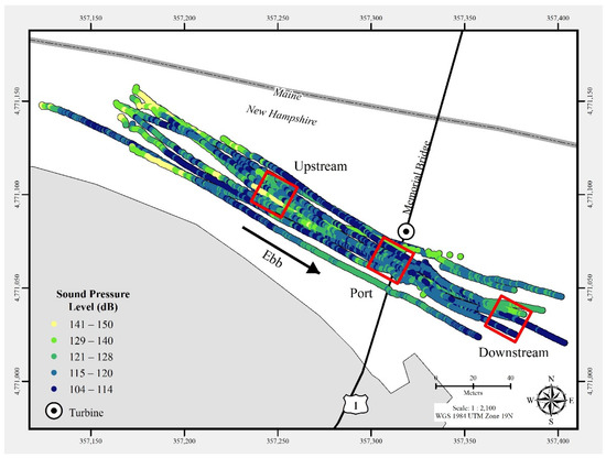
In July 2021, a commercial-off-the-shelf hydrophone was deployed in a free-drifting configuration to measure underwater acoustic emissions and characterize a 25 kW-rated tidal turbine at the...
-
The dataset is contained in a .zip file containing the two .csv files with data, and a data dictionary file. summedEmissionsSpeeds contains emissions estimates summed over several different...
-
model predicted concentrations. This dataset is associated with the following publication: Muñiz-Unamunzaga, M., R. Borge, G. Sarwar, B. Gantt, D. de la Paz, C. Cuevas, and A. Saiz-Lopez. The...
-
The Vulcan version 3.0 hourly dataset quantifies hourly emissions at a 1-km resolution for the 2010-2015 time period. Estimates are provided of hourly carbon dioxide (CO2) emissions from the...
-
The Marine Pollution Surveillance Report (MPSR) is created manually in near real time by an operational analyst when an anomaly believed to be oil is identified in satellite imagery. Reports...
