
Search Data.gov
Found 127 dataset(s) matching "Drilling testing".
-
The proposed Newberry Volcano FORGE site is in central Oregon on the northwest flank of the largest volcano in the Cascades volcanic arc. Beneath Newberry Volcano is one of the largest geothermal...
-
"This is a searchable database representing over 40 years of hydrogeologic information based on yield testing required for new and existing public water supply sources in Vermont. The VRWA final...
-
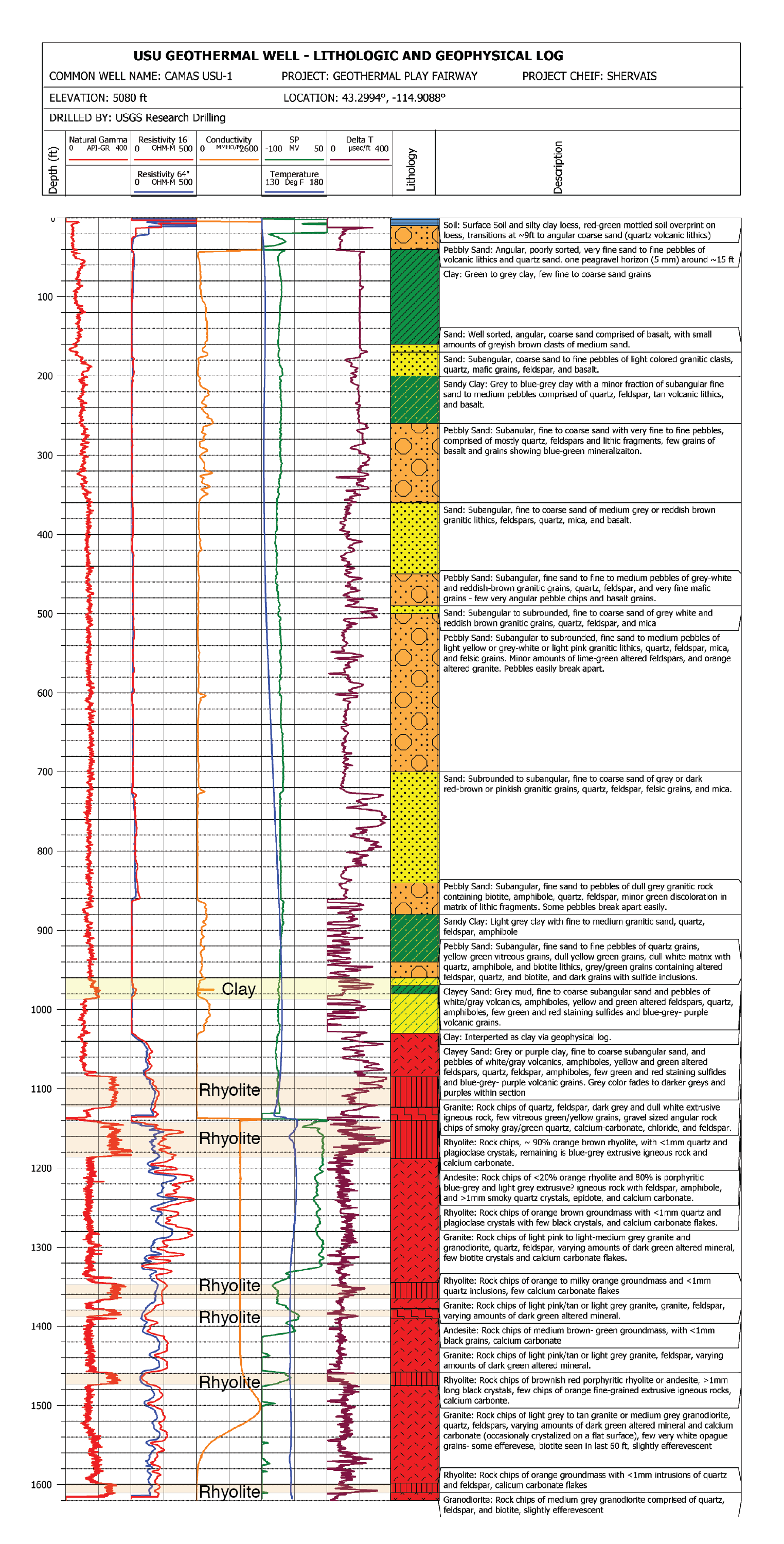
USU Camas-1 is a geothermal test well drilled in Camas Prairie, Idaho, in the Summer and Fall of 2018. The purpose of this test well was to validate Play Fairway methodologies of the Snake River...
-
The EGS Collab project is evaluating a site for Experiment 2 (hydraulic fracturing/shearing) at a depth of 1.25 km in the Sanford Underground Research Facility (SURF) on the 4100 Level. Two early...
-
This coverage contains information about the buried valleys within the Standing Rock Indian Reservation, Sioux County, North Dakota, and Corson County, South Dakota. The delineation of the buried...
-
This coverage contains information about the western limit of glaciation within the Standing Rock Indian Reservation, Sioux County, North Dakota, and Corson County, South Dakota. The digital...
-
Caldwell Ranch Exploration and Confirmation Project, Northwest Geysers, CA: 2011 Geothermal Technologies Peer Review Project Summary The Caldwell Ranch Exploration and Confirmation Project was to...
-
This coverage contains information about the surficial geology for the area within the Standing Rock Indian Reservation, Sioux County, North Dakota, and Corson County, South Dakota. Identified...
-
This report describes the geothermal resource at McGee Mountain, including: 1. Local geology 2. Thermal features 3. Known boreholes and temperature gradients 4. Geophysical surveys 5. Fluid...
-
Basal heat flow from the crystalline basement and lithospheric mantle into the sedimentary column is a required boundary condition in the petroleum systems model. The model uses two basal heat...
-
The subsurface temperature grids are results/outputs from the 3D petroleum systems model. They represent modern subsurface temperatures in degrees Fahrenheit extracted onto the stratigraphic...
-
The U.S. Department of Energy's (U.S. DOE) Frontier Observatory for Research in Geothermal Energy (FORGE) is a field laboratory that provides a unique opportunity to develop and test new...
-
This 2024 annual report for Phase 3B Year 2 at Utah FORGE provides an in-depth account of activities and advancements made at the site. Key achievements include drilling and stimulating the...
-
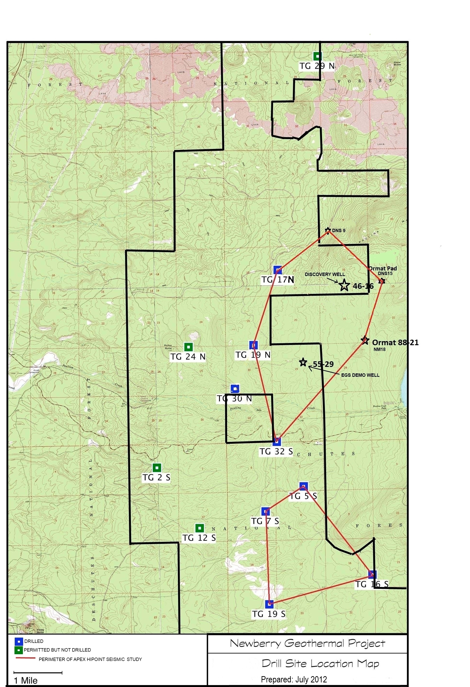
A map showing location of wells permitted, drilled and seismic test, as part of validation of innovative exploration technologies done for the Newberry Volcano project in 2012.
-
This is a link to the Utah Geological Survey's Utah FORGE Interactive Geoscience Map. The map layers include information on geology, geography, subsurface temperatures, seismicity, gravity and...
-
The EGS Collab project is evaluating a site for Experiment 2 (hydraulic fracturing/shearing) at a depth of 1.25 km in the Sanford Underground Research Facility (SURF) on the 4100 Level. Two early...
-
Kilauea, on the Island of Hawaii is one of the world’s most active volcanoes and it hosts one of the densest volcano monitoring networks. A deep well on the southwest rim of Kilauea’s caldera,...
