
Search Data.gov
Found 64 dataset(s) matching "3D seismic".
-
This dataset contains a map, showing the Utah FORGE seismic stations, and seismic velocity model data. There are 61 1-D velocity models which are in a compressed TAR file. A paper is referenced at...
-
This archive contains a report on the Mineral Mountains West fault system as part of phase 2C and the evidence for the northern terminus of this structure. Geologic field mapping, reprocessing of...
-
Gulf of Mexico Depth Grid Cells derived from BOEM's seismic grid compilation. BOEM's deepwater Gulf of Mexico bathymetry grid. Created by mosaicing over 100 3D seismic surveys. XY grid size is...
-
Recent widespread seismicity in Oklahoma is attributed to the reactivation of pre existing, critically-stressed, and seismically unstable faults due to decades of wastewater injection. However,...
-
Hypocenters of local microearthquakes and 3D P- and S-velocity models computed by simultaneous inversion of arrival times recorded by the Brady seismic network Nov 2010-Mar 2015.
-
All datasets and products specific to the Carson Sink Basin. Includes a packed ArcMap (.mpk), individually zipped shapefiles, and a file geodatabase for the Carson Sink area; a GeoSoft Oasis...
-
This is data from and a final report on the development of a 3D velocity model for the larger FORGE area and on the seismic resolution in the stimulated fracture volume at the bottom of well...
-
A three-dimensional (3D) geologic framework of the conterminous United States is presented here as part of the U.S. Geological Survey National Crustal Model for Seismic Hazard Studies. The...
-
2011 Peer Review of the 'Conducting a 3D Converted Shear Wave' Project to reduce exploration risk at Wister, CA.
-
2010 Peer Review of the 'Conducting a 3D Converted Shear Wave' Project to reduce exploration risk at Wister, CA. The presentation includes a timeline, budget, barriers, and partners. The objective...
-
This is a 3D geological movie of the Utah FORGE area created with Leapfrog Geothermal 3D modelling software. The movie shows the Utah FORGE site, wells, seismic and lithologic cross-sections, and...
-
Paragon Geophysical contracted Urban Seismic Specialists to conduct A Ground Motion Study, on their Forge 3D project located near in Milford Utah .The test was conducted to measure the effects of...
-
Document describing the methodology used to determine the accelerometers' three-component orientations at the first EGS Collab testbed using Continuous Active-Source Seismic Monitoring (CASSM)...
-
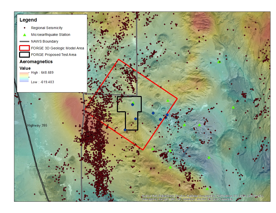
A map with the Coso West Flank FORGE test area outlined, along with regional seismicity, the aeromagnetic data set and the area currently being utilized for the creation of the 3D model.
-
Newly reprocessed Naval Air Station Fallon (1994) seismic lines: pre-stack depth migrations, with interpretations to support the Fallon FORGE (Phase 2B) 3D Geologic model. Data along seven...
-
The Mohorovicic discontinuity or 'Moho' maps the boundary between the earth's crust and mantle and is defined by an abrupt change in seismic velocity due to changes in the density of rocks between...
