
Search Data.gov
Found 553 dataset(s) matching "pumping data".
-
The sampling of the riverine-to-marine transect (Penobscot River, Penobscot Bay, and the Gulf of Maine) took place in 2008. Water samples were collected and filtered in the field using 0.45...
-
This dataset consists of discrete profile and surface underway measurements of carbonate chemistry and others hydrographic and chemical parameters, collected during R/V Neeskay and R/V Osprey...
-
A three-dimensional groundwater flow model (MODFLOW-2005) of the Mississippi embayment, South-Central United States, was developed as part of a national project initiated by the U.S. Geological...
-
There is a growing interest in incorporating higher-resolution groundwater modeling within the framework of large-scale land surface models (LSMs), including new processes such as...
-
Samples were collected at or near baseflow conditions. Water pH and specific conductance were measured in the field, with specific conductance also measured in the laboratory and calculated based...
-
A three-dimensional MODFLOW-NWT model was constructed to better understand the effects of drought stress on the Cedar River alluvial aquifer, the principal source of municipal water for the City...
-
This data release provides suspended-sediment (concentration and load) and water temperature data for two locations along the Suiattle River (USGS 12187900 and 12188380) and a tributary, Downey...
-
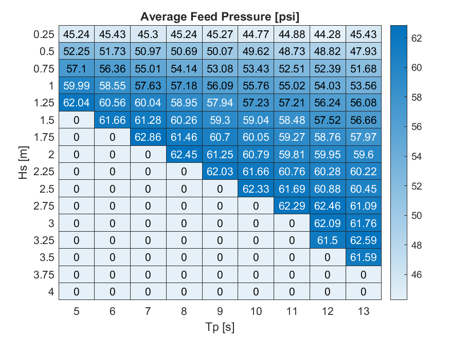
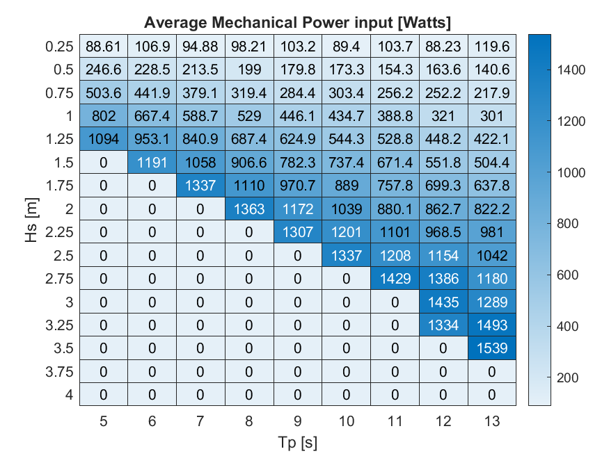
This project focused on developing an automated workflow to evaluate and optimize the iProTech Pitching Inertial Pump (PIP) wave energy converter (WEC) using open-source Python packages and the...
-
Included here are two fiber optics monitoring reports on Utah FORGE well 16B(78)-32 from Neubrex Energy Services. These reports review the fiber optics monitoring during both the cementing and...
-
A three-dimension groundwater-flow model (MODFLOW-2005) was developed to improve understanding of groundwater flow and pumping effects near the Long Canyon Mine in Goshute Valley, northeastern...
-
This dataset contains laboratory experimental data of blue mussels (Mytilus edulis) exposed to three different levels of carbon dioxide (low, mid, and high) from 4 hours post fertilization to day...
-
This data release contains borehole video and aquifer-test data for the Burnpit well (U.S. Geological Survey [USGS] National Water Information System identification 435240103265301), Mount...
-
A new groundwater flow model for western Chippewa County, Wisconsin has been developed by the Wisconsin Geological and Natural History Survey (WGNHS) and the U.S. Geological Survey (USGS). An...
-
These data are high-resolution bathymetry (riverbed elevation) in compressed LAS (*.laz) format, generated from the July 17–19, 2023, hydrographic survey of Bubbly Creek and various sidings,...
-
The Little Colorado River alluvial aquifer near Leupp, Arizona was investigated as a possible source of irrigation water for the Leupp and Birdsprings Chapters of the Navajo Nation. The physical,...
-
<div style='text-align:Left;'><p><span style='font-family:"Avenir Next W01", "Avenir Next W00", "Avenir Next", Avenir, "Helvetica Neue", sans-serif;...
-
This dataset includes the 1990, 1991 and 1992 Phytoplankton and Geochemical data from the Columbia River Turbidity Maximum (CRETM) / Land Margin Ecosystem Research Program (LMER). There are 2...
-
These CTD data were obtained during the NSF-sponsored RISE project during July 2004, June 2005, and May-June 2006, on the continental shelf off Oregon and Washington, USA, in the Northeast Pacific...
