
Search Data.gov
Found 1022 dataset(s) matching "3D Models".
-
The U.S. Geological Survey (USGS) National Uncrewed Systems Office (NUSO) supported the USGS National Cooperative Geologic Mapping Program’s Geoheritage Sites of the Nation Project in July of 2024...
-
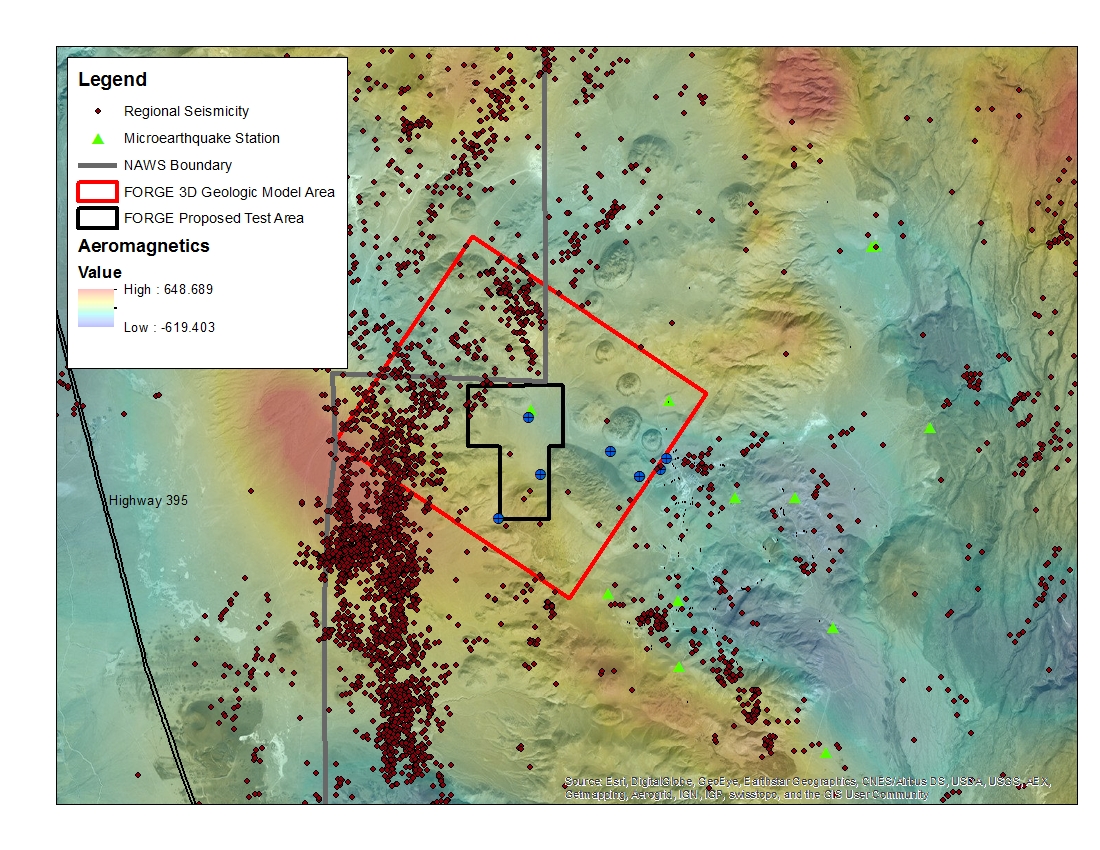
A map with the Coso West Flank FORGE test area outlined, along with regional seismicity, the aeromagnetic data set and the area currently being utilized for the creation of the 3D model.
-
Electrical resistivity results from four regional airborne electromagnetic (AEM) surveys (Burton et al. 2024, Hoogenboom et al. 2023, Minsley et al. 2021, Burton et al. 2021) over the Mississippi...
-
Electrical resistivity results from two regional airborne electromagnetic (AEM) surveys (Minsley et al. 2021, and Burton et al. 2021) over the Mississippi Alluvial Plain (MAP) were combined by the...
-
This digital dataset contains the percentage of coarse-grained deposits in wells in 15 meter increments and the percentage of coarse-grained deposits in texture model lattice points interpolated...
-
This digital dataset contains the categories used to classify the basin-fill deposits in the Central Valley as either coarse-grained or fine-grained deposits. This classification was used to...
-
New gravity and magnetic compilations and elevation-bathymetry models have been compiled for the Lake Superior region. These data provide continuous sets of observations for geologic...
-
Cleft palate (CP) is a common birth defect, occurring in an estimated 1 in 1000 births worldwide. The secondary palate is formed by paired palatal shelves that grow toward each other, appose,...
-
This data archive includes the relocated microseismic event catalog and 3D velocity model from DAS acquisition conducted during the 16A stimulations that took place between April 3rd and April...
-
Note: please go to https://data.sfgov.org/d/ynuv-fyni to access the same data in additional open formats. These footprint extents are collapsed from an earlier 3D building model provided by...
-
As part of the periodic update of the geothermal energy assessments for the USA (e.g., last update by Williams and others, 2008), a new three-dimensional temperature map has been constructed for...
-
Newly reprocessed Naval Air Station Fallon (1994) seismic lines: pre-stack depth migrations, with interpretations to support the Fallon FORGE (Phase 2B) 3D Geologic model. Data along seven...
-
This data includes the locations of the MT data collected in and around the Coso Geothermal field that covered the West Flank area. These are the data that the 3D MT models were created from that...
-
These footprint extents are collapsed from an earlier 3D building model provided by Pictometry of 2010, and have been refined from a version of building masses publicly available on the open data...
-
Multibeam and sidescan sonar were collected for a total of 15 sites in the North Arm, Maxwell Bay, and St. Albans Bay of Lake Minnetonka, Minnesota, to determine whether hydroacoustics could be...
-
This dataset includes magnetotelluric transfer functions in the form of EDI files for 16 stations collected by the USGS and 40 stations collected by Quantec Geoscience for Lawerence Berkeley...
-
This package contains principal facts for new gravity data collected September - November 2017 in support of the Fallon FORGE project. Also included are rock core density and magnetic...
-
The occurrence and impact of the February 2023 earthquake doublet in Türkiye, where an Mw 7.8 event was followed roughly 9 hours later by an Mw 7.5 event on an adjacent fault, begs the question:...
-
This dataset consists of 176 wideband magnetotelluric (MT) stations collected from 2015-2019 across parts of Minnesota, Wisconsin and the Upper Peninsula of Michigan. The U.S. Geological Survey...
-
This dataset consists of 176 wideband magnetotelluric (MT) stations collected from 2015-2019 across parts of Minnesota, Wisconsin and the Upper Peninsula of Michigan. The U.S. Geological Survey...
