
Search Data.gov
Found 486 dataset(s) matching "permeability".
-
This U.S. Geological Survey (USGS) metadata record consists of 17 different spatial layers in GeoTIFF format for the Hawaii. They are: 1) average water capacity (awc.zip), 2) percent sand...
-
This paper documents our effort to use a fully coupled hydro-geomechanical numerical test bed to study using low hydraulic pressure to stimulate geothermal reservoirs with existing fracture...
-
This study determines the exfiltration rates in six tree boxes and analyzes their performance over time. The study site is in Louisville, KY, where we monitored the performance of six tree boxes...
-
This dataset provides information on the viability of organotypic approaches in evaluating extracellular vesicles (EVs) to investigate exposure-induced biomarkers and underlying mechanisms. Data...
-
Hydrologic landscape regions (HLRs) in the United States were delineated by using geographic information system (GIS) tools and statistical methods including principal components and cluster...
-
This geospatial dataset includes a one-point feature-class shapefile, one-polygon feature-class shapefile, and associated FGDC-compliant metadata to define 193 streamflow and 299 basin ...
-
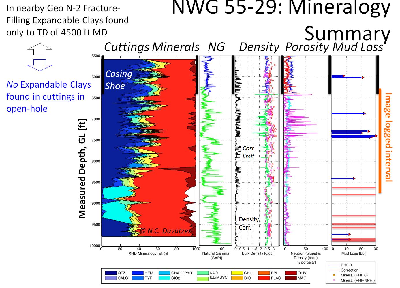
Caldwell Ranch Exploration and Confirmation Project, Northwest Geysers, CA: 2011 Geothermal Technologies Peer Review Project Summary The Caldwell Ranch Exploration and Confirmation Project was to...
-
A water vapour permeable laminate (16), especially for use as underroofing or underslating for roofs. The laminate comprises an outer layer (18) that is formed by a perforated first film or foil,...
-
Three-dimensional numerical models were used to determine the permeable pathways between the HANDLEY underground nuclear test and downgradient boreholes ER-20-12 and PM-3, Pahute Mesa, southern...
-
The utility of passive seismic emission tomography for mapping geothermal permeability has been tested at San Emidio in Nevada. The San Emidio study area overlaps a geothermal field in production...
-
Fibers from the card cylinder (3) are deposited in an airflow through a chute (2) on an air-permeable conveyor (11) to form a non-woven. The position of the chute side (4) together with the roller...
-
This U.S. Geological Survey (USGS) metadata release consists of 17 different spatial layers in GeoTIFF format. They are: 1) average water capacity (AWC.zip), 2) percent sand (Sand.zip), 3) percent...
-
The hydrogeology of the valley-fill aquifer system along a 32-mile reach of the Susquehanna River valley and adjacent areas was evaluated in eastern Broome and southeastern Chenango Counties,...
-
The Area 10 mule deer population is one of the largest deer herds in the state, accounting for roughly 20 percent of the statewide mule deer population. The Area 10 herd is comprised of several...
-
This dataset consists of a workspace (folder) containing 41 gridded datasets and a personal geodatabase. The gridded datasets consist of 28 precipitation-frequency grids, a mean annual...
-
The Utah FORGE 2025 v1 DFN (fracture model) includes 131 discrete planar fractures which were identified using combined site data sets to capture flow pathways between wells 16A(78)-32 and...
-
This dataset represents lineaments in the Powder River Basin as identified in the following publication: Slack, P. B., 1981, Paleotectonics and hydrocarbon accumulation, Powder River basin,...
-
This dataset represents the soil characteristic within individual, local NHDPlusV2 catchments and upstream, contributing watersheds based on the STATSGO landscape rasters. Attributes of the...
-
The invention relates to a cooling device ( 1 ) for cooling an item to be cooled, especially for use in the examination, handling and processing of cryogenic samples. The device includes a cooling...
