
Search Data.gov
Found 419 dataset(s) matching "tidal currents".
-
Time-series data of water depth, velocity, turbidity, and temperature were acquired between 5 October 2015 and 21 March 2017 within the Monterey Canyon off of Monterey, CA, USA. In order to...
-
The U.S. Army Engineer Research and Development Center, in collaboration with the U.S. Geological Survey Wetland and Aquatic Research Center, collected hydrographic data to investigate sediment...
-
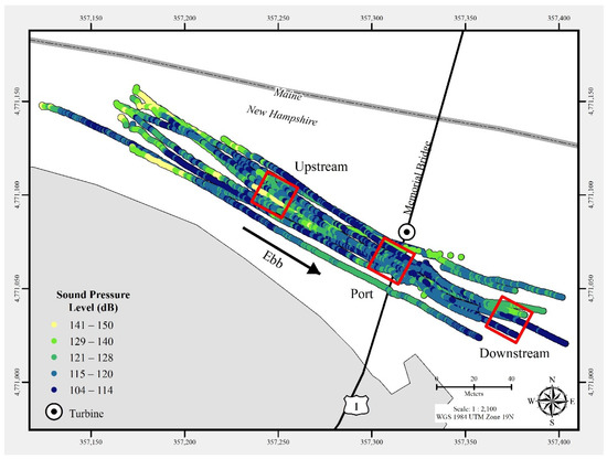
In July 2021, a commercial-off-the-shelf hydrophone was deployed in a free-drifting configuration to measure underwater acoustic emissions and characterize a 25 kW-rated tidal turbine at the...
-
This submission includes the Component Content Model for Verdant Power TriFrame and the System Content Model for Verdant Power TriFrame + 3 Gen5 KHPS Turbines. The TriFrame is the foundation...
-
An upward-looking acoustic Doppler velocity meter (ADVM, SonTek SW, 3.0 MHz) located in a tidal channel of the Nisqually River Delta at site D1 (N 47d 05’ 37”/W 122d 43’ 17”) measured water level...
-
An upward-looking acoustic Doppler velocity meter (ADVM, SonTek SW, 3.0 MHz) located in a tidal channel of the Nisqually River Delta at site D3 (N 47d 05’ 36.5”/W 122d 42’ 42.9”) measured water...
-
Tidal cycle water velocities were measured at transects in the Bushy Park Reservoir using Teledyne Rio Grande 1200 kHz acoustic Doppler current profilers (ADCP). Five transects were measured on...
-
An upward-looking acoustic Doppler velocity meter (ADVM, SonTek SW, 3.0 MHz) located in a tidal channel of the Nisqually River Delta at site D2 (N 47d 05’ 37.2”/W 122d 42’ 56.4”) measured water...
-
An upward-looking acoustic Doppler velocity meter (ADVM, SonTek SW, 3.0 MHz) located in a tidal channel of the Nisqually River Delta at site D4 (N 47d 05’ 37”/W 122d 42’ 18.7”) measured water...
-
Whales Tail Marsh, a restored salt pond in South San Francisco Bay, California, is experiencing rapid shoreline erosion. Determining whether the eroded sediment is exported to the ocean or...
-
This collection includes data collected from multiple platforms in the coastal waters of California over many years, as part of the California Cooperative Fisheries Investigation (CalCOFI)...
-
The ADV measurements contained in this submission were taken on the floating turbine deployment platform (TDP) located at the Memorial Bridge in Portsmouth, NH. The measurements were conducted...
-
Hydrodynamic and sediment transport time-series data, including water depth, velocity, turbidity, suspended particle size, conductivity, and temperature, were collected by the U.S. Geological...
-
This data type contains data from field sampling of marine organisms in intertidal or subtidal habitats. The data were collected to provide information about species abundance and distribution....
-
<DIV STYLE="text-align:Left;"><DIV><DIV><P STYLE="margin:0 0 11 0;"><SPAN>The 2018 Marine Protected Area Monitoring Action Plan identified three bioregions for long-term marine protected area...
-
Files contain hydrodynamic and sediment transport data for the location and deployment indicated. Time-series data of water depth, velocity, turbidity, and temperature were collected in San Pablo...
