
Search Data.gov
Found 1168 dataset(s) matching "well test".
-
Tabular and raster data containing spatial capture recapture records for male and female black bears (Ursus americanus) in Glacier National Park and surrounding landscape collected from June -...
-
The dataset includes personally identifying data from questionnaires (demographic, socioeconomic, behavioral and health data) as well as results of laboratory tests of serum samples for biomarkers...
-
Pneumatic and traditional (physical) slug tests are presented for monitoring wells in Hinkley Valley, California, 2015-2017. Data were collected in support of a U.S. Geological Survey study on...
-
This data release provides comprehensive results of monotonic trend assessment for long-term U.S. Geological Survey (USGS) streamgages in or proximal to the watersheds of Mobile and Perdido Bays,...
-
Recovered fentanyl amounts from all materials included in the fentanyl decontamination tests (multiple different decontaminants). Datasets include recoveries from test coupons (contaminated and...
-
This is an analysis of the pressure falloff in stage 1 fracture stimulation of FORGE well 16A(78)-32. The objective of this research is to understand the information content of the well...
-
This dataset contains numerical simulation meshes and modeling results from extended circulation and pulse interference tests conducted between Utah FORGE wells 16A(78)-32 and 16B(78)-32. The...
-
<p>Images are used frequently in plant phenotyping to capture measurements. This chapter offers a repeatable method for capturing two-dimensional measurements of plant parts in field or laboratory...
-
This preliminary data archive includes the relocated microseismic event catalog, 1D velocity model, and methods report from DAS acquisition conducted during the Well 16A and 16B circulation test...
-
Green and others (2021) developed a gradient boosted regression tree model to predict the mean groundwater age, or travel time, for shallow wells across a portion of the Great Lakes basin in the...
-
This data release presents pumping rate data, water-level drawdown and recovery data, and atmospheric pressure data collected during 48 pumping tests conducted in 2015 and 2016 for a hydraulic...
-
This public data release contains two ascii grids comprising predicted nitrate concentrations (as NO3-N, mg/L) at two depth zones associated with private and public drinking water supply wells,...
-
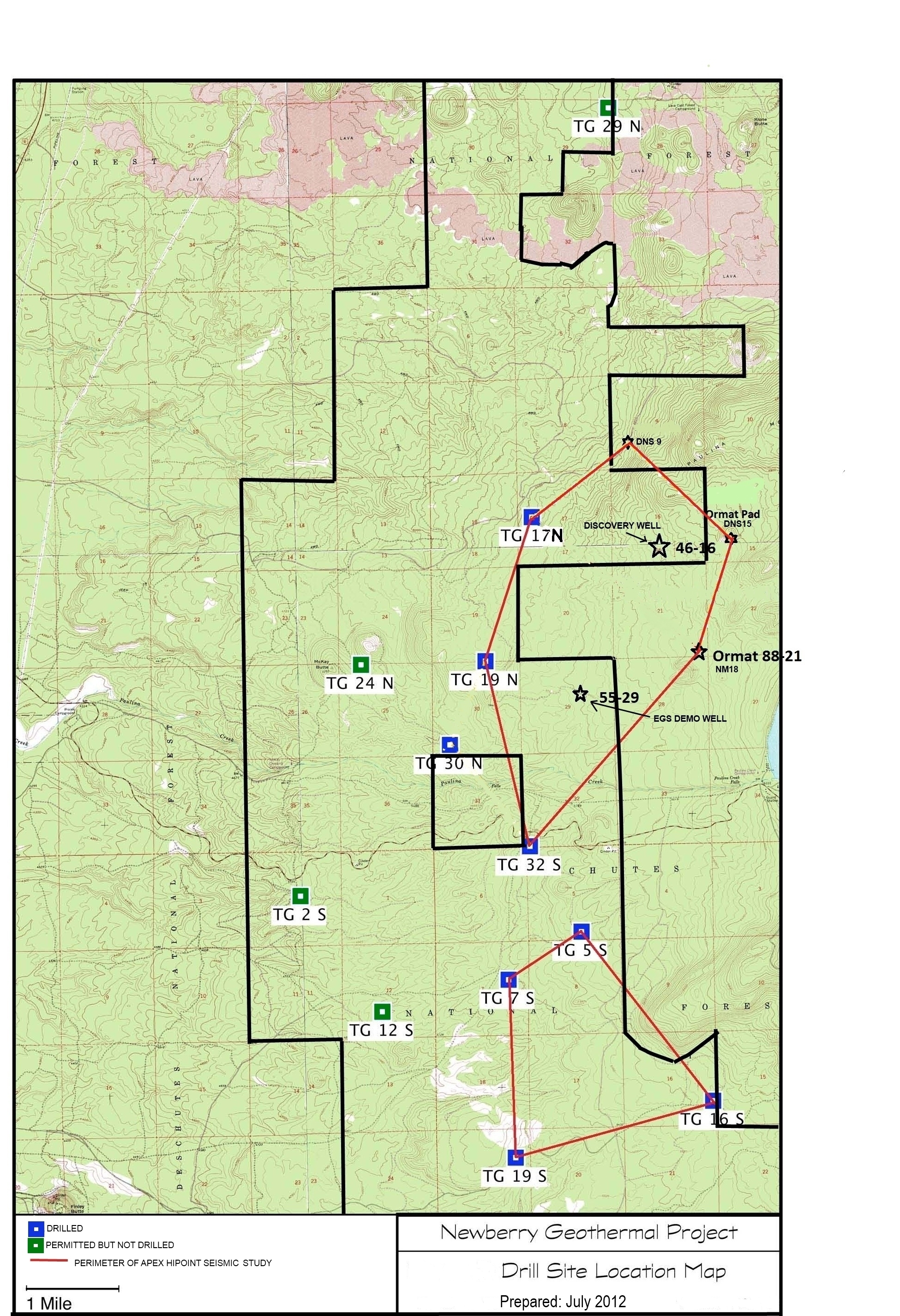
A map showing location of wells permitted, drilled and seismic test, as part of validation of innovative exploration technologies done for the Newberry Volcano project in 2012.
-
The goal of this study was to identify and evaluate case management and supervision strategies most effective in achieving successful parole outcomes. As part of an evaluation of 3 new...
-
The U.S. Geological Survey (USGS), in cooperation with the Lewis and Clark Natural Resources District (NRD), Lower Elkhorn NRD, Lower Loup NRD, Lower Platte North NRD, Lower Niobrara NRD, Middle...
-
A three-dimensional, groundwater flow model was developed with the numerical code MODFLOW-NWT to represent changes in groundwater pumping and aquifer recharge in the Northern Atlantic Coastal...
-
This report summarizes the community discussions at the 2024 NASA Surface Biology and Geology (SBG) Technical Interchange Meeting (TIM) from May 29 to 31, 2024, in Washington, D.C., US. The report...
-
Freshwater salinization is an emerging water quality issue for non-tidal streams and rivers in the Chesapeake Bay watershed (CBW), USA region. A model was developed to predict specific conductance...
-
Report on a formation thermal conductivity test that was performed on the geothermal test bore at Ulbrich Heights at 38 Louis Circle Lane in Wallingford, Connecticut. Data are applicable only...
-
These data are part of NACJD's Fast Track Release and are distributed as they there received from the data depositor. The files have been zipped by NACJD for release, but not checked or processed...
