
Search Data.gov
Found 2573 dataset(s) matching "ocean test".
-
The USGS, in cooperation with NOAA, is producing detailed maps of the seafloor off southern New England. The current phase of this cooperative research program is directed toward analyzing how...
-
NARSTO_EPA_SS_PITTSBURGH_PM_COMPOSITION_DATA is the North American Research Strategy for Tropospheric Ozone (NARSTO) Environmental Protection Agency (EPA) Supersite (SS) Pittsburgh Particulate...
-
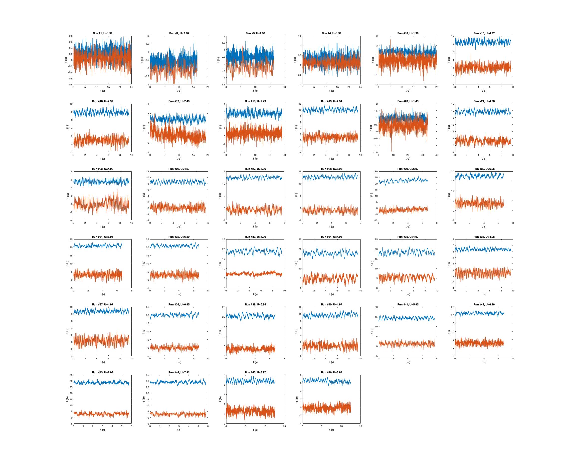
This document presents results from tests to demonstrate underwater mapping capabilities of an underwater vehicle in conditions typically found in marine renewable energy arrays. These tests were...
-
The USGS, in cooperation with NOAA, is producing detailed maps of the seafloor off southern New England. The current phase of this cooperative research program is directed toward analyzing how...
-
Across all five New England reserves, this project team will deploy a novel sensor package to measure greenhouse gases and develop a salt marsh greenhouse gas monitoring protocol for reserves and...
-
Salinity dynamics in the Delaware Bay estuary are a critical water quality concern as elevated salinity can damage infrastructure and threaten drinking water supplies. Current state-of-the-art...
-
Multiple subaerial landslides adjacent to Prince William Sound, Alaska (for example, Dai and others, 2020; Higman and others, 2023; Schaefer and others, 2024) pose a threat to the public because...
-
Subaerial and submarine landslides adjacent to, and within, Glacier Bay, Glacier Bay National Park and Preserve (GBNPP), Alaska pose a threat to the public because of their potential to generate...
-
This data release contains model output from simulations presented in the associated Open-File Report (Barnhart and others, 2021). In this report, we present model results from four simulations...
-
This TEAMER RFTS 1 (Request for Technical Support) project supported the flume tank testing of a long range, high endurance unmanned underwater vehicle (UUV) to monitor maritime space. Today,...
-
Contains the Reference Model 6 (RM6) spreadsheets with the cost breakdown structure (CBS) for the levelized cost of energy (LCOE) calculations for a single RM6 device and multiple unit arrays....
-
Contains the Reference Model 6 (RM6) full scale geometry files of the Oscillating Water Column, developed by the Reference Model Project (RMP). These full scale geometry files are saved as...
-
<p><br></p> <p>[NOTE - 11/24/2021: this dataset supersedes an earlier version <a href="https://doi.org/10.15482/USDA.ADC/1518654" target="_blank">https://doi.org/10.15482/USDA.ADC/1518654</a>...
-
In order to test hypotheses about groundwater flow under and into Chesapeake Bay, geophysical surveys were conducted by U.S. Geological Survey (USGS) scientists on Chesapeake Bay and the Potomac...
-
In order to test hypotheses about groundwater flow under and into Chesapeake Bay, geophysical surveys were conducted by U.S. Geological Survey (USGS) scientists on Chesapeake Bay and the Potomac...
-
In order to test hypotheses about groundwater flow under and into Chesapeake Bay, geophysical surveys were conducted by U.S. Geological Survey (USGS) scientists on Chesapeake Bay and the Potomac...
-
Stable oxygen and carbon isotope composition (δ18O and δ13C) and magnesium-to-calcium (Mg/Ca) ratios were measured in the tests of planktic foraminiferal species, Globigerinoides ruber (white...
-
In order to test hypotheses about groundwater flow under and into Chesapeake Bay, geophysical surveys were conducted by U.S. Geological Survey (USGS) scientists on Chesapeake Bay and the Potomac...
-
In order to test hypotheses about groundwater flow under and into Chesapeake Bay, geophysical surveys were conducted by U.S. Geological Survey (USGS) scientists on Chesapeake Bay and the Potomac...
