
Search Data.gov
Found 9918 dataset(s) matching "universities".
-
Background It is widely considered that improved diagnostics in suspected acute coronary syndrome (ACS) are needed. To help clarify the current situation and the improvement potential,...
-
A partnership with the University of Louisiana and U.S. Department of Energy's National Renewable Energy Laboratory (NREL) to collect solar data to support future solar power generation in the...
-
Campuses which comprise the State University of New York (SUNY) System. Highlights information on Undergraduate and Graduate enrollment as well as some program area offerings.
-
Historic Highway Performance Monitoring System universe data for the year 2007
-
<p>PAHAW Study for Greenhouse gas Reduction through Agricultural Carbon Enhancement network in University Park, Pennsylvania</p> <div><br>Resources in this dataset:</div><br><ul><li><p>Resource...
-
This page provides information about award recipients, project abstracts, and summaries of competitions under the Master's Degree Programs at Historically Black Colleges and Universities Program.
-
The Digital Geomorphologic-GIS Map of Sagamore Hill National Historic Site and Vicinity, New York is composed of GIS data layers and GIS tables, and is available in the following GRI-supported GIS...
-
Measurements of pCO2 taken by the University of Southern Mississippi in the Gulf of Mexico near the Louisiana coast in 2005 and 2006
-
Measurements from the Atlantic Ocean made by the University of Maryland between New England, Bermuda, and Brazil in 2003.
-
Bedrock Geology of Champaign County, Illinois, map layers (shapefiles). Layers included: 1) Champaign County bedrock units. 2) Champaign County bedrock surface contours. Contour interval of 25...
-
Measurements made by the Johns Hopkins University Applied Physics Laboratory (JHUAPL) near the island of Kauai in 1993.
-
Measurements made in Lake Superior by researchers at the University of Rhode Island.
-
Location: Oklahoma City, Oklahoma Home Visiting Program Selected: SafeCare Home Visiting Target Population: Families with at least one child age 5 years or younger and at least one of the...
-
A Multi University Research Initiative was funded to study the biological response to the dynamic, polarized light field in distinct water types. During June 2010, a campaign was undertaken in the...
-
The Digital Geologic-GIS Map of Tau, American Samoa is composed of GIS data layers and GIS tables, and is available in the following GRI-supported GIS data formats: 1.) a 10.1 file geodatabase...
-
**THIS NEWER 2016 DIGITAL MAP REPLACES THE OLDER 2014 VERSION OF THE GRI FIIS Pre-Hurricane Sandy Map. The Unpublished Digital Pre-Hurricane Sandy Geomorphological Map of Fire Island National...
-
The Unpublished Digital Geomorphic Map of the Shackleford Banks, North Carolina is composed of GIS data layers and GIS tables in a 10.1 file geodatabase (shkb_geology.gdb), a 10.1 ArcMap (.MXD)...
-
Historic Highway Performance Monitoring System universe data for the year 1994
-
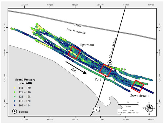
In July 2021, a commercial-off-the-shelf hydrophone was deployed in a free-drifting configuration to measure underwater acoustic emissions and characterize a 25 kW-rated tidal turbine at the...
-
The Unpublished Digital Bedrock Geologic Map of Obed Wild and Scenic River and Vicinity, Tennessee is composed of GIS data layers and GIS tables in a 10.1 file geodatabase (obed_geology.gdb), a...
