
Search Data.gov
Found 965 dataset(s) matching "well planning".
-
This document is a supplement to the President's FY2022 Budget Request to Congress. Following Congressional mandate, the Supplement incorporates budgetary and programmatic information for member...
-
This is a MD iMAP hosted service. Find more information at http://imap.maryland.gov. This is a map service of archived political districts in the state of Maryland. 2002 districts are depicted....
-
This is a MD iMAP hosted service. Find more information at http://imap.maryland.gov. This is a map service of archived political districts in the state of Maryland. 2002 districts are depicted....
-
The Forest Service's Natural Resource Manager (NRM) Forest Activity Tracking System (FACTS) is the agency standard for managing information about activities related to fire/fuels, silviculture,...
-
The Toxics Release Inventory (TRI) is a dataset compiled by the U.S. Environmental Protection Agency (EPA). It contains information on the release and waste management for over 800 toxic...
-
Inventory survey on Kirwin National Wildlife Refuge to develop a current baseline vegetation map. The completed vegetation map will aid in facilitating evaluation of management alternatives, aid...
-
The Forest Service's Natural Resource Manager (NRM) Forest Activity Tracking System (FACTS) is the agency standard for managing information aboutactivities related to fire/fuels, silviculture, and...
-
<b>Note:</b> <b>This is a large dataset. </b>To download, go to <a href='https://enterprisecontentnew-usfs.hub.arcgis.com/datasets/hazardous-fuel-treatment-reduction-polygon-feature-layer'...
-
The Forest Service's Natural Resource Manager (NRM) Forest Activity Tracking System (FACTS) is the agency standard for managing information aboutactivities related to fire/fuels, silviculture, and...
-
The Forest Service's Natural Resource Manager (NRM) Forest Activity Tracking System (FACTS) is the agency standard for managing information aboutactivities related to fire/fuels, silviculture, and...
-
These data include groundwater-level data from 59 wells measured from July to August 2017. Measured groundwater data are also available from the USGS National Water Information System (U.S....
-
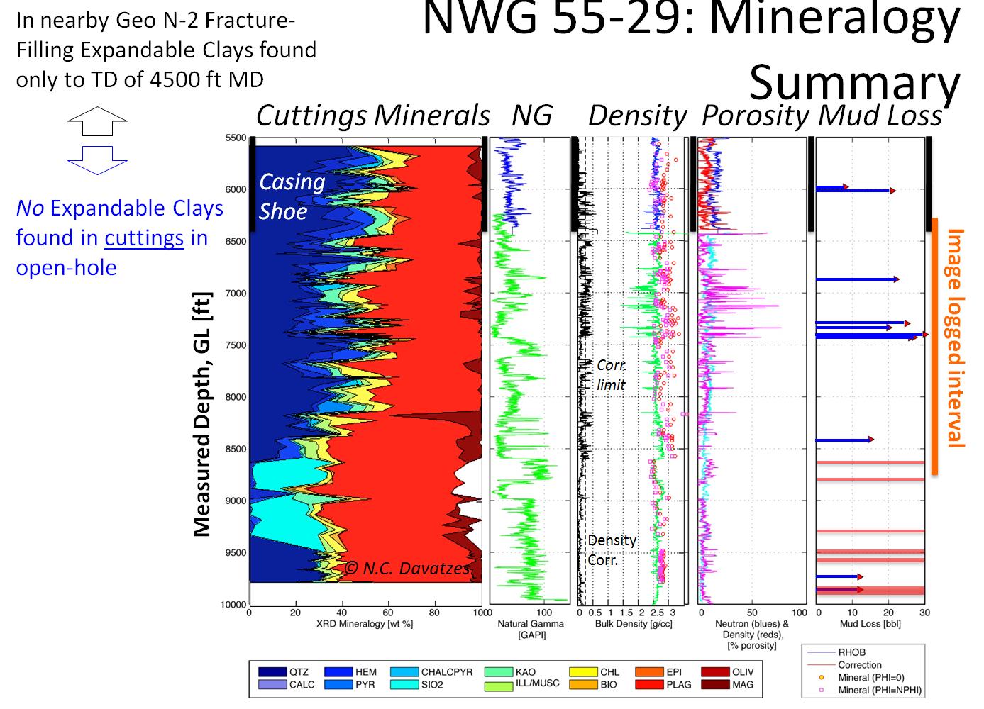
This is a compilation of logs and data from Well 82-33 in the Roosevelt Hot Springs area in Utah. This well is also in the Utah FORGE study area. The file is in a compressed .zip format and there...
-
A panel with representatives from the Children’s Bureau, as well as Delaware, Oklahoma, and Utah states, discuss lessons learned and provide recommendations for improving data quality...
-
<div><font size='4'><font color='#000000' style='background-color: rgb(255, 255, 255);'>This is the main map application for CAL FIRE's 2017 Strategic Fire Plan Accomplishments. This app is...
-
A water-supply plan is being developed for Wake County, North Carolina, in accordance with the 50-year planning window used by the North Carolina Division of Water Resources for residents in...
-
The Newberry Volcano EGS Demonstration in central Oregon, a 5 year project begun in 2010, tests recent technological advances designed to reduce the cost of power generated by EGS in a hot, dry...
-
The Newberry Volcano EGS Demonstration in central Oregon, a 3 year project started in 2010, tests recent technological advances designed to reduce the cost of power generated by EGS in a hot, dry...
-
<div style='font-family:"Segoe UI", "Segoe UI Web", Arial, Verdana, sans-serif; margin:0px; padding:0px; clear:both; color:rgb(0, 0, 0); font-size:12px;'><p...
