
Search Data.gov
Found 1310 dataset(s) matching "West Region".
-
Due to continued coastal population growth and increased threats of erosion, current data on trends and rates of shoreline movement are required to inform shoreline and floodplain management. The...
-
Due to continued coastal population growth and increased threats of erosion, current data on trends and rates of shoreline movement are required to inform shoreline and floodplain management. The...
-
Due to continued coastal population growth and increased threats of erosion, current data on trends and rates of shoreline movement are required to inform shoreline and floodplain management. The...
-
Due to continued coastal population growth and increased threats of erosion, current data on trends and rates of shoreline movement are required to inform shoreline and floodplain management. The...
-
Due to continued coastal population growth and increased threats of erosion, current data on trends and rates of shoreline movement are required to inform shoreline and floodplain management. The...
-
Due to continued coastal population growth and increased threats of erosion, current data on trends and rates of shoreline movement are required to inform shoreline and floodplain management. The...
-
Due to continued coastal population growth and increased threats of erosion, current data on trends and rates of shoreline movement are required to inform shoreline and floodplain management. The...
-
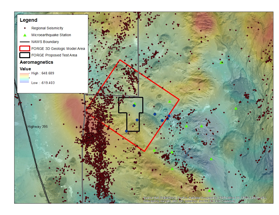
A map with the Coso West Flank FORGE test area outlined, along with regional seismicity, the aeromagnetic data set and the area currently being utilized for the creation of the 3D model.
-
The Mid-Columbia mule deer herd inhabits a highly variable landscape, featuring annual precipitation ranging from 112 inches (in; 285 cm) near Red Hill in the western part of this herd range to 14...
-
The Mid-Columbia mule deer herd inhabits a highly variable landscape, featuring annual precipitation ranging from 112 inches (in; 285 cm) near Red Hill in the western part of this herd range to 14...
-
The Mid-Columbia mule deer herd inhabits a highly variable landscape, featuring annual precipitation ranging from 112 inches (in; 285 cm) near Red Hill in the western part of this herd range to 14...
-
This data release provides pinyon jay (Gymnorhinus cyanocephalus) counts and local-scale vegetation data associated with summertime point count surveys conducted throughout the InterMountain West...
-
The United States Geological Survey (USGS) is conducting a study on the effects of climate change on ocean acidification within the Gulf of Mexico; dealing specifically with the effect of ocean...
-
The United States Geological Survey (USGS) is conducting a study on the effects of climate change on ocean acidification within the Gulf of Mexico; dealing specifically with the effect of ocean...
-
The United States Geological Survey (USGS) is conducting a study on the effects of climate change on ocean acidification within the Gulf of Mexico; dealing specifically with the effect of ocean...
-
The United States Geological Survey (USGS) is conducting a study on the effects of climate change on ocean acidification within the Gulf of Mexico; dealing specifically with the effect of ocean...
-
The United States Geological Survey (USGS) is conducting a study on the effects of climate change on ocean acidification within the Gulf of Mexico; dealing specifically with the effect of ocean...
-
The United States Geological Survey (USGS) is conducting a study on the effects of climate change on ocean acidification within the Gulf of Mexico; dealing specifically with the effect of ocean...
-
The United States Geological Survey (USGS) is conducting a study on the effects of climate change on ocean acidification within the Gulf of Mexico; dealing specifically with the effect of ocean...
-
The United States Geological Survey (USGS) is conducting a study on the effects of climate change on ocean acidification within the Gulf of Mexico; dealing specifically with the effect of ocean...
