
Search Data.gov
Found 2914 dataset(s) matching "well production data".
-
Environmental parameters affecting plant productivity and microbial respiration, such as water level, salinity, and groundwater temperature included in these datasets, are key components of...
-
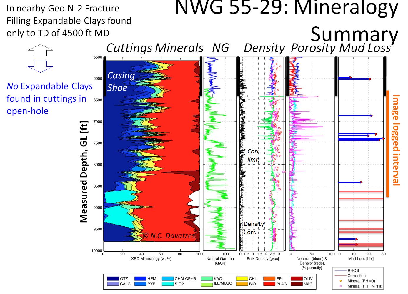
Utah FORGE has been established to develop, test, and improve the technologies and techniques required to develop EGS-type geothermal resources. Drilling of the first of two deep deviated wells,...
-
The Visible Infrared Imaging Radiometer Suite (VIIRS) Active Fires (VJ114IMG) Version 2 product is produced in 6-minute temporal satellite increments (swaths) at 375 meter resolution from the...
-
This dataset contains Ocean Color (OC) Science Quality Environmental Data Records (EDR) Level-2 products from the Visible Infrared Imaging Radiometer Suite (VIIRS) onboard the Suomi-National...
-
This dataset includes results and reports from the injection/production test for wells 16A(78)-32 and 16B(78)-32 in August, 2024 at Utah FORGE. Materials include injection, post stimulation...
-
ERBE_S4G_MFOV_SF_ZG_1 is the Earth Radiation Budget Experiment (ERBE) Non-scanner S-4G Medium-field of View (MFOV) Shape Factor (SF) Zonal and Global Averages data product. Data collection for...
-
ERBE_S4G_WFOV_SF_ZG_1 is the Earth Radiation Budget Experiment (ERBE) S-4G Non-scanner, Wide Field of View (WFOV) Shape Factor (SF) 10 degree Zonal and Global Averages in HDF data product. Data...
-
ERBE_S4G_WFOV_NF_ZG_1 is the Earth Radiation Budget Experiment (ERBE) S-4G Non-scanner, Wide Field of View (WFOV) Numerical Filter (NF) 5 and 10 degree Zonal and Global Averages in HDF data...
-
This dataset contains trace element concentrations from fluid samples collected during the August-September 2024 circulation test at Utah FORGE. Samples were taken from injection well 16A(78)-32,...
-
County-level data from oil and/or natural gas producing States—for onshore production in the lower 48 States only—are compiled on a State-by-State basis. Most States have production statistics...
-
Cell maps for each Paleogene oil and gas assessment unit were created by the USGS to illustrate the degree of exploration, type of production, and distribution of production in an assessment unit...
-
Cell maps for each Miocene and Plio-Pleistocene oil and gas assessment unit were created by the USGS to illustrate the degree of exploration, type of production, and distribution of production in...
-
Cell maps for each oil and gas assessment unit were created by the USGS to illustrate the degree of exploration, type of production, and distribution of production in an assessment unit or...
-
Cell maps for each oil and gas assessment unit were created by the USGS as a method for illustrating the degree of exploration, type of production, and distribution of production in an assessment...
-
Cell maps for each oil and gas assessment unit were created by the USGS as a method for illustrating the degree of exploration, type of production, and distribution of production in an assessment...
-
Cell maps for each oil and gas assessment unit were created by the USGS as a method for illustrating the degree of exploration, type of production, and distribution of production in an assessment...
