
Search Data.gov
Found 9918 dataset(s) matching "universities".
-
Historic Highway Performance Monitoring System universe data for the year 2006
-
The Digital Geomorphic-GIS Map of the Buxton Inlet Area (1:10,000 scale 2006 mapping), North Carolina is composed of GIS data layers and GIS tables, and is available in the following GRI-supported...
-
The Digital Geomorphic-GIS Map of the Great Swash to Quork Hammock Area (1:10,000 scale 2006 mapping), North Carolina is composed of GIS data layers and GIS tables, and is available in the...
-
This dataset records the number and type of degrees awarded by the State University of New York by award type and institution.
-
This archived page provides information about award recipients, project abstracts, and summaries of competitions under the Historically Black Colleges and Universities Program created by the...
-
Historic Highway Performance Monitoring System universe data for the year 1994
-
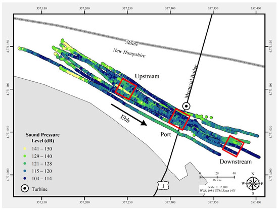
In July 2021, a commercial-off-the-shelf hydrophone was deployed in a free-drifting configuration to measure underwater acoustic emissions and characterize a 25 kW-rated tidal turbine at the...
-
The Digital Geologic-GIS Map of Natural Bridges National Monument, Utah is composed of GIS data layers and GIS tables, and is available in the following GRI-supported GIS data formats: 1.) a 10.1...
-
he Digital Geomorphic-GIS Map of the Little Kinnakeet Area (1:10,000 scale 2006 mapping), North Carolina is composed of GIS data layers and GIS tables, and is available in the following...
-
The Unpublished Digital Geologic-GIS Map of Organ Pipe Cactus National Monument and Vicinity, Arizona is composed of GIS data layers and GIS tables in a 10.1 file geodatabase (orpi_geology.gdb), a...
-
The Digital Geologic-GIS Map of San Antonio Missions National Historical Park and Vicinity, Texas is composed of GIS data layers and GIS tables, and is available in the following GRI-supported GIS...
-
Homeland Infrastructure Foundation-Level Data (HIFLD) geospatial data sets containing information on Colleges and Universities.
-
Measurements made of the Chesapeake Bay Mouth (CBM) by Old Dominion University (ODU) between 2004 and 2006.
-
This dataset includes an Excel file with the results of B-value tests to determine the magnitude of the back pressure required for full saturation of Sierra White granite samples. Test were...
-
Background To examine research background, attitudes, knowledge and skills of family medicine residents with regard to primary care research and to compare residents who elected to...
-
These data provide land cover classifications derived from the Boston University MOD12Q1 V004 MODIS/Terra 1 km Land Cover Product (Friedl et al. 2002). The data are available in various EASE-Grid...
-
These Land-Ocean-Coastline-Ice (LOCI) files provide land classification masks derived from the Boston University MOD12Q1 V004 MODIS/Terra 1 km Land Cover Product (Friedl et al. 2002). The masks...
-
The compressed (.zip) file contains Datawell MK-III Directional Waverider binary and unpacked data files as well as a description of the data and manuals for the instrumentation. The data files...
-
<p>PAUP Study for Resilient Economic Agricultural Practices in University Park, Pennsylvania</p> <div><br>Resources in this dataset:</div><br><ul><li><p>Resource Title: GeoData catalog record.</p>...
-
These Land-Ocean-Coastline-Ice (LOCI) files provide land classification masks derived from the Boston University MOD12Q1 V004 MODIS/Terra 1 km Land Cover Product (Friedl et al. 2002). The masks...
