
Search Data.gov
Found 437 dataset(s) matching "geothermal survey".
-
This release presents provisional volcanic gas monitoring data from multi-GAS (multiple Gas Analyzer System) station "YELL_MUD", installed in July 2021 in the Obsidian Pool thermal area,...
-
This data submission includes several data components that were used to develop a conceptual model and power capacity-estimates of two low-temperature geothermal resources that define geothermal...
-
Measurement of sulfur dioxide (SO2) emission rates is a critical aspect of monitoring and studying active volcanoes. Changes in emission rate are often associated with changes in volcanic activity...
-
This data release consists of three products relating to a 82 x 50 neuron Emergent Self-Organizing Map (ESOM), which describes the multivariate topology of reservoir temperature and geochemical...
-
This data matrix contains the codebook vectors for a 82 x 50 neuron Emergent Self-Organizing Map which describes the multivariate topology of reservoir temperature and geochemical data for 190...
-
This archive contains temperature data for Roosevelt Hot Springs observation wells OH-1, OH-4, OH-5 and OH-7. There are also mud logs for OH-4. These are old datasets obtained from Rocky Mountain...
-
These resources describe the 3D geophysical inversion modeling of gravity data at the FORGE site near Milford, Utah. FORGE is the Frontier Observatory for Research in Geothermal Energy and the...
-
Geothermal Technologies Program Peer Review Presentation on Blind Geothermal System Exploration in Active Volcanic Environments. Includes plans and statuses for multi-phase geophysical and...
-
Geothermal Technologies Program Peer Review Presentation on Blind Geothermal System Exploration in Active Volcanic Environments. Includes plans and statuses for multi-phase geophysical and...
-
This is a presentation on the Joint Electromagnetic/Seismic/InSAR Imaging of Spatial-Temporal Fracture Growth and Estimation of Physical Fracture Properties During EGS Resource Development project...
-
There are 487 onshore oil and gas fields in California encompassing 3,392 square miles of aggregated area. The California State Water Resources Control Board (State Water Board) initiated a...
-
During hydrocarbon production, water is typically co-produced from the geologic formations producing oil and gas. Understanding the composition of these produced waters is important to help...
-
During hydrocarbon production, water is typically co-produced from the geologic formations producing oil and gas. Understanding the composition of these produced waters is important to help...
-
There are 487 onshore oil and gas fields in California encompassing 3,392 square miles of aggregated area. The California State Water Resources Control Board (State Water Board) initiated a...
-
There are 487 onshore oil and gas fields in California encompassing 3,392 square miles of aggregated area. The California State Water Resources Control Board (State Water Board) initiated a...
-
There are 487 onshore oil and gas fields in California encompassing 3,392 square miles of aggregated area. The California State Water Resources Control Board (State Water Board) initiated a...
-
Preliminary locations for intermediate depth temperature gradient holes and/or resource confirmation wells based on compilation of geological, geophysical and geochemical data prior to carrying...
-
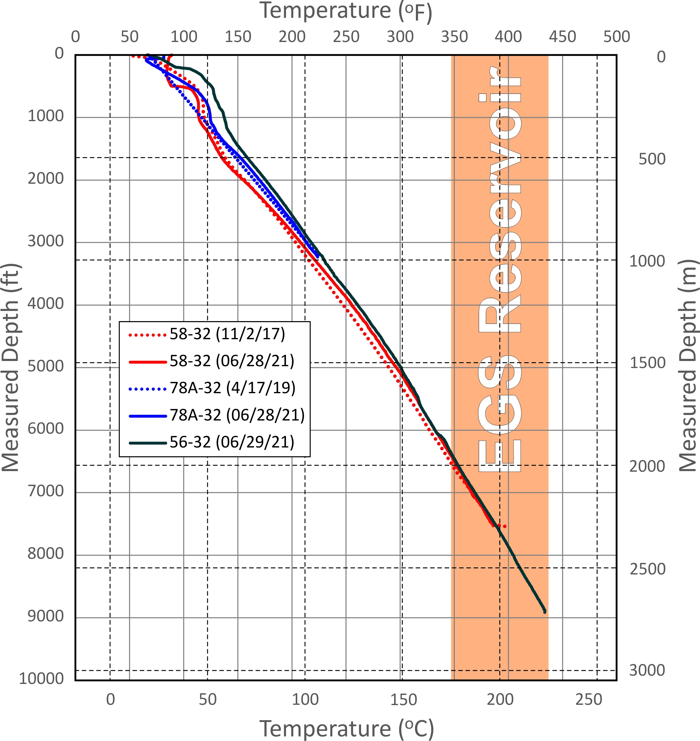
This dataset includes updated temperature and pressure logs for Utah FORGE wells 56-32, 78-32, and 58-32. This data was acquired in June 2021.
-
This geodatabase was built to cover several geothermal targets developed by Flint Geothermal in 2012 during a search for high-temperature systems that could be exploited for electric power...
-
Previous moderate- and high-temperature geothermal resource assessments of the western United States utilized data-driven methods and expert decisions to estimate resource favorability. Although...
