
Search Data.gov
Found 651 dataset(s) matching "fractures".
-
MODFLOW-NWT groundwater flow models and MODPATH6 particle tracking simulations were developed to determine contributing areas (CAs) for and advective travel times to domestic wells under extreme...
-
The Cahuilla Valley and Terwilliger Valley groundwater basins, 9-006 and 7-026 respectively (California Department of Water Resources 2016) located approximately 25 miles southwest of Palm...
-
Multiple subaerial landslides adjacent to Prince William Sound, Alaska (for example, Dai and others, 2020; Higman and others, 2023; Schaefer and others, 2024) pose a threat to the public because...
-
A shapefile of 311 undersea features from all major oceans and seas has been created as an aid for retrieving georeferenced information resources. Version 1.1 of the data set also includes a...
-
Plugging of fracture porosity from mineral precipitation due to injecting cold water into a a geothermal reservoir can impact the overall permeability of the fracture network in the reservoir....
-
This file contains a list of relevant references on the Biot theory (forward and inverse approaches), the double-porosity and dual-permeability theory, and seismic wave propagation in fracture...
-
EGS field projects have not sustained production at rates greater than 1/2 of what is needed for economic viability. The primary limitation that makes commercial EGS infeasible is our current...
-
A water-supply plan is being developed for Wake County, North Carolina, in accordance with the 50-year planning window used by the North Carolina Division of Water Resources for residents in...
-
The Marcellus Shale Energy and Environment Laboratory (MSEEL) is part of the Northeast Natural Energy LLC (NNE) production facility on the Monongahela River in Monongalia County, West Virginia,...
-
This U.S. Geological Survey (USGS) Data Release is focused on the geochemistry of wastewater (including flowback and produced water) samples, co-produced with natural gas, collected from the...
-
This layer traces apparent topographic and air-photo lineaments in the area around Pagosa springs in Archuleta County, Colorado. It was made in order to identify possible fault and fracture...
-
The files in this submission describes the results of a series of stress measurement and hydraulic fracturing experiments conducted at the Sanford Underground Research Facility (SURF) in Lead, SD....
-
FracFocus is the national hydraulic fracturing chemical registry. Each FracFocus record is composed of three parts: 1. Well information including API number, job start and end date, state and...
-
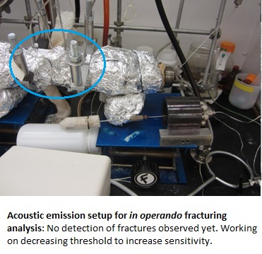
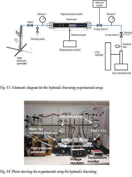
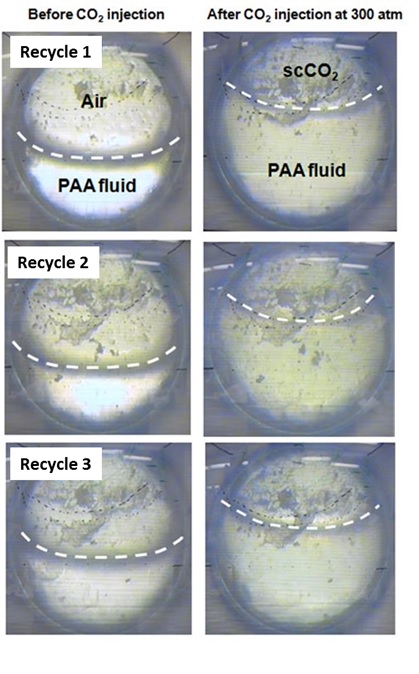
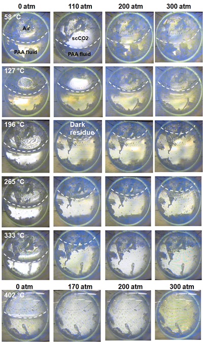
A corrigendum was submitted to the journal of Geothermics on our article "Environmentally friendly, rheoreversible, hydraulic-fracturing fluids for enhanced geothermal systems" Shao et al...
-
EGS field projects have not sustained production at rates greater than half of what is needed for economic viability. The primary limitation that makes commercial EGS infeasible is our current...
-
In order to determine the innate microbial community of shale gas reservoirs and how they are impacted by hydraulic fracturing, this study analyzed biomass collected from produced water and rock...
-
Included are datasets from wellbore breakout experiments conducted under triaxial conditions with varying fluid and temperature environments. This dataset serves as one of the experimental reports...
-
The 1:100,000-scale geologic map of the South Boston 30' x 60' quadrangle, Virginia and North Carolina, provides geologic information for the Piedmont along the I-85 and U.S. Route 58 corridors...
