
Search Data.gov
Found 1168 dataset(s) matching "well test".
-
This dataset presents tabular data and Excel workbooks used to analyze single-well aquifer tests in pumping wells and slug tests in monitoring wells near Long Canyon. The data also include pdf...
-
This USGS data release represents tabular data and water-level modeling files for the 16 Pahute Mesa multiple-well aquifer tests conducted from 2009–2014. These datasets represent raw and...
-
The National Training Center (NTC) at US Army Fort Irwin, CA (Fort Irwin) has a stormwater collection system located near the Sleepy Hollow housing area that includes a stormwater catchment basin,...
-
This data release consists of two directories: DepthToWater and WaterLevelModels. The DepthToWater directory contains five Microsoft Excel workbooks that present depth-to-groundwater data and...
-
This data release contains hydraulic conductivity data from single well (slug) tests conducted from the slag-filled material of the open interval of monitoring well 37N14E-13.3a1 (MW2, United...
-
Scanned Well Potential Test Reports Online Query - You can now request these same well files, well logs, and well data as a free download through the File Request System (...
-
During the spring and summer of 2020, the U.S. Geological Survey, Lower Mississippi – Gulf Water Science Center, conducted single well slug tests on selected wells within the Mississippi Alluvial...
-
This USGS data release represents tabular data and water-level modeling files for the 16 Pahute Mesa multiple-well aquifer tests conducted from 2009–2014. This dataset represents water-level...
-
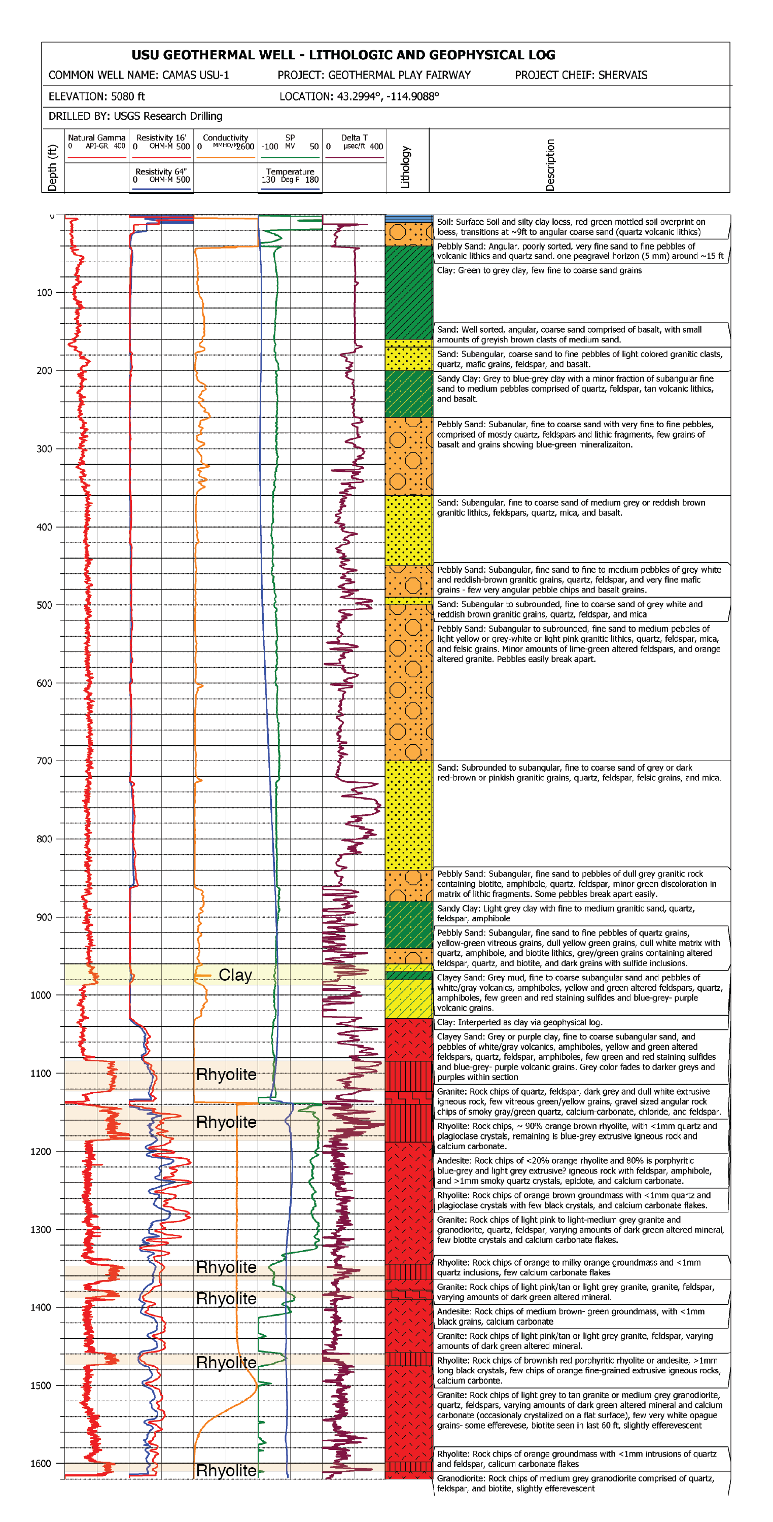
This report documents the post-hydraulic fracturing extended circulation test between Utah FORGE wells 16A and 16B conducted in August 2024. In well 16B, fiber optic measurements of Rayleigh...
-
This USGS data release represents tabular data and water-level modeling files for the 16 Pahute Mesa multiple-well aquifer tests conducted from 2009–2014. This dataset represents water-level...
-
Water level, water temperature, and specific conductance data were collected during natural gradient tests on six observation wells screened in the upper transmissive zone of the Ogallala aquifer...
-
This archive consists of a pdf graphic log and a LAS text file representing the results of the pressure and temperature logs measured on Nov. 8th, 2018 from the Utah FORGE deep test well 58-32...
-
Hydrologic influences on water levels were investigated at Three Oaks Recreation Area (TORA), a former sand-and-gravel quarry converted into recreational lakes in Crystal Lake, Illinois. From 2009...
-
This data release contains observed water-level recovery data in 52 wells, matched to theoretical type curves defined by postulated values of aquifer transmissivity and storage, that together...
-
This data release presents tabular data used and analytical water-level modeling files generated as part of a U.S. Geological Survey study, done in cooperation with the Confederated Tribes of the...
-
The EGS Collab project is evaluating a site for Experiment 2 (hydraulic fracturing/shearing) at a depth of 1.25 km in the Sanford Underground Research Facility (SURF) on the 4100 Level. Two early...
-
U.S. Geological Survey (USGS) in cooperation with the U.S. Air Force Civil Engineering Center conducted short-term aquifer tests at 11 wells to estimate hydraulic properties in the Fountain Creek...
-
Groundwater level dataset from test well E-14 in Las Cienegas National Conservation Area (2011–2021)
This dataset contains groundwater levels collected from a test well installed in the basin-fill aquifer within the Las Cienegas National Conservation Area. The groundwater levels are from discrete...
