
Search Data.gov
Found 43 dataset(s) matching "Utah Play Fairway".
-
This is a zipped archive containing an ArcGIS shapefile and a text file containing gravity data covering the Cove Fort and Dog Valley areas in central Utah. Part of the data was acquired by the...
-
This submission contains a link to two USGS data publications. Each data release contains all digital geographic data used and produced by the Snake River Plain Play Fairway Analysis for Phase 1...
-
This presents the results of Phase 1 of the Snake River Plain Play Fairway Analysis project, along with a proposed work for Phase 2. No new data were collected, but we list data sources for our...
-
This submission includes a geotiff of the geographic extent of Pleistocene Lake Otero; which was used as apart of the groundwater composite risk segment in a Tularosa Basin Play Fairway Analysis.
-
This is the final report for the second phase of geological, geophysical, and geochemical data collection and processing for the Eastern Great Basin Geothermal Play Fairway Analysis project.
-
This is a zipped ArcGIS shapefile containing faults mapped for the Tularosa Basin geothermal play fairway analysis project. The faults were interpolated from gravity and seismic (NASA area) data,...
-
Snake River Plain Geothermal Play Fairway Analysis Heat, Permeability, and Seal CRS Map Raster Files
Snake River Plain Play Fairway Analysis - Phase 1 CRS Raster Files. This dataset contains raster files created in ArcGIS. These raster images depict Common Risk Segment (CRS) maps for HEAT,...
-
This submission includes the final project report of the Snake River Plain Play Fairway Analysis project as well as a separate appendix for the final report. The final report outlines the...
-
This submission includes a Na/K geothermometer probability greater than 200 deg C map, as well as two play fairway analysis (PFA) models. The probability map acts as a composite risk segment for...
-
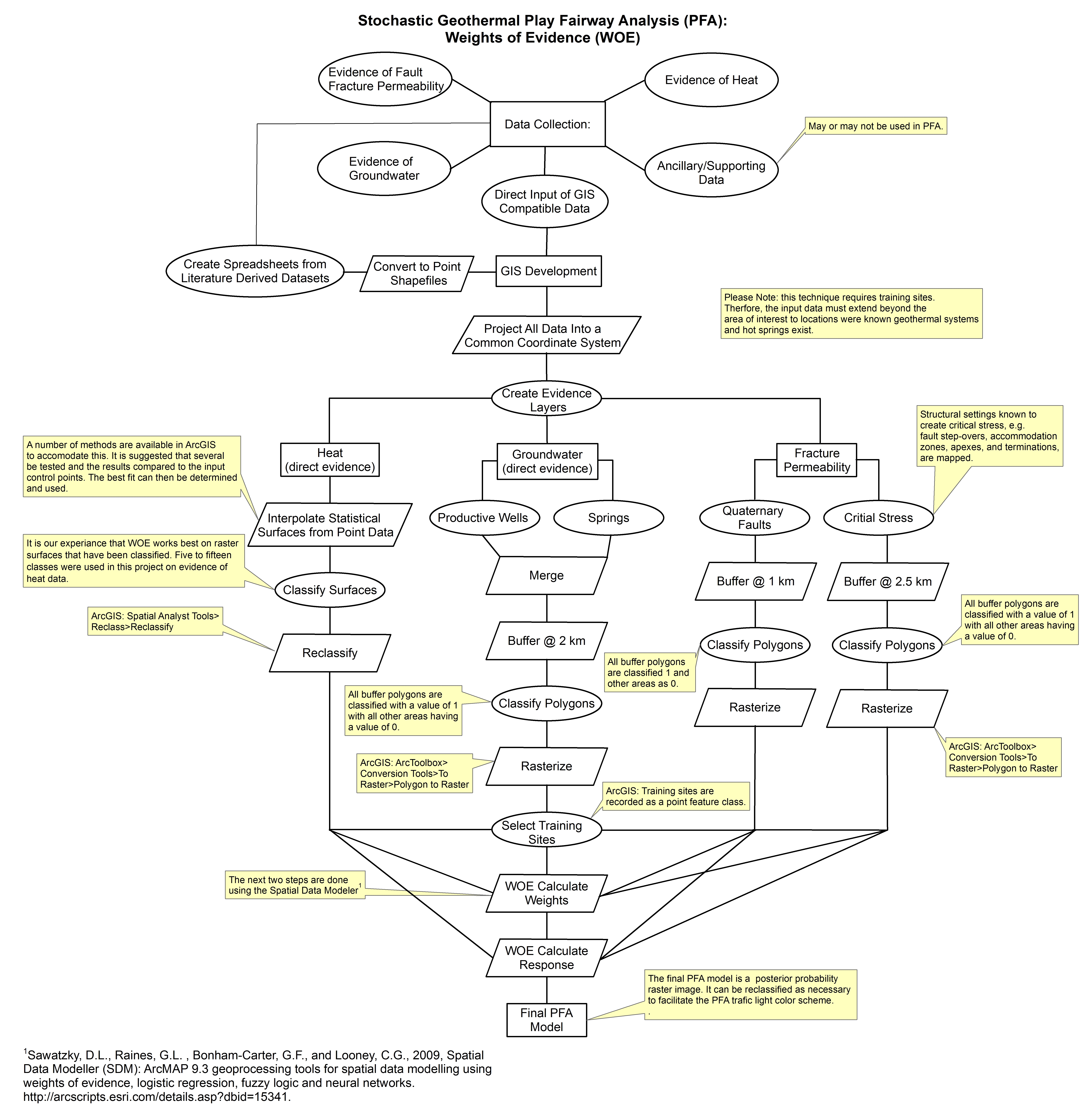
These models are related to weights of evidence play fairway anlaysis of the Tularosa Basin, New Mexico and Texas. They were created through Spatial Data Modeler: ArcMAP 9.3 geoprocessing tools...
-
The Mountain Home area is characterized by high heat flow and temperature gradient. Temperature data are available from 18 boreholes with depths equal to or greater than 200 m, 5 of which have...
-
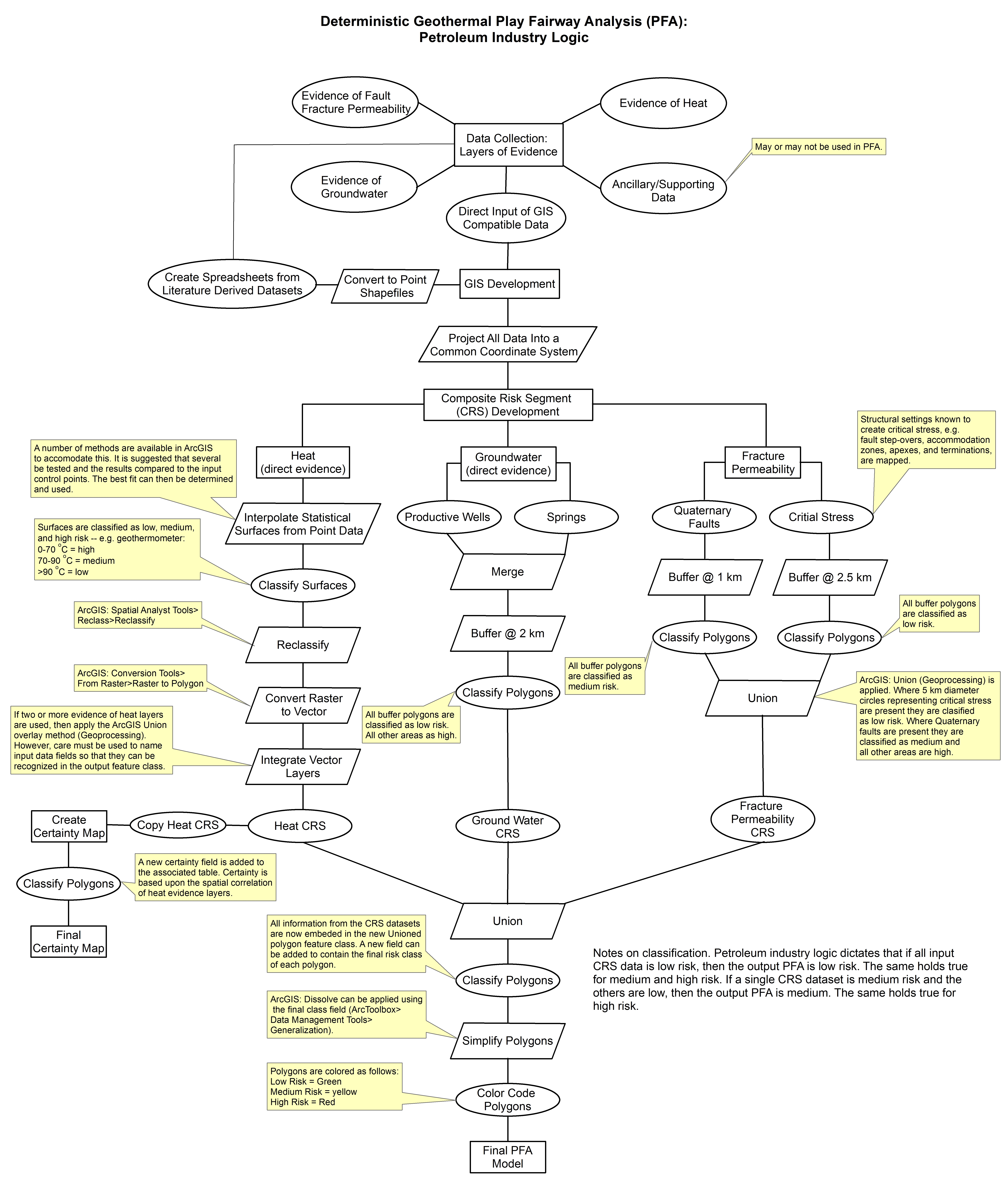
These images show the comprehensive methodology used for creation of a Play Fairway Analysis to explore the geothermal resource potential of the Tularosa Basin, New Mexico. The deterministic...
-
This report presents the results of Phase 2 of the Snake River Plain Play Fairway Analysis project, and a summary of proposed work for Phase 3. Phase 2 focused on new data collection in specific...
-
This is a zipped file containing raw magnetotelluric (MT) data collected as part of the Phase 2 Tularosa Basin geothermal play fairway analysis project in New Mexico. The data for each MT station...
