
Search Data.gov
Found 148 dataset(s) matching "EGS survey".
-
This package includes data and footage from two rounds of downhole camera surveys performed at the Sanford Underground Research Facility (SURF) on the 4850 level. The exercise was performed once...
-
The Utah FORGE project collaborated with the University of Utahs Department of Communication on a Capstone course during Fall Semester 2020. The course created a survey to gauge the general...
-
This is a link to the Utah Geological Survey's Utah FORGE Interactive Geoscience Map. The map layers include information on geology, geography, subsurface temperatures, seismicity, gravity and...
-
This is a presentation on the Evolution of Permeability and Strength Recovery of Shear Fractures Under Hydrothermal Conditions project by the U.S. Geological Survey, presented by Dr. David...
-
This table contains the X-ray sources detected in the AEGIS-X survey, a series of deep Chandra ACIS-I observations of the Extended Groth Strip (EGS). The survey comprises pointings at eight...
-
Coastal ecosystem goods and services (EGS) have steadily gained traction in the scientific literature over the last few decades, providing a wealth of information about underlying coastal habitat...
-
Single-beam bathymetry data along with SINS navigation data was collected as part of the U.S. Geological Survey cruise D-1-79-EG. The cruise was conducted in the Eastern Gulf of Alaska from May 24...
-
Single-beam bathymetry data along with dead reckoning navigation data was collected as part of the U.S. Geological Survey cruise G-1-77-EG. The cruise was conducted in Yakutat Bay, Eastern Gulf of...
-
Single-beam bathymetry data along with radar and Loran-C navigation data was collected as part of the U.S. Geological Survey cruise G-1-77-EG. The cruise was conducted in Southern California from...
-
This table contains results from AEGIS20, a radio survey of the Extended Groth Strip (EGS) conducted with the Very Large Array (VLA) at a frequency of 1.4 GHz. The resulting catalog contains 1122...
-
From February 12 to March 8, 1981, EG and G Geometrics conducted an aeromagnetic survey in Montana for Anaconda Copper Company. A Piper Navajo aircraft was used to conducted the survey. The survey...
-
Utah FORGE has been established to develop, test, and improve the technologies and techniques required to develop EGS-type geothermal resources. Drilling of the first of two deep deviated wells,...
-
A 4D microgravity survey began in early 2019 in order to benchmark surface and subsurface elevations prior to Phase 3 drilling and stimulation campaigns. Microgravity stations are collocated with...
-
Groundwater data around the Utah FORGE site has been collected to determine the piezometric levels and compositional variability. Field measurements in 2020 are designed to obtain and survey new...
-
Laboratory slide-hold-slide tests were conducted in a conventional triaxial deformation configuration on 1-inch diameter cylindrical cores of Westerly granite bisected by a sawcut oriented at 30...
-
Previous moderate- and high-temperature geothermal resource assessments of the western United States utilized data-driven methods and expert decisions to estimate resource favorability. Although...
-
This report discusses the results of research on the ability to create and/or reactivate and subsequently sustain fracture systems which are strongly influenced by complexly coupled mechanical (M)...
-
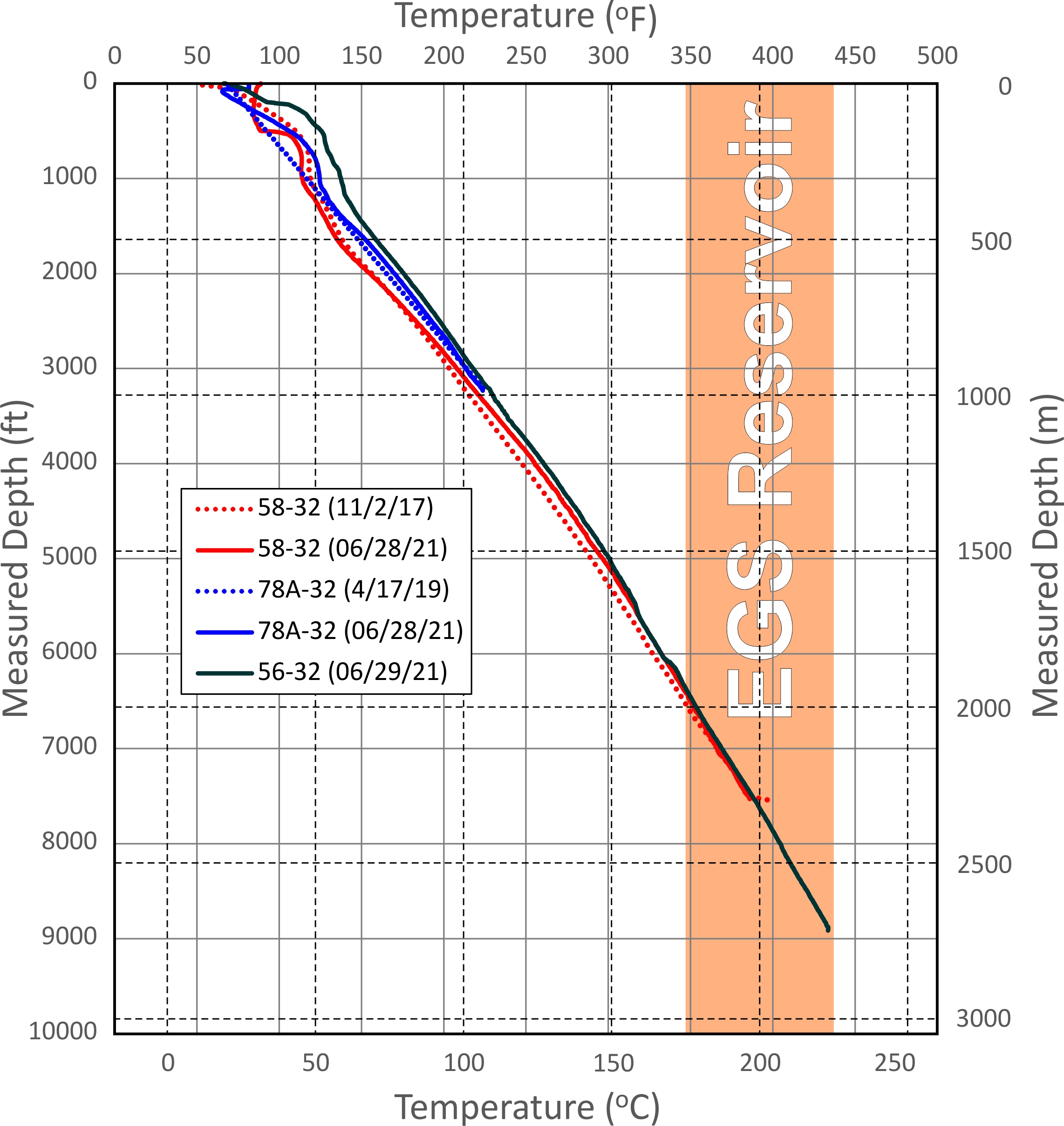
This dataset includes updated temperature and pressure logs for Utah FORGE wells 56-32, 78-32, and 58-32. This data was acquired in June 2021.
-
Geologic structure and isopach maps were constructed by interpreting over 19,890 trackline kilometers of co-located multichannel boomer, sparker and chirp seismic reflection profiles from the...
